I first went to Greece in 1979. I was a callow Scottish youth fresh out of university. Travelling from London with a mate on an increasingly smelly “Magic Bus” across Europe, it took us three days and three nights to reach Athens. We then spent a couple of months sleeping on Greek beaches, chatting up women (mostly unsuccessfully) and living largely on a diet of beer, bread and cigarettes. I lost two stones in weight during my time there.
That summer of island hopping on slow and invariably delayed Greek ferries was one of the most enjoyable periods of my life. It was a temporary escape from having to knuckle down and accept I was not going to be an international rock star and, therefore, needed to adapt to the idea of working regular hours for some kind of regular pay.
In simple terms, in 1979 I fell in love with Greece and its people. I subsequently returned for a couple of weeks of escape from work most summers, unwittingly slipping into an overly comfortable routine of visiting the same favourite places year after year. In particular, I’ve been to the islands of Samos and Ikaria more times than I can remember.
In 2013, in my mid-fifties, self-employed, divorced and re-married, my wife and I agreed that, as we lived, worked and did most other things together, there was no harm in us spending some time apart and doing different things on our holidays. This meant my wife could indulge her inexplicable passion for Turkey, where she had enjoyed her defining youthful adventure, while I could put a rucksack on my back and start exploring some new parts of Greece. Travelling with rucksacks and no fixed itinerary was, and still is, my wife’s idea of a holiday from hell.
Between 2013 and 2019, what was an initial two-week break each year extended into two annual visits lasting a total of five or six weeks, until Covid got in the way. In that time I concentrated on exploring islands, visiting as many new ones as possible as well as around 20 old favourites, ticking them off a studiously researched list as middle-aged male anoraks tend to do. Now that Covid appears to be over to a large extent, I am back in the routine of regular visits back to my happy place.
No one seems to know for sure how many Greek islands there actually are, or how many of them are populated. I’ve seen estimates ranging from 1,200 to 6,000 for the former and 150 to 230 for the latter. All of these figures sound like exaggerations, unless you count every rock that just about juts out of the sea as an island. To date, I have visited just over 90 islands and most (but not all) parts of the mainland.
I have a particular obsession with reaching remote, out of the way islands like Agios Efstratios, Psara and Antikythira. This is partly due to the challenge (and satisfaction) of getting there and partly because they tend to have a more relaxed, more traditional Greek atmosphere that reminds me, to some extent, of what I found on my first visit in 1979.
This site is primarily a few recollections of the places I have visited. It is not a detailed summary of their histories, facilities or attractions. In some places I was just a day visitor. However, I stayed at least a few nights in the vast majority and, being a keen walker, I made a point of trying to explore as much as I could.
I still have further places to explore and many more that I want to revisit. I have now finally reached the age of retirement and joined the LBC (Lucky Bastards Club). As far as I’m concerned, exploring Greece is as good a way as any to spend my retirement and a damn sight better than wasting my time lingering around chilly UK DIY superstores.
My thoughts and comments on individual islands are outlined alphabetically by island group as follows.
Crete
2 islands: Crete & Gavdos.
Greece’s largest, most independently minded island and its small, remote neighbour.Offer a huge variety of history, scenery and beaches.
The most westerly island group with a notable Italianate influence. Greener and lusher than other island groups.Particularly popular with British visitors.
A group of small islands close to Athens. Attract a lot of day visitors from Greece’s capital city, giving them more of a cosmopolitan atmosphere than other groups.
A catch all collection of islands that don’t fit naturally into other groups. Scattered about Greece, mostly very close to the mainland.
I have taken most of the photographs used on this site. However, I am a pretty lousy photographer who occasionally had to deal with dull and grey weather conditions. Therefore I have downloaded some better images from what I understand to be copyright free websites. Apologies to anyone who might be unhappy with my use of their images. I will remove any images on request.
Large and diverse enough to almost be a country in its own right. One for history buffs as well as beach lovers.
First visited in 1979. Most recently visited in 2019.
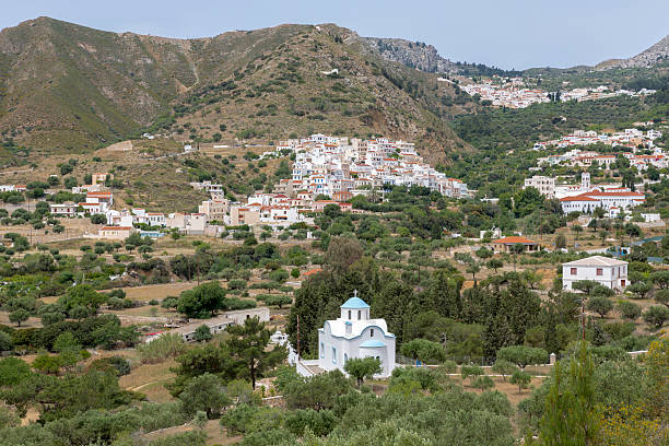
As Crete is the largest island in Greece and the first island in the country that I visited way back in 1979, it seems appropriate to start my musings there.
With a long history, spectacular scenery and beautiful beaches, Crete has always been ripe for modern tourism development. It has no less than three airports, two of which attract regular international and domestic flights. It is also served by numerous fast hydrofoil and ferry services to Piraeus and many Greek islands. However, it’s location on the southern tip of Greece, means that ferries to and from Piraeus generally take at least 10 hours each way and a lot longer if they stop other islands along the route.
There are five main towns on Crete. All of them are located on the more populated and developed north coast. Moving from west to east, they are Chania, Rethymnon, Heraklion (the island capital), Ayios Nikolaos and Sitia. Ierapetra is the only town of any significant size on the south coast. All of the towns have some historical and scenic interest and most are adjacent to smaller, more recently developed holiday resort areas built beside local beaches.
Parts of Crete have been tastelessly overdeveloped for mass tourism markets, especially along its north east coast. However there are still many quieter corners, as well as more upmarket resorts that retain some of Greek authentic charm. In a nutshell, Crete has something for everyone, be it booze fuelled sunbed factories that party from dusk to dawn, or sleepy rural villages that have changed little in the past two or three centuries.
Given its size and diversity, I have divided Crete into a number of discrete areas rather than try to cover the whole island in one entry. I have been to most parts of the island. However, I cannot claim to know every inch of it intimately. In particular, I have never got round to fully exploring the central part of its south coast. Nonetheless, I hope this may be a helpful initial guide to what is a beautiful and interesting island.
As it doesn’t fit into any specific island group, I have also included eccentric little Gavdos, Crete’s remote, southerly satellite island, in this section.
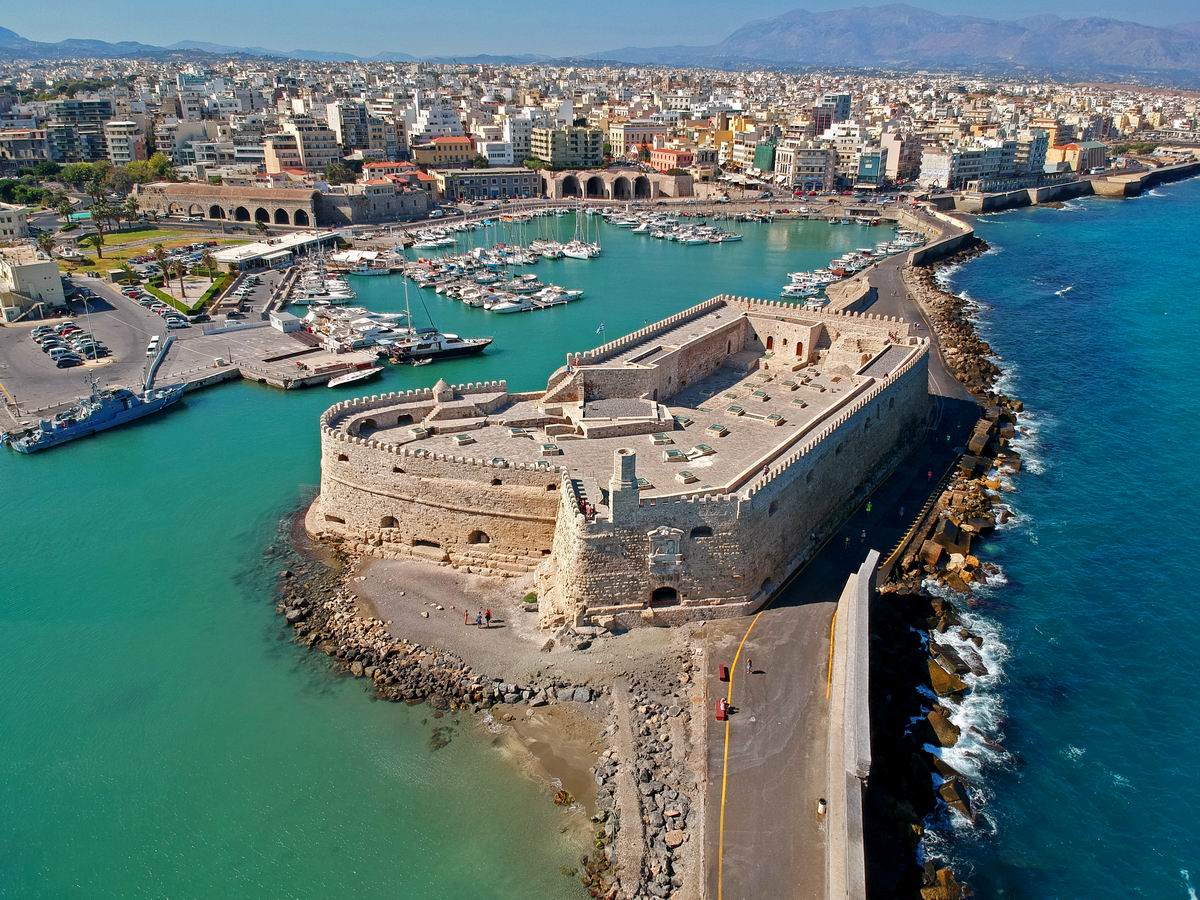
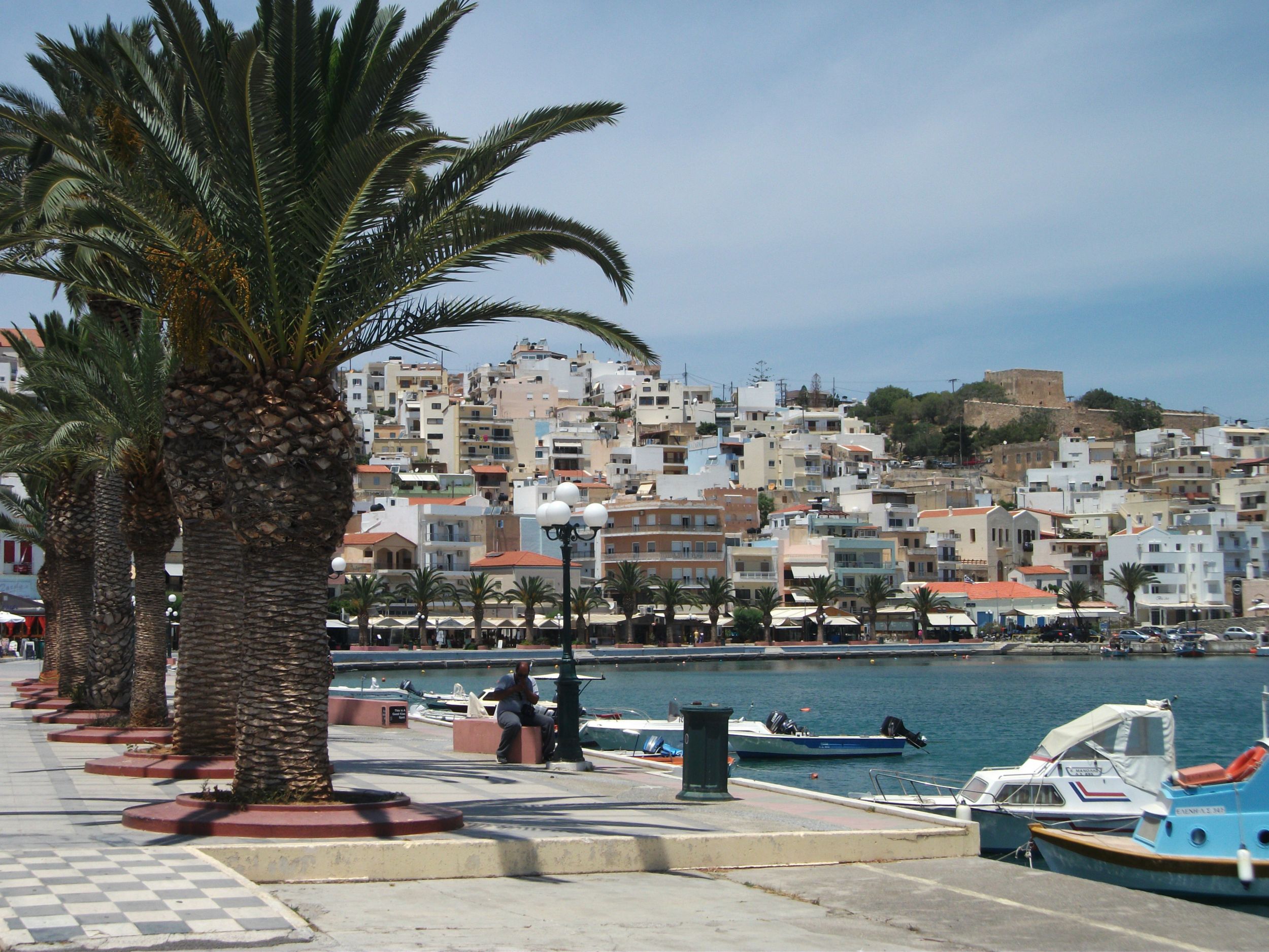
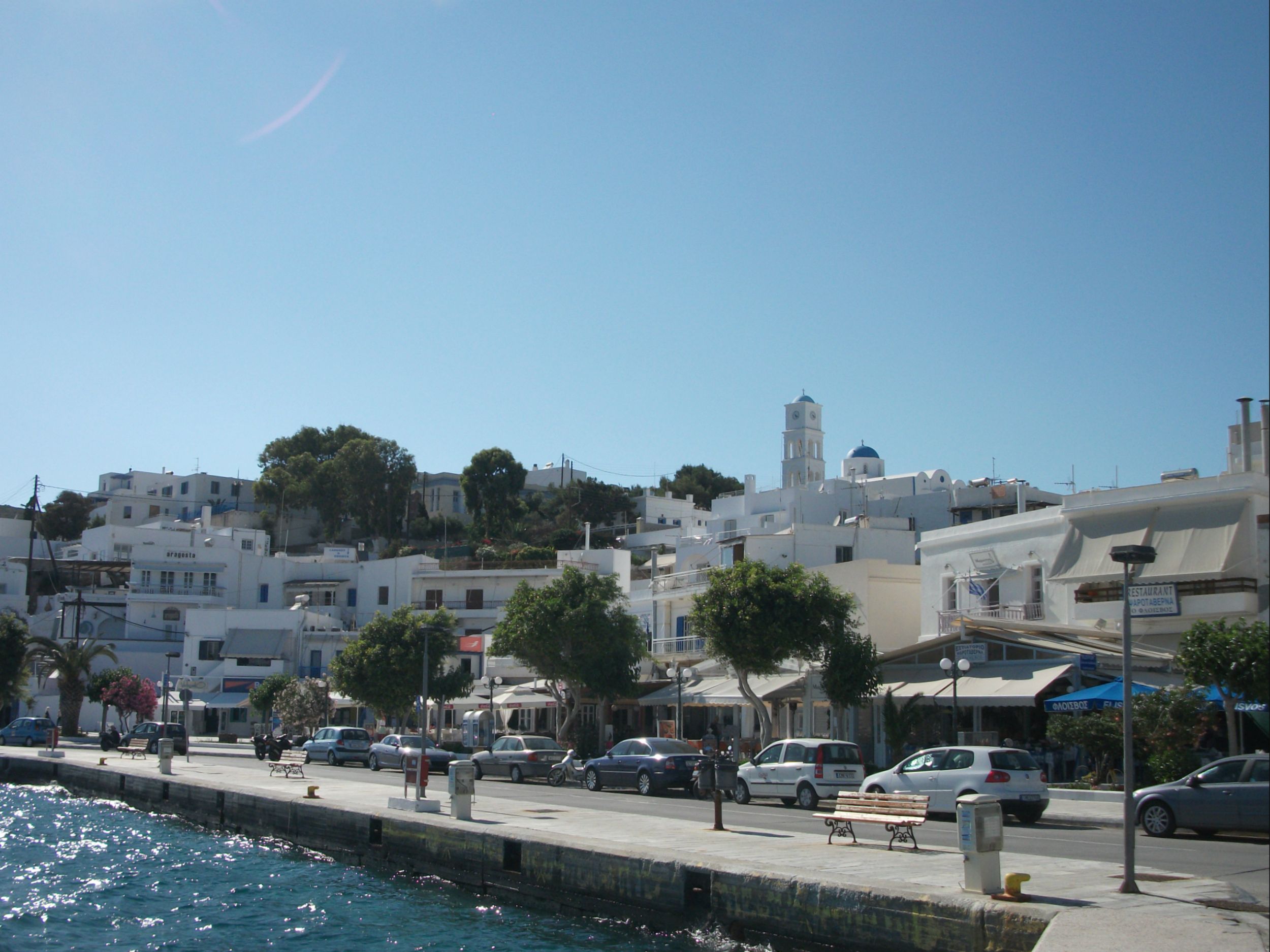
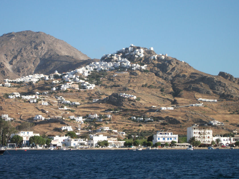
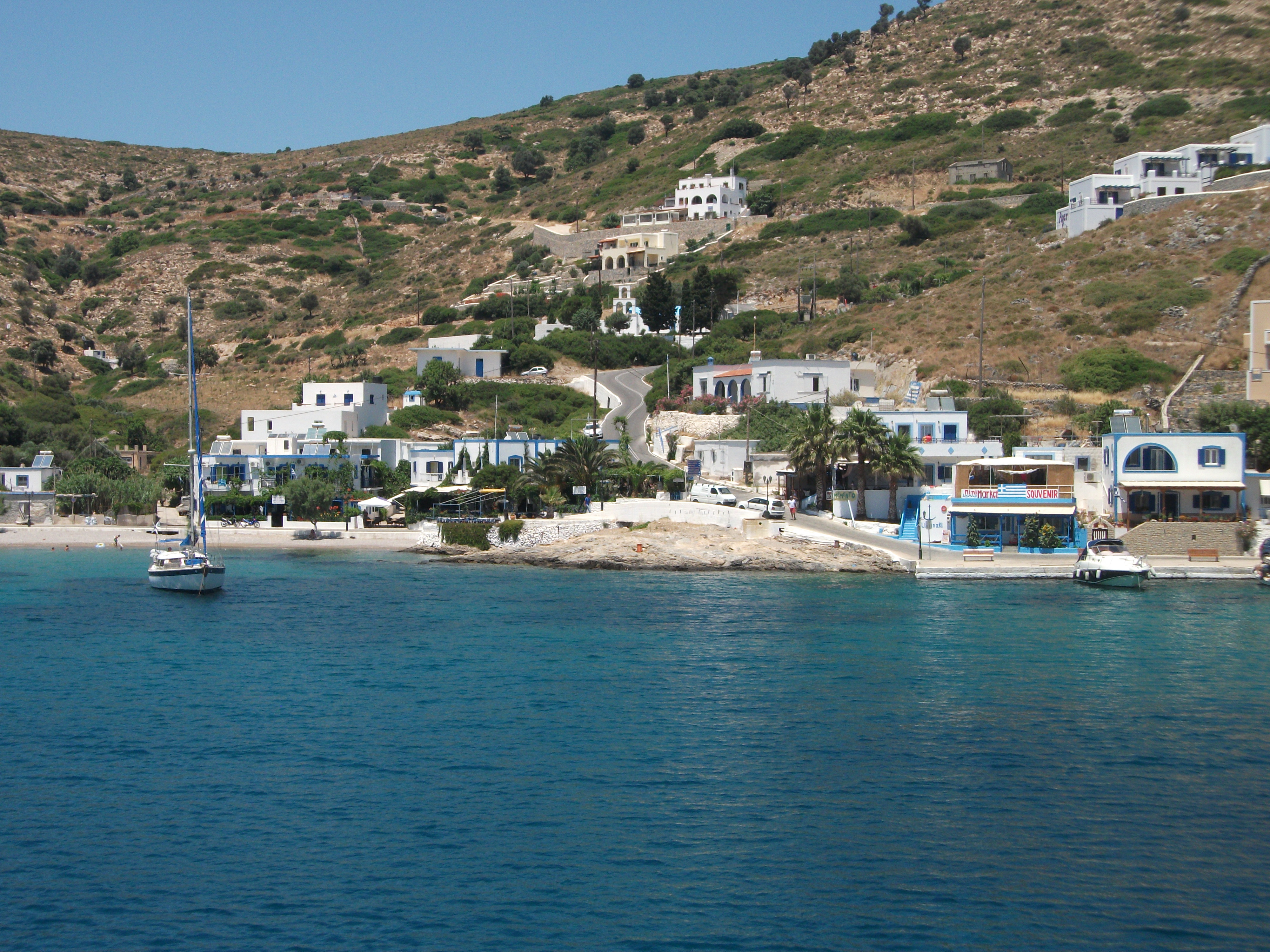
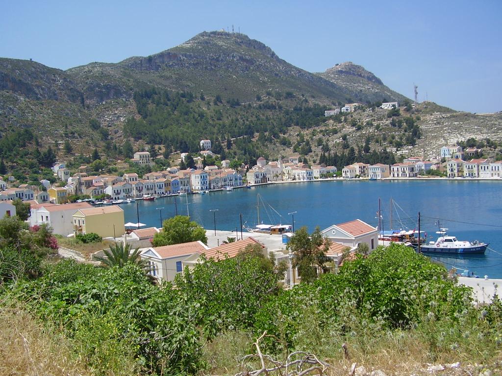
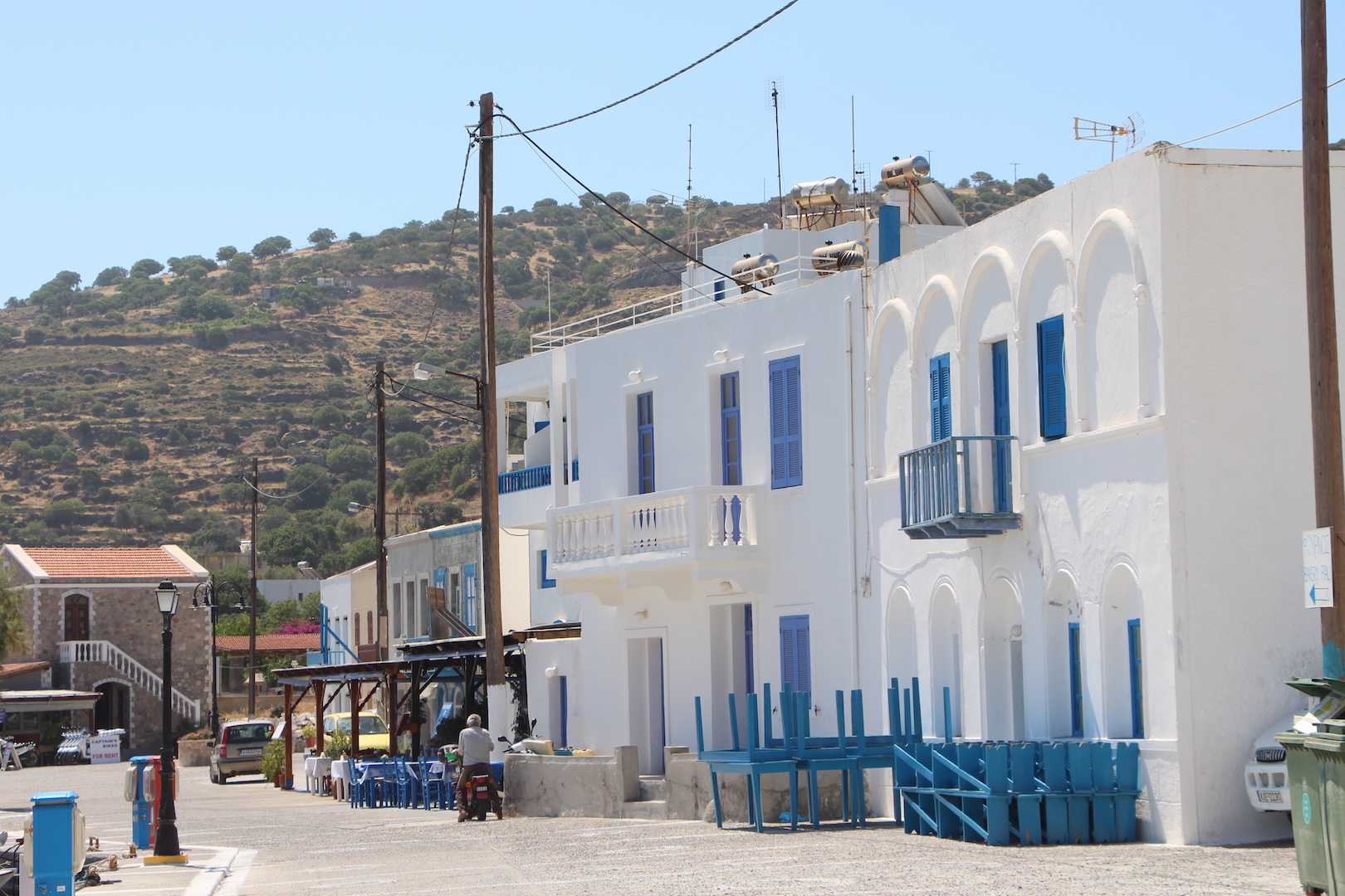
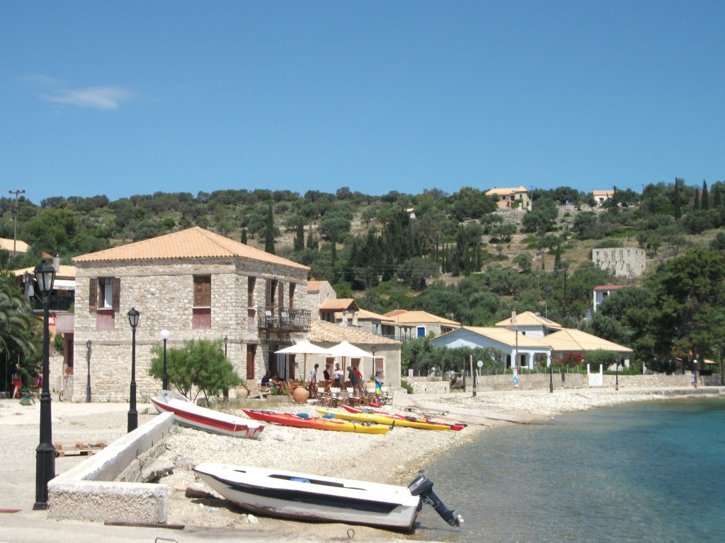
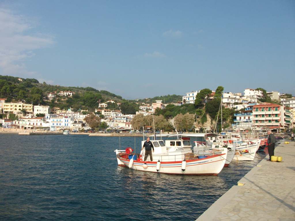
Heraklion
Heraklion – Venetian Fort & Old Harbour
Crete’s capital is a largely modern city of around 150,000 people. It is centrally located on the north coast and is the main air and sea point of access into the island. It is also the main start point for the extensive network of bus services that spread out across the island in all directions.
The airport is only 4 km east of the city and has regular buses into the centre although they stop at around 11 o’clock in the evening. However, taxis are plentiful and relatively cheap.
The modern port area where ferries arrive and depart stretches east from a medieval harbour that is overlooked by a Venetian fort and is now mainly used by small fishing boats and pleasure craft. There is a cluster of mid-range hotels overlooking the modern port. Most visitors head there if arriving late at night or for a single night stay before moving on elsewhere. The two main bus stations are adjacent to most of these hotels. One is for local services in and around the city and the other is the departure point for services to other parts of the island. It’s a short five minute walk between the two.
Heraklion
There are a few restaurants and bars down at the port area, which, like all such localities around the world, has a slightly rough and seedy atmosphere at night, although I personally have never felt uneasy or threatened there. A particularly good traditional waterfront taverna is hidden away behind some warehouses and is where I usually head for the first grilled octopus and Mythos beer of my holiday. It stays open until the last customer leaves. Or so I assume. I’ve never been the last customer in the place despite often arriving after 11pm and leaving well after midnight.
25-Avgoustou, the main street in Heraklion, is a short 10 minute walk west of the new port and climbs uphill from the old harbour. It is lined with lively restaurants and cafes as well as shops, banks, travel agencies and some attractive historic buildings. It ends at Venizelou Square from where more shopping streets run east to Eleftherias, the main city square. This houses the most upmarket shops and restaurants and is adjacent to both the main tourist office and the archaeological museum. There are other museums scattered around the city centre.
Heraklion Archaeological Museum
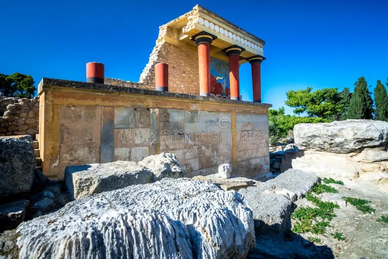
Knossos, the most significant ancient site on Crete, lies just to the south of Heraklion and is served by regular local buses. A large Minoan palace dating back more than 3,000 years, it was extensively excavated and somewhat controversially partly reconstructed in the early 20th century. To be honest, I’ve never been there myself despite many visits to Crete. I’m not sure why, maybe oversight on my part. However, it is heavily promoted as a must-see element of any visit to the island.
Knossos
Heraklion is maybe not a place to spend a relaxing week or fortnight on a sunbed, although there are some good beaches within a short bus ride. However, the nearby beachside villages are largely nondescript, modern constructs with little character or charm.
For me, Heraklion has always very much been a place to pass through as quickly as possible. That said, it also has more than enough to see and do to justify a short break of two or three nights.
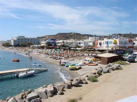
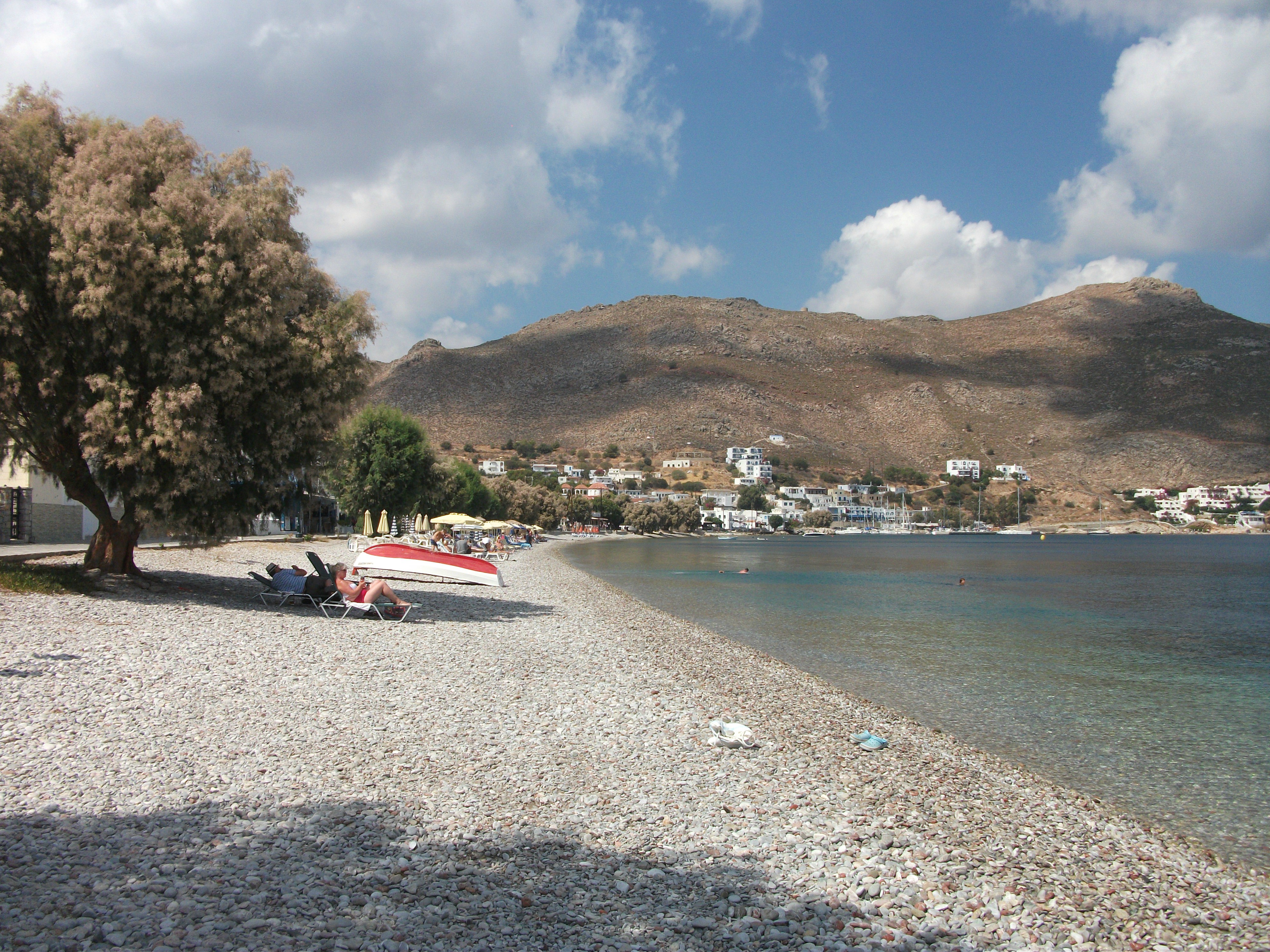
The North East Coast
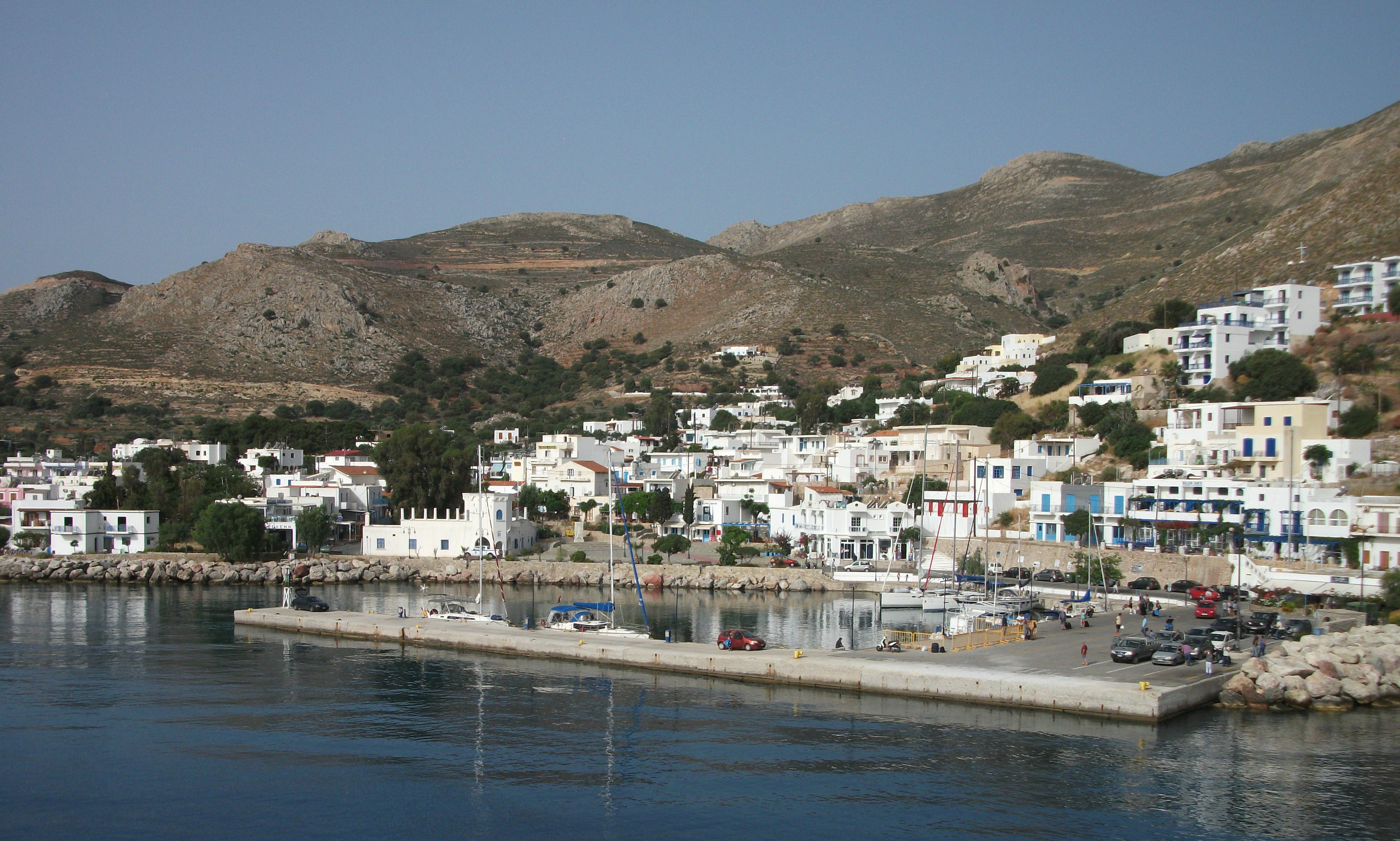
Elounda
The north coast immediately to the east of Heraklion is disparagingly known in some quarters as “the package holiday coast”. Its proximity to Crete’s main airport made it one of the first areas on the island to be developed for mass tourism.
On my first visit to Crete, I initially stayed on this coast at a campsite at Hersonissos, then a quiet fishing village with some early signs of tourism development. At that time, Hersonissos was clearly separated from its neighbouring villages of Stalis and Malia. Nowadays the three villages have merged into each other in an ugly and unedifying sprawl of characterless hotels and apartment blocks, British bars with endless happy hours, and more recently, secretive looking fur outlets catering for the Russian market. Avoid at all costs if looking for peace and quiet.
Ayios Nikolaos
Further east, Ayios Nikolaos is Crete’s fourth biggest town with a population of about 20,000. It’s a town of modern, nondescript apartment blocks attractively located on the Gulf of Mirabello and spreads out from a small lake that local legend claims is bottomless. I can’t vouch for that, but I can confirm that the lakeside is the night time place to go for restaurants and bars. While the coastline at Ayios Nikolaos is extremely picturesque, the beaches tend to be small, cramped and pebbly.
Elounda, a few kilometres to the north, is probably Crete’s most upmarket resort and the road between it and Ayios Nikolaos is lined with a succession of international brand, four and five star resort hotels. However, there are also cheaper places to stay and Elounda itself retains some of its original fishing village character despite the creation of manmade beaches to compensate for the lack of natural sand. Just offshore, the small island of Spinalonga is a popular excursion destination to see its Venetian fortifications, which later housed a leper colony that closed as recently as the 1950s.
Just inland from Ayios Nikolaos, the large village of Neapolis is a particularly attractive access point to the expansive Lassithi plateau, a scenic farming area famed for its whitewashed windmills and dotted with pretty little villages whose houses increasingly pop up on accommodation websites targeting foreign incomers..
Sitia
From Ayios Nikolaos, the Gulf of Mirabello stretches eastwards past sizeable but often busy sandy beaches towards Sitia, Crete’s fifth biggest town which has an airport and ferry terminus for travel to other islands. Sitia is a cheery modern town with good beaches, a pleasing waterfront and some eccentric local signage for a tourism/sightseeing trail. “This is a good kissing spot” is just one example.
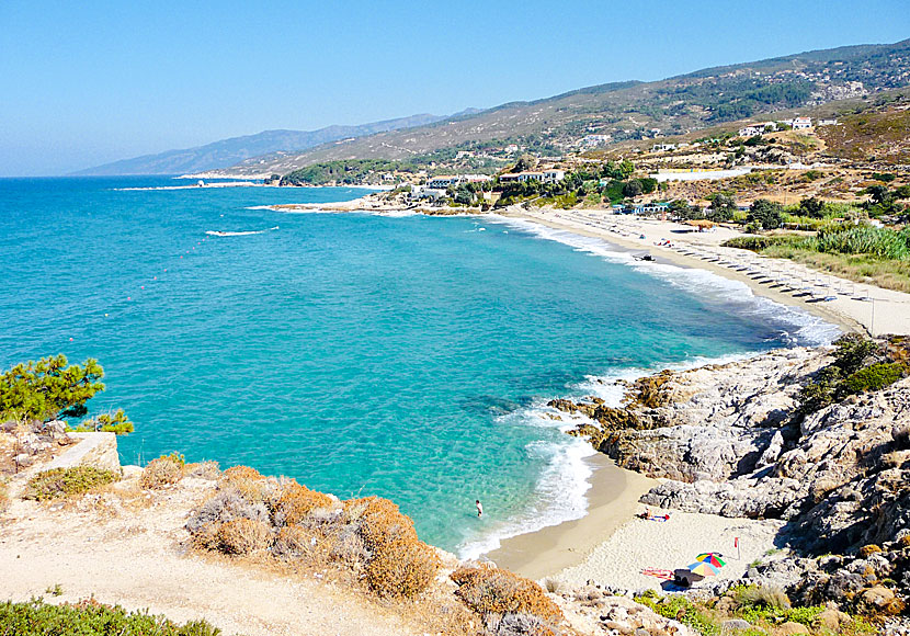
Beyond Sitia lies pretty villages and excellent beaches that tend to attract wild campers and visitors seeking a more authentic Greek atmosphere. The main draw here is the spectacular beach at Vai, one of the most popular day trip destinations on the island. It is famed for its palm trees that reputedly grew from seeds discarded by Roman soldiers. Now it probably has more sunbeds and umbrellas than gently swaying palms but hasn’t lost all of its appeal.
The South East Coast
As you head east from Ayios Nikolaos along the main road beside the Gulf of Mirabello, a road branches south across a narrow neck of land to Ierapetra. This is the largest town on Crete’s south coast and the centre of a rich agricultural area where fruit and veg is grown in a seemingly endless succession of polytunnels.
Ierapetra
Ierapetra has pretensions to being a tourist resort but is a somewhat windswept looking, workaday place with a long straggly beach of rough sand and pebbles, which is backed by a number of undistinguished hotels catering for package holiday markets. The most notable local excursions are the boat trips out to uninhabited Donkey Island (Gadhouronisi in Greek), which lies 10 km offshore and boasts cedar forests and sandy beaches.
To the west of Ierapetra, the main road runs through the pretty coastal village of Myrtos before heading inland towards the foothills of the Dhikti Mountains, which house the Dhiktean Cave where local legend claims Zeus, the king of the ancient gods, was born. Thereafter the road continues inland with a series of southerly cul de sac spurs heading towards quiet coastal villages.
Agia Fotia
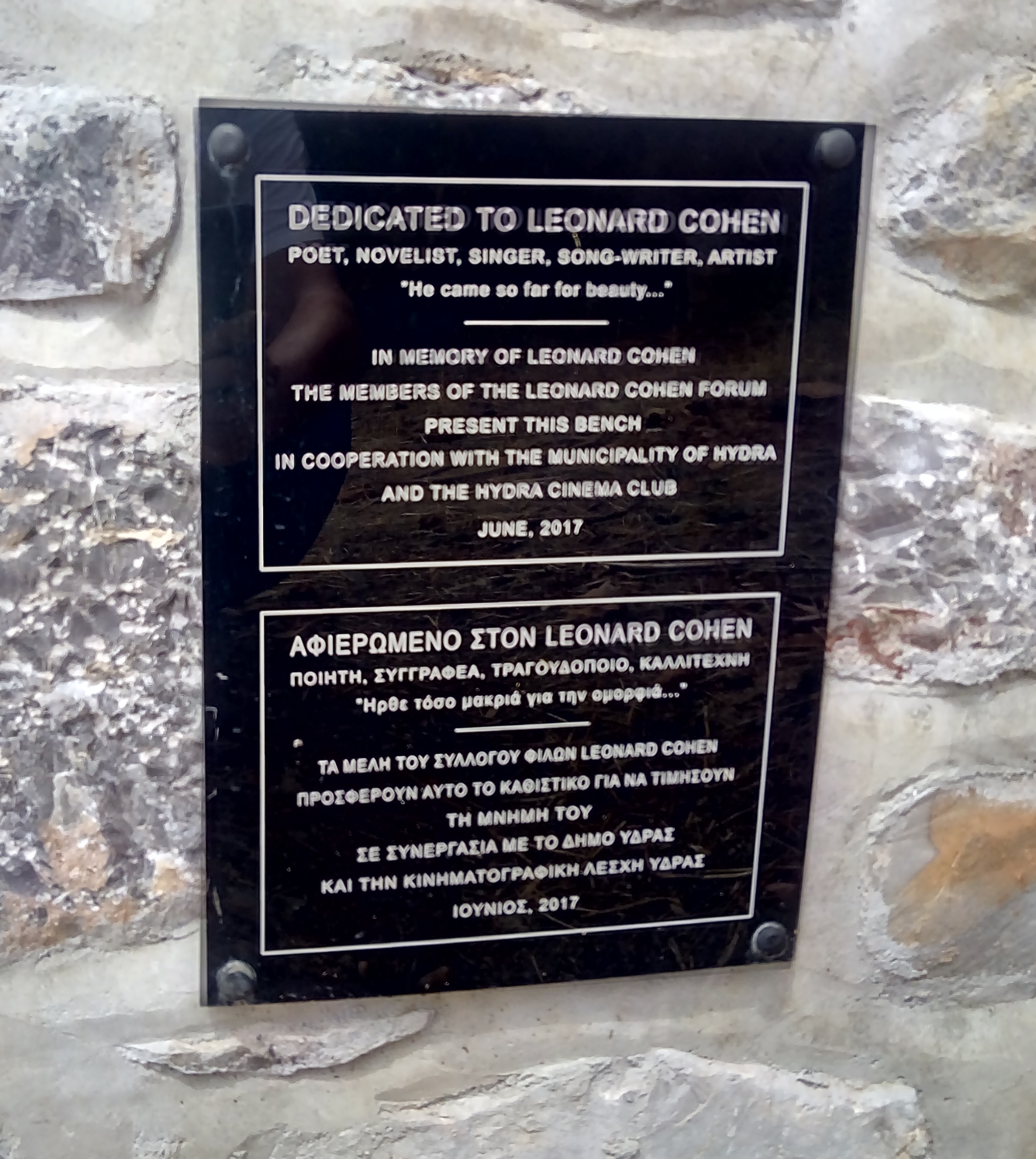
The road to the east of Ierapetra snakes its way past the aforementioned polytunnels to the turnoff for Agia Fotia, and its wide beach of rough sand. On my first visit to Greece in 1979, I spent a week wild camping here in the company of an army of German hippies who lit evening campfires and sang Bob Dylan and Leonard Cohen songs as guitars and joints were passed round.
At that time Agia Fotia had one rough taverna that served cold food and warm beer. It has developed a little since then and now has three or four tavernas, a few places to stay and some sunbeds on the beach. However, it is still far from being a fully fledged tourist resort and the beach retains more than enough space for everyone, especially as the hippies appear to have moved on elsewhere.
Makriyialos
A few kilometres further east, Makriyialos is the main resort village on this stretch of coast. It’s a bit of a sprawl with no obvious focal point other than the gently shelving beach of particularly soft sand which appears to make it very popular with families. There is a wide choice of places to stay and I enjoyed a tasty fish lunch in one of the beachside tavernas.
Beyond Makryialos, the main road runs through attractive mountain scenery to Sitia on the north coast. There is a turnoff to the coastal village of Xerocambos on the south eastern tip of Crete, after which another road continues north along the less visited east coast to the extensive ruins of the Minoan Palace of Zakros and the twin villages of Ano Zakros (inland) and Kato Zakros (on the coast). Both have a limited amount of visitor accommodation, which can fill up quickly in peak season. Paleokastro to the north is a larger farming village with a good infrastructure of visitor facilities and excellent beaches nearby.
The North West Coast
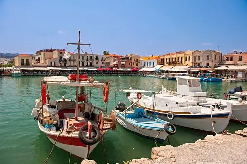
The north west coast is the most populated part of Crete with a major highway running west from Heraklion towards Rethymnon and Chania, the island’s third and second largest cities respectively. Both are predominantly modern cities with attractive historic areas.
Rethymnon lies about an hour west of Herkalion by bus and spreads out from a huge Venetian fortress that stands guard over its waterfront. A few steps inland is a beautiful area of narrow lanes full of tightly packed shops and tavernas. The feel of a Turkish bazaar is emphasised when you stumble across fountains and a mosque. This is where to head in the evenings although the quality of food can be questionable in some places.
Rethymnon
The city itself has a reasonable, sandy beach but most visitors on package holidays find themselves staying in the series of smaller beach side villages that stretch eastwards back towards Heraklion. A couple of these are large enough to be viable destinations in their own right, but many are little more than a large resort hotel surrounded by a few houses and tavernas (and inevitably car hire outlets). However, the beaches in this area are predominantly sandy if a little narrow, and there are regular bus services to and from Rethymnon itself.
Chania lies about 60 km to the west of Reythmnon and was the capital of Crete until the early 1970s. The main coastal road between the two passes through a number of resort villages of which Georgiopolis is the largest and best known. However, many other coastal villages have seen a fairly large scale expansion of apartment and villa developments in recent years.
Chania
The highlight of Chania is its waterfront with historic Venetian and Turkish buildings and a harbour where tavernas and bars line the quayside. The harbour itself can be quite noisy, especially if there is a cruise ship in port, but it is easy to find quieter corners in the back streets just inland or in the Kastelli area to the east, which tends to have more upmarket visitor accommodation.
To the north of Chania, the Akrotiri peninsula houses an important military base as well as the city’s international airport, which lies some 15km out of the centre. It’s also worth noting that ferries to Chania dock at Souda, 10km to the east. It is better served by local buses than the airport.
A number of guide books eulogise the north coast to the west of Chania. This area does boast some attractive beaches but the villages next to them often feel like ribbon strip developments with little character or charm.
Kissamos
The main coastal road runs on to the small, friendly town of Kissamos (also known as Kasteli), which has an attractive waterfront and acts as the gateway to the vast sandy and largely undeveloped beaches of Balos and Phalasarna. Regular ferries leave from just outside Kissamos for Kythira and the Peloponnese.
Balos Beach
If I had to pick between Rethymnon and Chania I would probably go for the former. It’s a bit smaller with a more obvious traditional or historic feel. However, it’s a hard call and I would certainly also consider Kissamos as an attractive but quieter option.
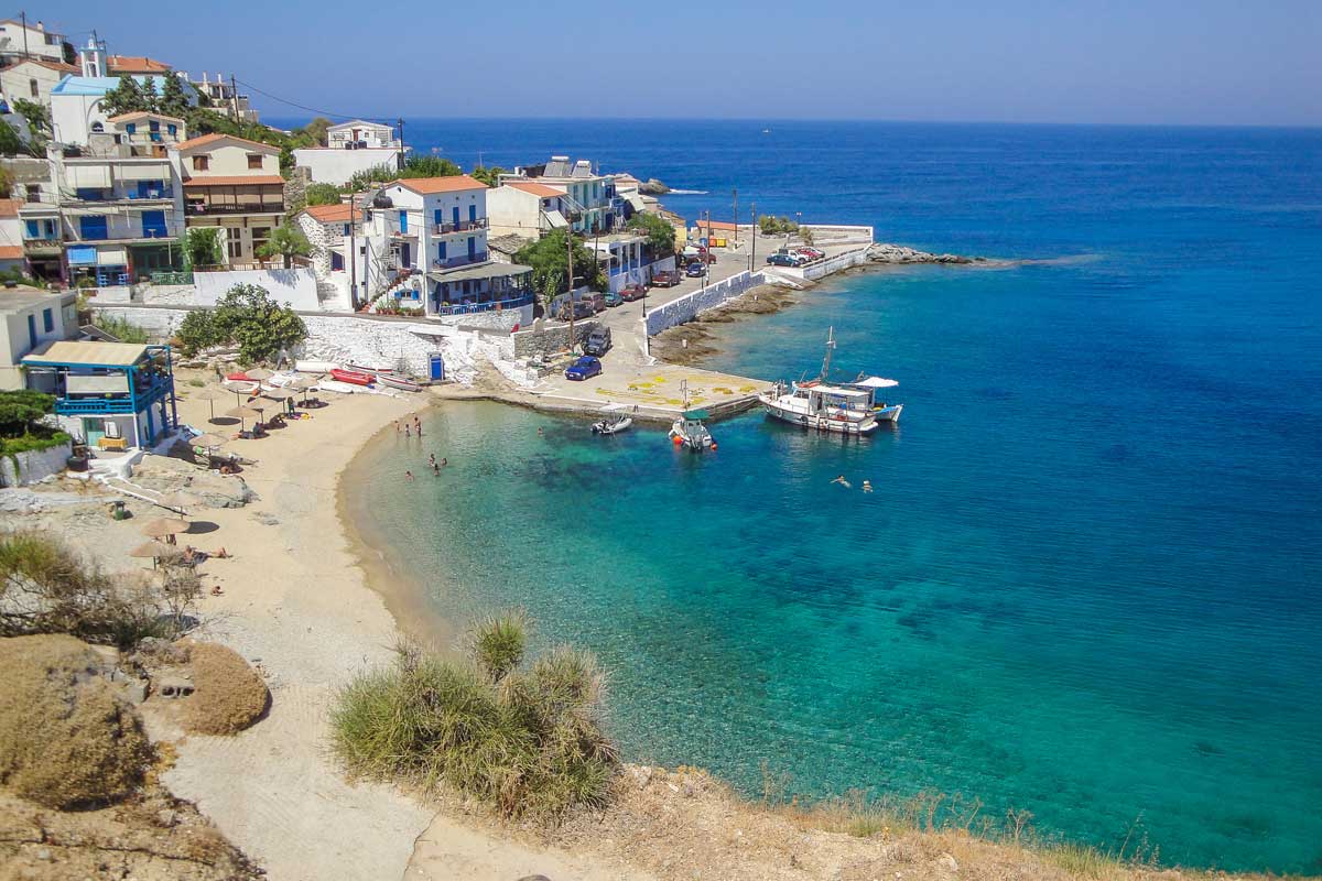
The South West Coast Part 1 – Sfakia and the Samaria Gorge
Loutro
The south west coast is probably my favourite part of Crete for its scenery, beaches and laidback, relaxed atmosphere. It is easily reached by regular buses from both Rethymnon and Chania and many of the villages are linked by enjoyable coastal ferry services.
Plakias
If heading south from Reythmnon, Plakias is probably the first coastal village you come to after a scenic drive through the mountains. Personally I found it a bit disappointing. It had the feel of a purpose built seaside adjunct to a larger nearby inland village and the much vaunted beach, although huge, was mostly composed of dull, greyish sand. I abandoned plans to stay there and jumped on a rather expensive taxi west along the spectacular coastal scenery to Hora Sfakion.
Hora Sfakion
The “capital” of the famed mountain bandit area of Sfakia, Hora Sfakion is a small village of about 300 souls clustered around a picturesque harbour area. It is the main port for ferries to the well known Samaria Gorge, which claims to be the longest gorge in Europe. The approach to the village is dominated by a large coach park catering for the day visitors to the gorge who pile through the village in the morning and flood back off the ferry in the late afternoon without barely looking at Hora Sfakion.
The village itself has a reasonable choice of places to stay, a good mix of bars and tavernas, a small beach and a memorial marking the site of the final Allied evacuation of Crete after the German invasion in World War 2, which left the locals behind to continue a covert, effective but costly guerrilla war.
Sweetwater Beach
The ferries to the Samaria Gorge stop first at the tiny village of Loutro which has no road link to the outside world. Loutro is a curve of about 30 – 40 buildings on a pebbly beach. Most of them house tavernas, bars and/or visitor accommodation. It’s picturesque, peaceful and quite lovely. A walk of just under an hour along the fairly rough footpath back towards Hora Sfakion brings you to Sweetwater Beach, a pleasant strand of sand and pebbles with a single taverna. When I visited, it was a summer home for a small colony of elderly Scandinavian nudists wild camping.
Ferries continue on from Loutro to Agia Roumeli, a slightly larger, road-less village that is the main southerly start and end point for exploring the Samaria Gorge, one of the most popular day trips in Crete. I didn’t get off the ferry here but I did watch several hundred visitors descend on the village, which looked fairly characterless and a bit like it only existed to cater for them. By all accounts the Gorge itself is spectacular but, if heading this way, I would plan to stay in Hora Sfakion or Loutra. Agia Roumeli looked like a place best passed through rather than stayed in.
Another Walking Group Pass Through Agia Roumeli On Their Way To The Samaria Gorge
The South West Coast Part 2 – Paleochora and Elafonissi
Paleochora
Paleochora is the largest town on Crete’s south west coast but, with a population of around 2,000, it is by no means a metropolis.
The town is beautifully situated on a headland between two beaches. To the east lies the harbour and the narrow Pebble Beach. To the west is Sandy Beach, a huge, wide expanse of soft sand that curves round a vast bay. This is the best place to head if looking for accommodation, which has the added bonus of awesome sunsets.
The town between the two beaches has a degree of tourism development but retains an authentic Greek atmosphere with a bit of an alternative/bohemian vibe in its organic tavernas and cafes, craft workshops and wellbeing centres. It’s laid back, relaxing and quite lovely.
Paleochora
There are regular buses (about three a day) to and from Chania and coastal ferry services link Paleochora to Hora Sfakion via Sougia, Agia Roumeli and Loutra. There are also ferries to the little island of Gavdos, 3 – 4 hours sail to the south.
The best known excursion from Paleochora is to Elafonissi, a tiny island that shelters a lagoon with bright turquoise water and stunning white sands. Elafonissi is regularly included in lists of the Top 10 beaches in the world and it’s easy to see why. The island itself is just a short wade off shore and is a protected nature reserve. It’s a quieter alternative to the sunbeds and tavernas encroaching on the main beach on the mainland.
Elafonissi
I visited Elafonissi in May when it was still relatively quiet. However, the huge car and coach parks on the adjacent mainland do highlight its peak season popularity and there are local concerns about the impact that growing visitor numbers are having on the natural environment. If you do visit, do so responsibly. It’s a special place. Please treat it as such.
ElafonissiSign
Elafonissi lies on the point where Crete’s south coast meets its largely unexplored west coast. I spent a day driving along the west coast and was entranced by its magnificent scenery which reminded me of the wild north coast of Madeira. There are successive, sleepy mountain villages; twisting roads down to quiet pebble beaches; and numerous signs for Slow Food tavernas and artisan producers.
Eventually the road joins the north coast at Kissamos from where it is possible to make a loop inland through the scenic White Mountains back to Paleochora. Do take time to get out the car to walk around a few villages and admire the scenery. There is little point in travelling along the road of life if you don’t sometimes stop to smell the roses (and eat the seafood).
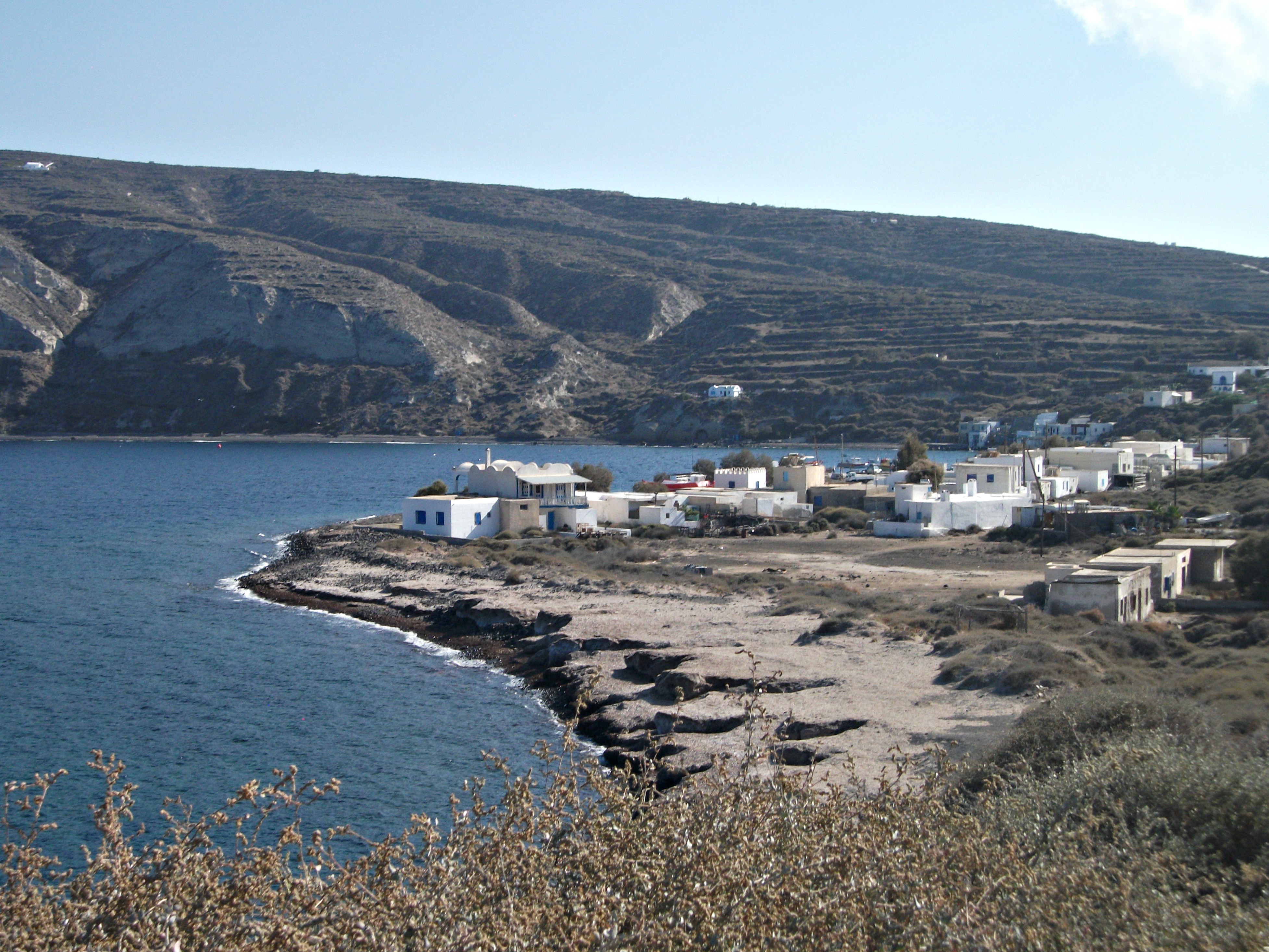
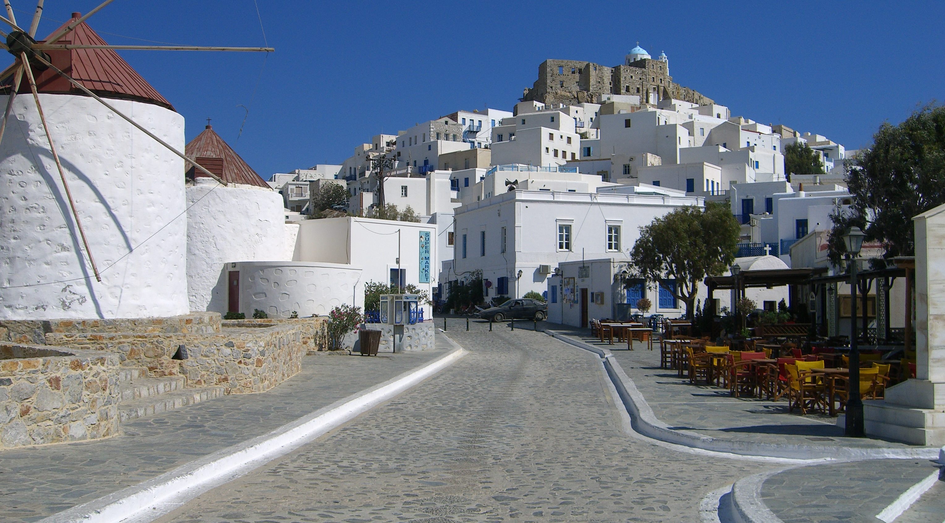
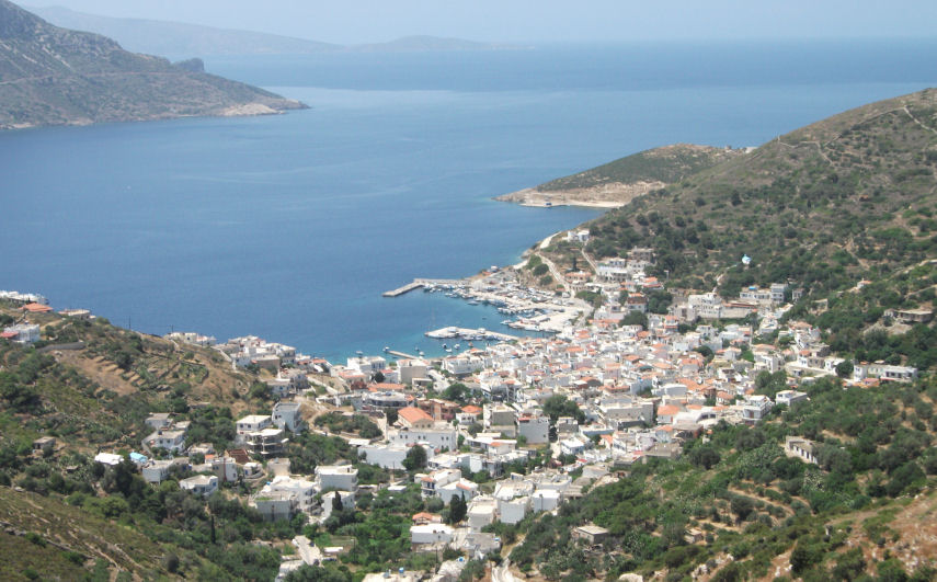
Gavdos
Visited in 2014.
Korfas
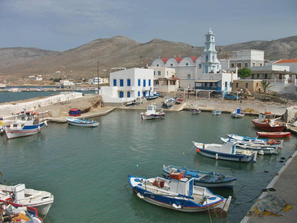
Little Gavdos claims to be the most southerly outpost of Europe, which it is if you don’t include the Canary Islands in the Atlantic. Located about 50km and 3 – 4 hours sail south of Crete across the often rough Libyan Sea, it is home to less than 50 year-round residents who somehow manage to spread themselves across 4 tiny settlements.
Ferries dock at Karave, where signs announce that recent harbour improvements have attracted millions of euros of funding from the EU. Karave itself has about four buildings: one with a shop; one with a taverna and one with holiday accommodation. That’s it really.
Sarakiniko
Gavdos attracts a significant number of young summer visitors who mainly head for the huge beach at Sarakiniko on the north coast. A minibus meets most ferries to transport them there. In May, Sarakiniko looked rather windswept and desolate with the occasional taverna or apartment block struggling to stay visible above the sand dunes. However, I was informed that it – and some other local beaches – have a pretty wild rave and drugs scene in peak season when hundreds of rich hippy kids from Northern Europe descend on the island and, in the words of one local, “go about naked, fuck in the open air, take drugs and leave their garbage and shit everywhere for us to clean up after they leave”. Deaths from drug overdoses are not unknown – allegedly.
I headed south for Korfas, a cluster of two tavernas with rooms, two other houses and an abandoned campsite overlooking another large sandy beach. Korfas is the main start point for the well-marked walking trail to Cape Tripiti, the most southerly point on Gavdos and, by local insistence, the most southerly point in Europe.
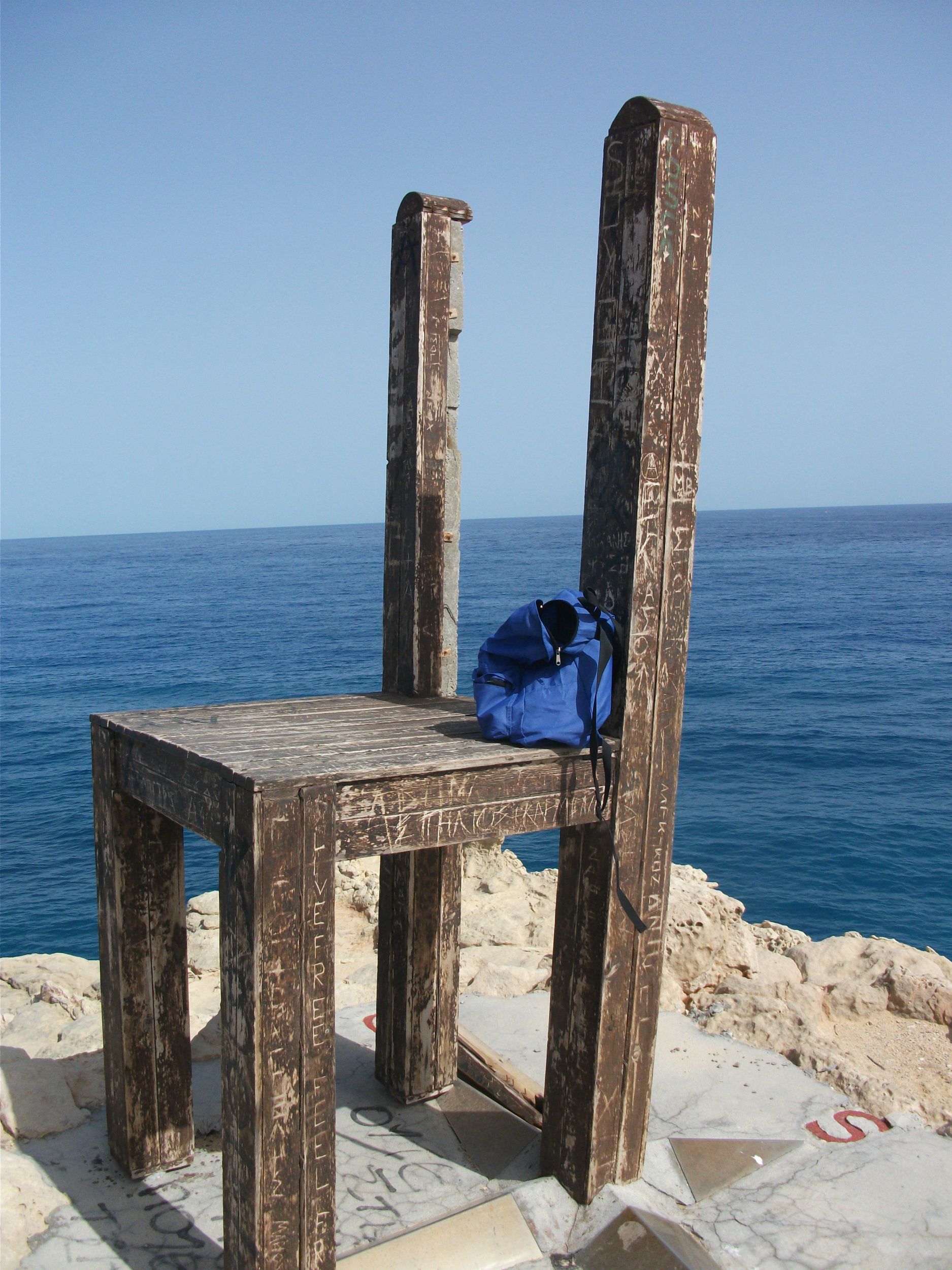
Cape Tripiti
Cape Tripiti is a wild, exposed pebble beach with a spectacular natural rock arch through which the sea foams. On the top of the arch is an oversized wooden chair on which to sit to admire the sea views. I was told this had been erected by a group of mysterious Russians who live in a house on the island and are reputed to be scientists from Chernobyl. Gavdos appears to attract strange people (or locals with unlikely but possibly true stories).
Russian scientists and naked, drug taking hippies apart, Gavdos does have a somewhat other worldly atmosphere, possibly due to its isolation. When I visited in May, only about half a dozen people got off the ferry with me and the island was comatose rather than sleepy and all the better for it. I was one of only two tourists staying in Korfas to complement the single family who stay there all year round. I was their first customer of the year and they opened up their rooms especially for me.
If you really want to escape the crowds, Gavdos off season is the place to go. There is excellent walking, great beaches and plenty of time and space to disappear and contemplate whatever you might wish to consider.
The Cyclades islands tend to provide the best known and most iconic visual images of Greek island destinations. In particular, Santorini and Mykonos feature in every Greek calendar and the island group, as a whole, is most noted for its white cubist houses, blue domed churches and prominent windmills. However, there are a lot of islands in the Cyclades and a great deal of variety between them.
The group gets its name from the notion that they circle the sacred island of Delos, nowadays a small, bare, uninhabited rock that was a key commercial and religious centre in ancient times. Its extensive ruins make it a major day trip destination from its nearby neighbours, Mykonos in particular. However, Syros is the modern day administrative centre of the group, although Naxos is its largest island.
The Cyclades are criss-crossed by numerous ferry and hydrofoil routes that make them ideal for island hopping. Some are only 1 – 2 hours sail from the mainland; others can take the best part of a day to reach if they are located at the end of a long multi-island ferry route from Piraeus.
Mykonos and Santorini have busy international airports and have seen a large recent growth in cruise ship visits. Milos, Naxos, Paros and Syros have local airports with one or two flights a day to and from Athens and the odd connection elsewhere in Greece.
Santorini and Mykonos may be the most photogenic islands of the group, but they are far from being unspoiled, tranquil idylls and are struggling to cope with the sheer weight of visitor numbers that now descend on them during a lengthening peak season.
Ios was once the all night party island of the group. However, it has quietened down a little in recent years, although its visitor profile is still much younger than most of its neighbours.
Naxos and Paros also attract significant numbers of visitors, which they are large enough to absorb without losing all of their traditional atmosphere. Folegandros and Sifnos are growing in popularity with the wealthier end of the Greek visitor market, while Tinos remains an important site of Orthodox Greek Christian pilgrimage.
Amorgos is an island of which connoisseurs tend to speak in awe, especially if they are keen walkers, while Milos offers a variety of landscapes and an appealing mix of tourism and every day working life. Andros and Kea, the nearest islands to the mainland, are popular weekend destinations for Athenians.
The greatest tranquillity can be found in far flung Anafi, sleepy but somewhat dull Kythnos, under rated Sikinos, or the Lesser Cyclades, a group of four attractive small islands lying to the south and east of Naxos.
Their sheer number and variety ensure that the Cyclades have something for every type of visitor. However, a bit of online research is a good idea to identify which of the group are most likely to meet individual requirements and expectations.
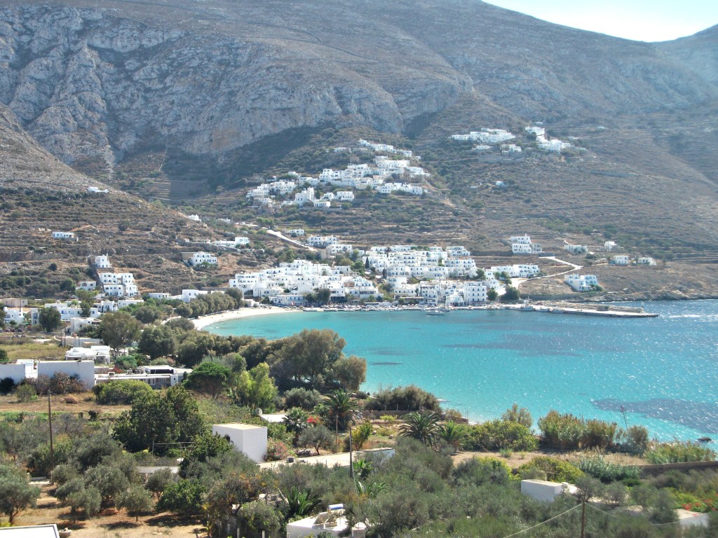
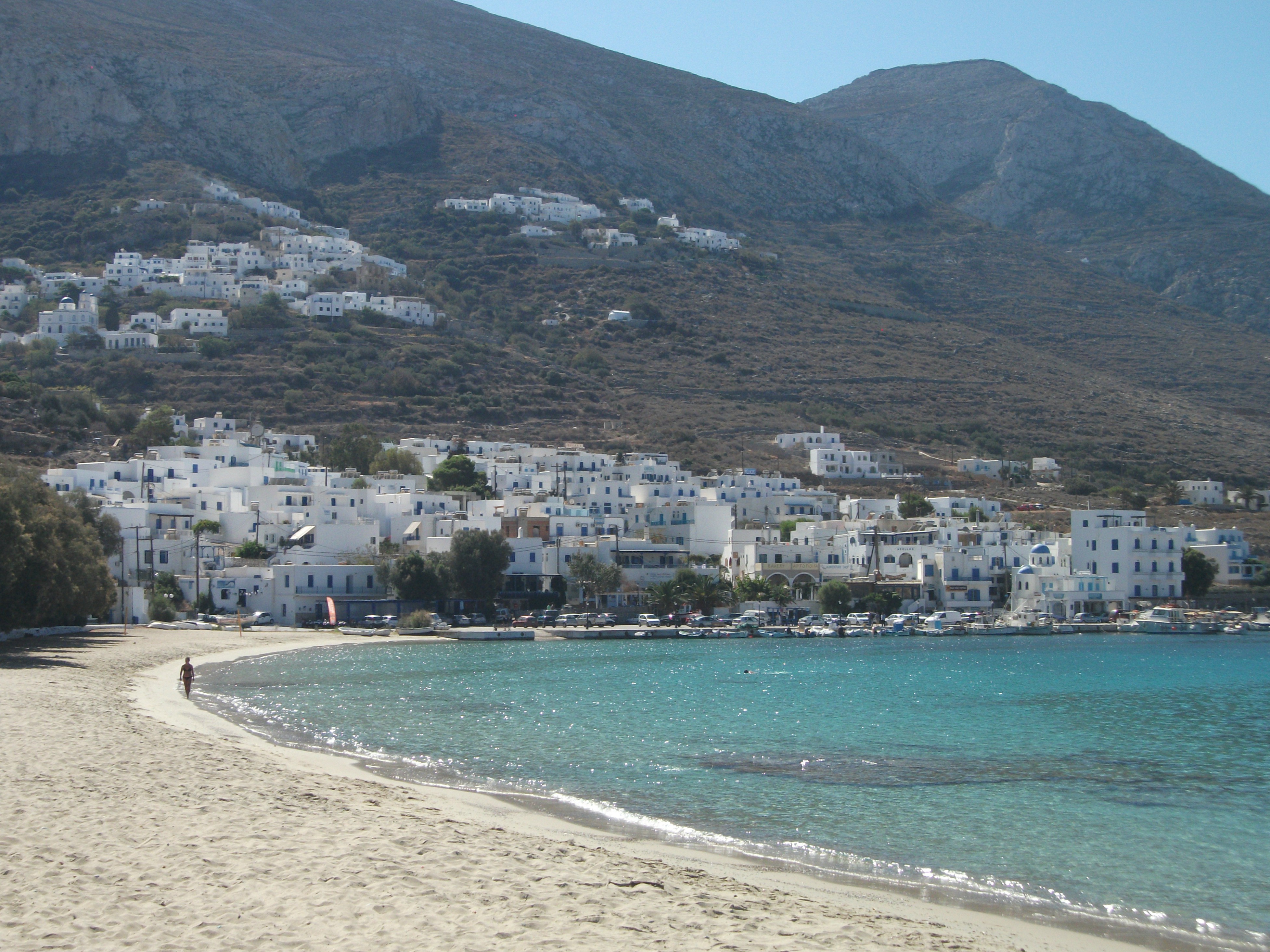
Amorgos
Visited in 2016
Large and scenically spectacular with unobtrusive but limited tourism development. Getting there can involve a lengthy ferry journey, but it’s very much worth it.
Aegali
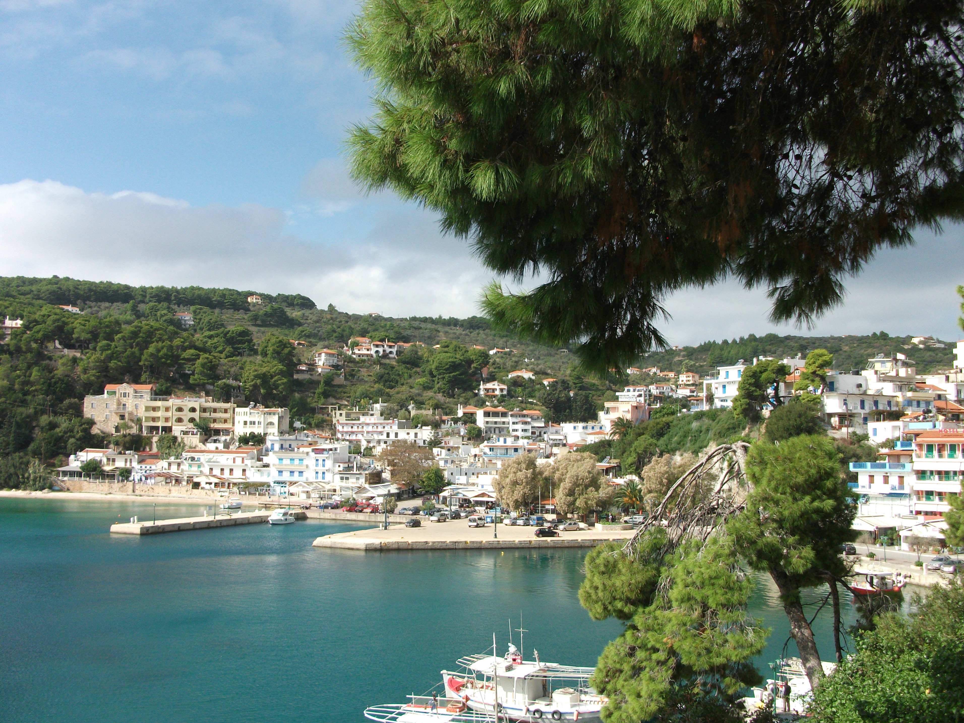
It took me 37 years of visiting Greek islands before I finally got round to Amorgos, by which time it had attained almost mythical status in my mind. It’s an island that many people I have spoken to over the years described with enthusiasm and a sense of awe. The classic “Greece as it used to be” sort of island, particularly loved by older couples keen on walking. As I entered that particular demographic, I decided it was time to find out for myself what all of the fuss is about.
Amorgos is not a particularly easy island to get to. There is no airport and ferries from Piraeus can take over nine hours with numerous stops at other islands along the way. Even travelling from Naxos, it’s nearest large neighbour, can take over 5 hours on the redoubtable Express Skopelitis ferry, which usually stops at most of the Lesser Cyclades en route. However, this friendly local ferry is the best and most interesting way to travel to Amorgos. Why hurry anyway? You just miss out on the sights, smells and sounds of Greece.
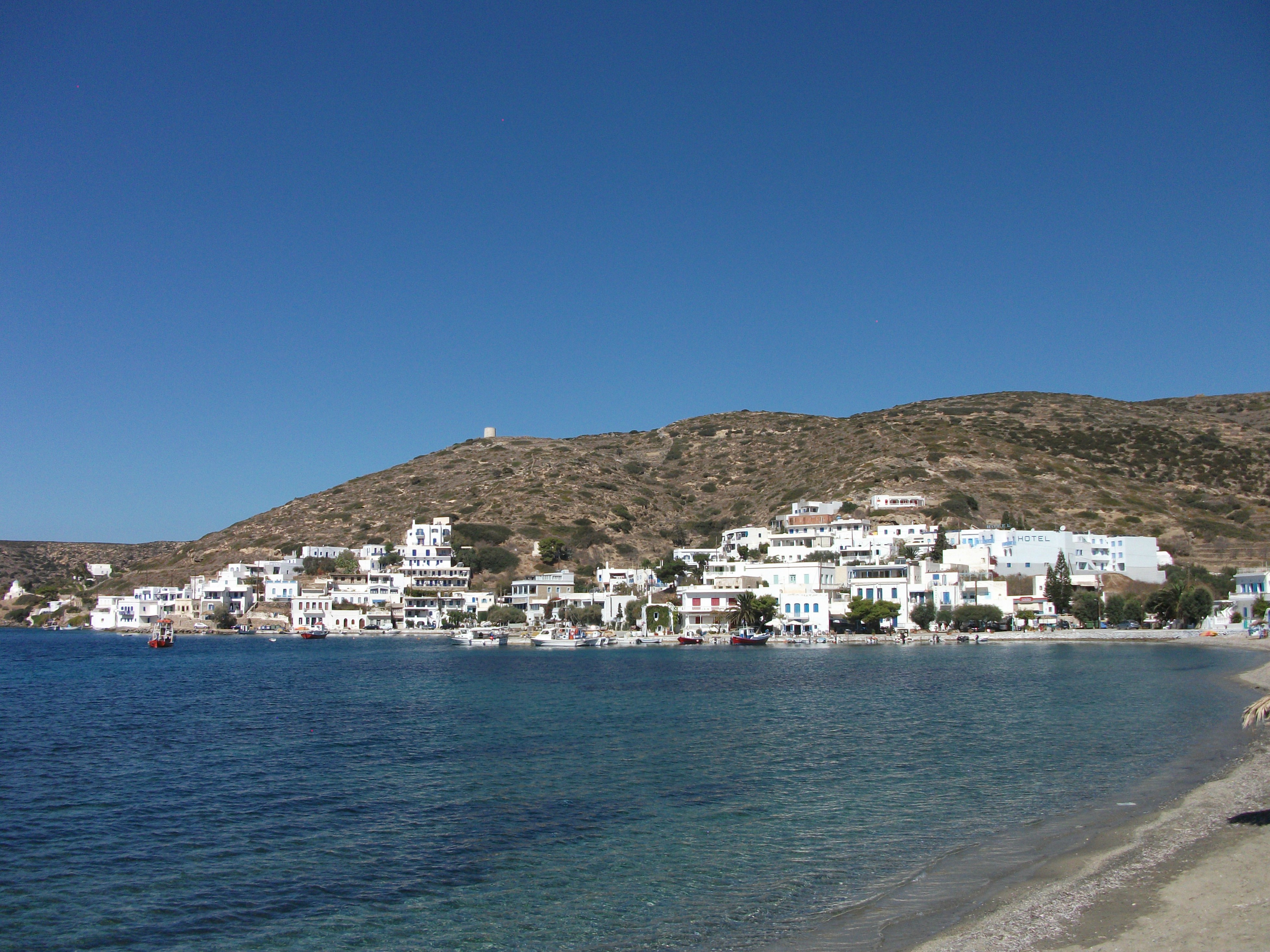
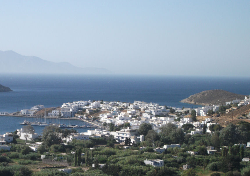
Katapola
Amorgos is a long, thin island with a choice of two ferry ports – Katapola in the south and Aegali in the north. Most, but not all, ferries stop at both. Katapola is the larger of the two, spread out in two distinct districts on a wide circular bay ringed by high mountains. Aegali is a bit smaller but has a much better beach and the added bonus of a trio of attractive mountain villages within easy walking distance. I stayed in Aegali and loved it.
Aegali
In particular, early evenings were a joy as locals and visitors converged to view spectacular sunsets from a line of bars that tumble up from the harbour. Thereafter everyone disperses to small tavernas dotted around the village where one of my evening meals was only slightly spoiled by the unfortunate proximity of the local chain smoking society at the next table. The concept of no smoking in covered public places is still somewhat alien in many parts of Greece.
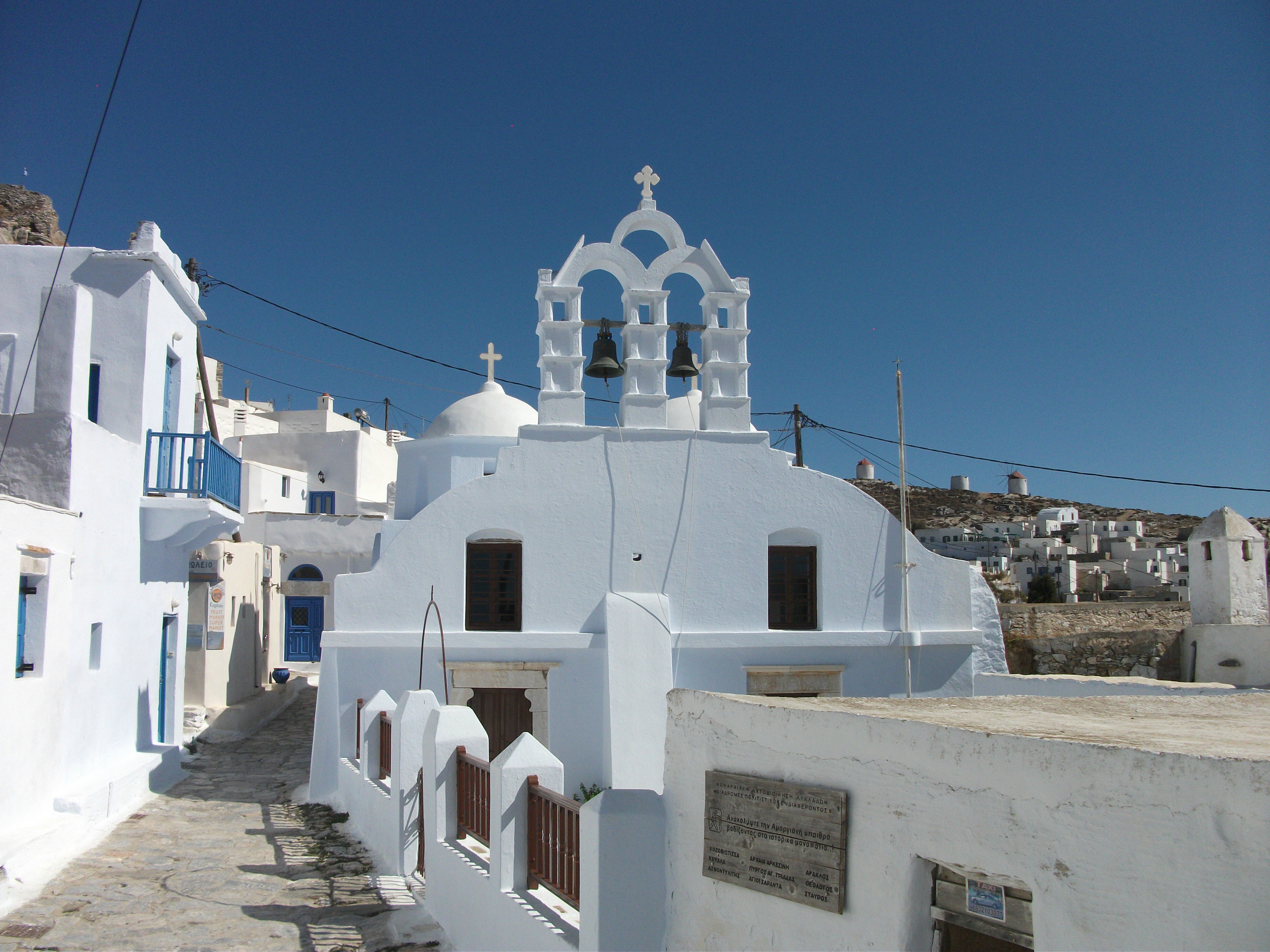
Chora
There are regular buses between Aegali and Katapola as well as car and scooter hire in both. The island’s Chora, or capital, lies between the two and is a charming warren of paths and lanes that belies its rather rough initial appearance. It’s well worth an hour or two of anyone’s time. South of Katapoula, the main road continues for a few more kilometres past sleepy farming villages and quiet, undeveloped beaches before it just peters out at sandy Paradissa Bay.
Hozoviotissas Monastery
The island’s best known visitor attraction is the gleaming, white washed monastery of Hozoviotissas, which clings to a towering cliff and is open daily to visitors. It’s a fair climb up from the small car park, but the sea views reward the effort.
Amorgos is quite simply a beautiful island and great walking country with networks of well-marked paths and trails. It is indeed Greece as it was 20 – 30 years ago but with better food and sanitation. It can be a bit of pain to get to with long ferry rides, but is more than worth the effort. Highly recommended. Take time to explore it fully. It’s not a place to rush in and out of.
Anafi
Visited in 2014
Barren,small, remote and sleepy. An island for those who want to experience “Greece as it used to be”. Large, undeveloped and uncrowded beaches.
Klissidi Beach
Lonely little Anafi is probably the most remote of the Cyclades, lying at the southern edge of the group almost 12 hours sail from Piraeus and 4 hours from Crete to the south. Santorini, its nearest neighbour, is 90 minutes to the west and the difference between the two islands could not be more marked, despite them sharing the same barren volcanic landscape.
Anafi is home to around 300 people, most of whom live in the Hora, a hill top village a couple of kilometres inland from the dusty, run down port of Ayios Nikolaos. Hora is an appealing little place where white washed houses gleam against the dull brown soil around them. The best place to view it is from the little church at the top of the village, from where the expansive views across the barrel shaped roofs of houses, tavernas and shops are only slightly spoiled by intrusive power lines.
Hora
There is a reasonable choice of accommodation in rooms scattered around the village and, in May, Hora is the kind of place where you see the same faces every day and quickly get on talking terms with total strangers. Anafi is an island that has hard-core, committed devotees who return year after year. The Swedish physiotherapist in the room next to mine had been coming for over 30 years and I met an elderly German couple who could date their first visit back to the early 1970s.
There is a good network of walking routes across the island but, for the less active, the beaches are probably the main attraction. The nearest to Hora is Klissidi, a 400 metre stretch of soft golden sand that is a short walk from Ayios Nikolaos. There are a few rooms to rent and couple of tavernas at the beach which I had all to myself for a few hours until the afternoon arrival of three other people forced me to flee the crowds.
Roukounas Beach
From Klissidi, a paved road strikes east along the south coast of the island and through a landscape of cacti and prickly pears. It passes a series of completely undeveloped and deserted sandy beaches of which Roukounas is the longest and most popular, particularly with wild campers. After almost two hours of walking the road stops at the monastery of Zoodhohou Pigis, where a ruined ancient temple is incorporated into the main building. The island bus occasionally makes it out this far in peak season and, when I visited, I tagged on to a small group of French day trippers from Santorini to listen in on the history of the monastery.
Zoodhohou Monastery
Beyond Zoodhohou Pigis a path leads to another little monastery about an hour’s walk away at the top of an awesome cliff face that my French tour guide questionably claimed is the second highest in Europe. With my vertigo I gave it a miss, although the views from the top across the well named Monastiri beach must be spectacular.
Anafi
It is possible to day visit Anafi from Santorini about once a week in peak season. However it deserves a longer stay. Ferries tend to arrive and leave at odd hours of darkness, but accommodation providers get out their beds and drive down to the port to pick up and drop off visitors. Night life is limited to conversations in tavernas which occasionally have some live Greek music. But you don’t come to Anafi for the night life. You come to unwind and relax and you can do that very well.
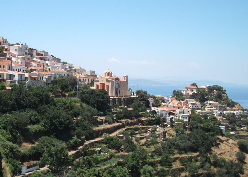
Andros
First Visited in 2010. Most recently visited in 2022.
The most northerly and second largest of the Cyclades. A short ferry ride from the mainland, with a particularly attractive main town.
Andros Town
Andros is the second largest and the most northerly of the Cyclades islands. It is also one of the easiest to visit with four or five ferries a day making the 2 hour crossing from the pleasant mainland port of Rafina, a less frantic and more manageable alternative to Piraeus with regular direct bus links from Athens’ airport and city centre. Almost all the ferries continue on to Tinos and Mykonos and some voyage on to additional, more southerly islands.
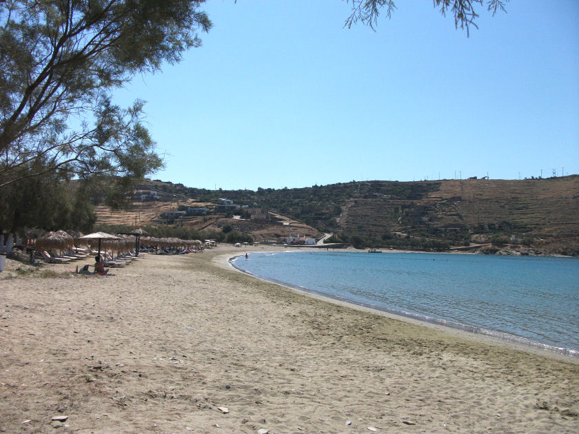
Gavrion
The island ferry port of Gavrion lies in the north west of the island and is a busy little village with countless car hire outlets and numerous travel agencies selling ferry tickets. There are also plenty of places to stay, eat and shop for souvenirs, as well as attractive and relatively quiet sandy beaches within walking distance.
The north west corner of Andros beyond Gavrion is wild, remote and little visited. Most visitors head east along the main coast road to Batsi, which is probably the best known beach resort on the island.
Batsi
I’ve been to Batsi twice and didn’t really take to it either time. On my first visit in 2010 I felt it was trying for an upmarket, alternative, bohemian vibe that it didn’t deliver. On my second visit in 2022 the new studios and apartments clambering up the hillsides reminded me of the soulless purpose built resort developments you find in parts of the Canary Islands. I’m sure Batsi has its devotees, but it’s not for me.
From Batsi the main road continues onto Andros Town, the island’s Chora or capital, centrally located on the east coast. It’s 33 kilometres from Gavrion, to which it has four or five buses a day each way. Buses generally link into ferry arrival and departure times and the journey takes just over an hour, much of that time being spent squeezing slowly through the narrow streets of the attractive hill villages on the approach to the Chora.
Andros Town
Andros Town itself is one of the prettiest towns on the Greek islands. It spreads out from a rocky promontory with a huge, expansive beach to one side. It’s full of fine neo-classical buildings, leafy squares and flagstoned streets and alleyways that host a plethora of boutique style accommodation, upmarket shops and pavement cafes.
The town’s archaeological museum is one of the best of its kind that I have visited in Greece with clear and detailed information on its many exhibits in both Greek and English. The only thing that lets the town down is its public toilets at the bus station, which are simply disgusting.
There is another small town called Korthio about 5 kilometres to the east of the Chora. It has a pleasant location on a wide bay, but little else to detain visitors for too long (although some of its tavernas have a good reputation).
Andros is an island I would recommend to people who are still fairly new to Greece. It lies somewhere between the biz and buzz of the large package holiday islands and the quiet solitude of small, more remote options. It is large by Greek standards with lots to see and do and plenty to entertain visitors on an extended stay. However, I would suggest staying in Andros Town or Gavrion in preference to Batsi.
Antiparos
Visited in 2017.
The smaller and quieter neighbour of Paros with an attractive main village and a large and interesting cave complex.
Antiparos Village
Antiparos is Paros’ smaller westerly neighbour in the central Cyclades. It has started to attract growing visitor numbers in recent years as people spread out to look for new islands to explore. However, it is probably still primarily a day visit destination from its parent island and that is how I came to it.
The main access is from the small port of Pounda on Paros from where regular ferries plough back and forth on the 15 minute crossing to the main village that shares the name of the island and is also home to the majority of the 1,000 or so local residents.
Antiparos village is a charming jumble of flagstoned streets and whitewashed buildings with a varied choice of places to stay, eat and shop. Taverna menus appeared a bit more upmarket and organic than on many islands and the village has a feel of well maintained, quiet prosperity. It reminded me of a slightly more touristy version of Fourni Korseon in the North East Aegean.
The Great Cave
The premier must-see attraction on Antiparos is the Great Cave, located inland about 10 kilometres south of the main village. This is a very impressive series of rocky chambers large enough to fit in several hundred people at a time. It is open daily in the summer and regular buses run to it in peak season. Arriving in the quieter spring period, I hired the island’s only taxi to get there and strolled back along the paved road past fields and road verges full of colourful wild flowers waving in the cooling breeze.
Psaraliki
Antiparos is also noted for its sandy beaches that start at Psaraliki, just to the south of the main village, and continue down to the small hamlets of Soros and Agios Georgios at the very south of the island, both of which have a few tavernas and rooms for rent. Excursion boats run there from both the main village and Parikia on Paros and often continue on to the uninhabited little island of Despotiko that lies just off Agios Georgios.
People to whom I have spoken talk of Antiparos as a quieter, less developed and more authentic alternative to the larger and busier Paros, which itself is hardly a throbbing metropolis. I can imagine that it may get somewhat overrun by day trip excursion boats in peak season, but, at other times of year, it remains sedate and peaceful. Next time I am in the central Cyclades, I may well give it a longer visit.
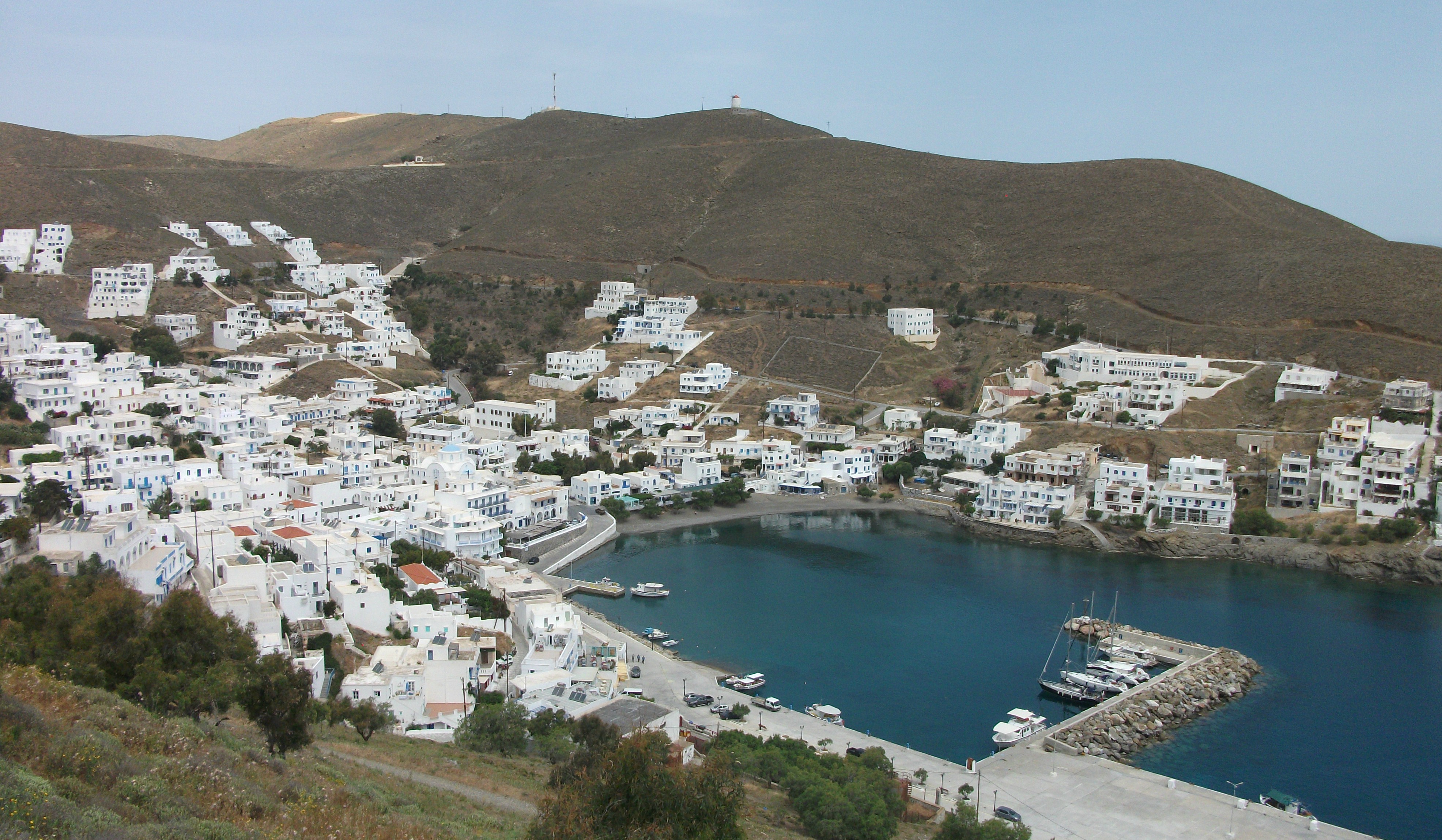
Donoussa
First Visited in 2016. Most recently visited in 2017.
One of the Lesser Cyclades islands. Small and quiet with limited tourism infrastructure but spectacular beaches. An island for escapists.
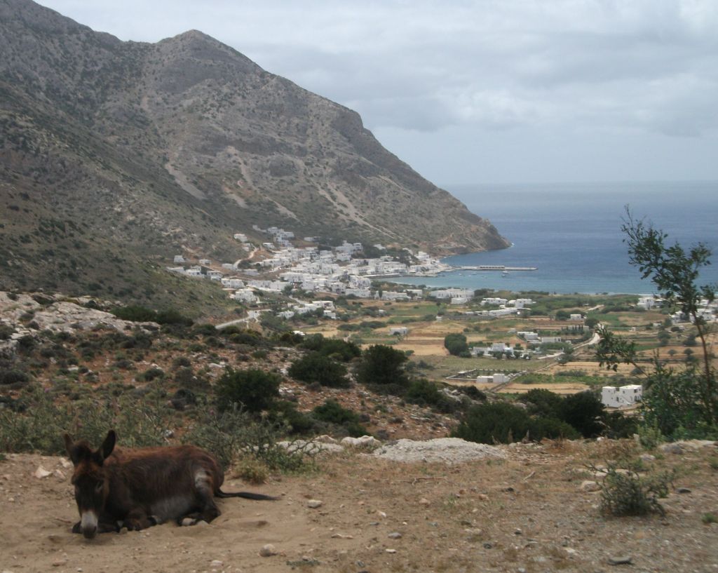
Stavros
Sleepy little Donoussa is the most remote and least populated of the four Lesser Cyclades islands that lie to the south and east of Naxos. I first came upon it as the local Express Skopelitis ferry stopped there on its way to Amorgos. I liked the look of it enough to make a day trip from said Amorgos. That tempted me to revisit the following year and stay for a few days to explore it more fully.
Donoussa is a roughly circular island with just over 100 permanent residents who somehow manage to spread themselves over 3 small villages. The port of Stavros is the largest and arguably the prettiest. A beach of perfect soft sand and shallow turquoise water circles round from the little ferry quay to the nearest headland which offers a surprisingly varied choice of hotels and rooms for rent. There are a couple of small mini-markets, one or two tavernas (depending on if they are open) and a couple of bars that act as the main focal points of local activity. One sleepy bar on the quayside is the gathering place for the older generation, while a music bar round the corner attracts the youngsters looking for what passes for evening action on Donoussa.
I left Donoussa bound for Astypalea on a 2am ferry and ensconced myself in the music bar to await its arrival. By midnight I was the only customer left and the owner closed up and wandered off after checking if I wanted the music left on and inviting me to help myself to beers from the cool cabinet and to leave any payment on the bar.
Kalotaritissa
From Stavros a number of somewhat confusingly waymarked footpaths spread out across the island. Once I finally found its start point, I tackled the longest round island trail that starts off by climbing along a ridge towards the island‘s highest point before dropping steeply down a series of rough terraces to Kalotaritissa, a tiny coastal hamlet that appeared to populated solely by chickens.
Kendros
From there it was a an easy couple of hours walk back to Stavros along a paved road that passes the rather dusty and run down village of Mersini and the glorious, wide sandy beach of Kendros, which is favoured by nudists and has a single taverna where friendly service just about mitigates for the mediocre food.
Donoussa Sunset
On Donoussa I stayed at the wonderful Ammos Studios in the centre of Stavros, two minutes walk from the ferry quay and ten meters from the beach – perfect for an early morning swim as the sun comes up. Donoussa is a real get-away-from-it-all island that you will probably want to go back to again and again. Don’t miss it.
Folegandros
Visited in 2016
A bit like a much quieter and more sedate Santorini. Increasingly popular with Greek visitors.
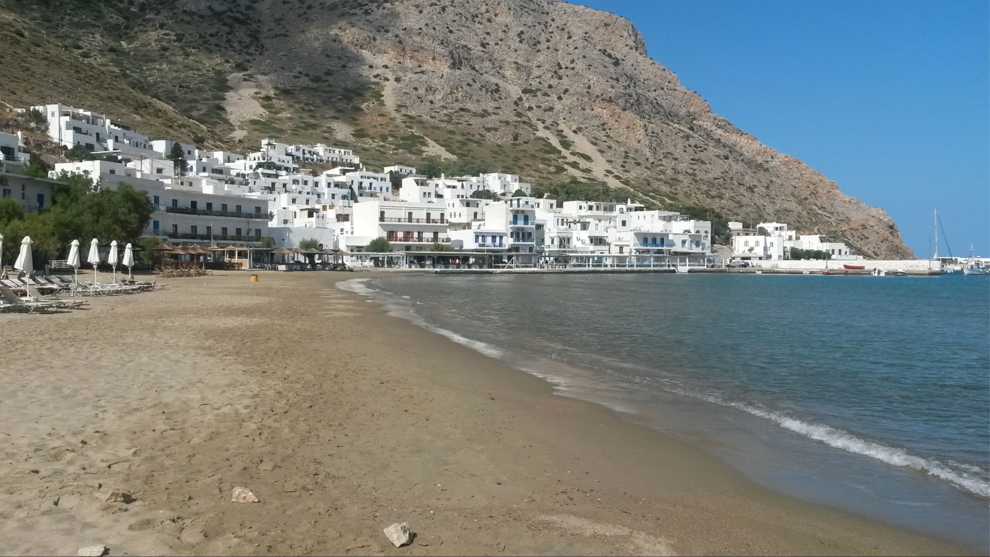
Hora & Kastro
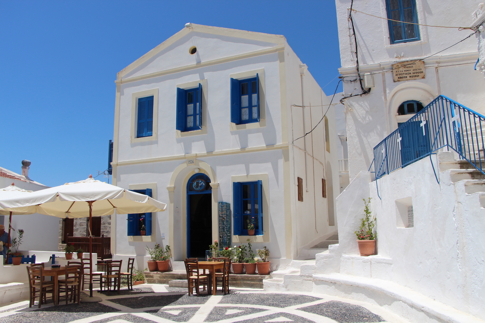
Located in the southern Cyclades roughly halfway between Ios and Milos, Folegandros is a small, attractive island with a deservedly growing tourism sector. That said, when I visited in October there were probably no more than two or three dozen visitors on the island.
The undoubted highlight of Folegandros is the Hora, located on the edge of high cliffs that give dizzying drops to the sea below – a bit like Santorini on a smaller scale without the crowds, but with the same spectacular sunsets.
The defensive Kastro in the centre of the village is particularly atmospheric but the rest of the Hora is equally appealing with a maze of paths and lanes leading to little squares filled with tables from surrounding tavernas and overlooked by surprisingly upmarket jewellery, clothing and gift shops. Evenings are quiet and relaxed and best rounded off in one of the local bars eavesdropping or joining in on local gossip as music softly plays in the background.
Chora at Night
There are regular buses between the Hora and the ferry port of Karavostasi, but don’t expect them to necessarily align with ferry arrivals and departures. I arrived to find I had missed the bus to Hora by 5 minutes and had a 2 hour wait until the next one. I started walking and thankfully was picked up by a local who also happened to let rooms in a rather splendid mansion on the edge of the Hora.
Karavostasi
At first glance Karavostasi appears to have little to offer other than a rough pebble beach and some undistinguished studio accommodation. However, a longer stay warms you to its understated charms and friendly tavernas. The beach at Livadi, about a ten minute walk away, is one of the largest on the island and has its only official campsite (closed in October) but not a lot else.
The other main village, Ano Meria, lies about 4 kilometres north of the Hora and is a pleasant and easy walk, although I feel I must have missed something as it seemed to have no real centre to speak of. On the way there a road turns off to the sands at Angali, probably the most popular beach on Folegandros with some rooms and a couple of tavernas. Buses run to it from Hora, but not very often out of the main season.
Angali
Folegandros is very pretty with a spectacular coastline and a hinterland where farming still takes precedence over tourism. The Hora is quite simply delightful and very much the place to stay. Prices are maybe a little higher than elsewhere, reflecting its upmarket aspirations. However, if you like your Greek island escape to have a touch of understated class, Folegandros is the place for go.
Ios
First Visited in 2014. Most recently visited in 2016.
Once the young, noisy party island of the Cyclades. Has calmed down a little over the years but still predominantly attracts younger visitorsfor its beaches and night life.
Mylopotamos
When I first came to Greece in 1979, Ios had a reputation as a loud, all night party island where happy hours and cheap alcohol fuelled short and drunken sexual liaisons. Being a shy and sensitive type, I naturally avoided it.
Today, Ios has shed much of its wild reputation but is still an island that attracts a largely young clientele. I arrived there from Anafi, where I was possibly the youngest visitor on the island, to find myself very much amongst the oldest of the old farts on Ios.
Ios is a large, well connected island with regular ferries and hydrofoils in all directions. Just about everyone lives or stays in one small corner on the west coast where the port of Gialos, the Hora and the beach resort of Mylopotamos are all within comfortable walking distance of each other.
Gialos
Gialos is the quietest option for visitor accommodation. Its long, hard sand beach is backed by an array of hotels and studios and there is a good choice of tavernas, cafes and minimarkets. I generally stay here, partly for the short walk to early morning ferries and partly for the more relaxed late evening atmosphere which is welcome after a few night time hours in the Hora.
There are regular buses up to the Hora, or it is a 20 minute uphill walk along a footpath that bisects the main road. The Hora is a very picturesque village of meandering lanes that appears sleepy during the day and bursts into life at night when every type of cuisine is on offer and music blares out of more bars than any sensible person could visit in a fortnight.
Chora
I had one entertaining evening in a Thai restaurant where a very drunk, loud and foul mouthed American “jock” on the pull was dragged screaming out into the street by another customer bent on beating the crap out of him for hitting on his girlfriend. However, try hard and you can find quieter, slightly more sedate corners hidden away on the back streets.
Mylopatamos
Mylopatamos is a magnificent sandy beach with a number of camp sites, lively tavernas and bars, and watersports centres that seemed to be staffed almost exclusively by Australians. I’ve only visited Ios off season, but I imagine the beach at Mylopotamos is spacious enough to accommodate all but the largest peak season crowds in relative comfort if not tranquillity.
The rest of Ios is still a mystery to me. There are few paved roads but excursion boats and buses run to other remoter beaches with tavernas and watersports. Homer’s tomb is allegedly located at the north of the island, but it’s unlikely that the ruins there date back to the times of the ancients.
I find Ios a good choice for a couple of nights at a time when I feel a need for a livelier atmosphere and something other than calamares and octopus on the menu. It’s great for a beach holiday and will particularly appeal to teenagers and the younger generation, but don’t expect too much quiet evening relaxation.
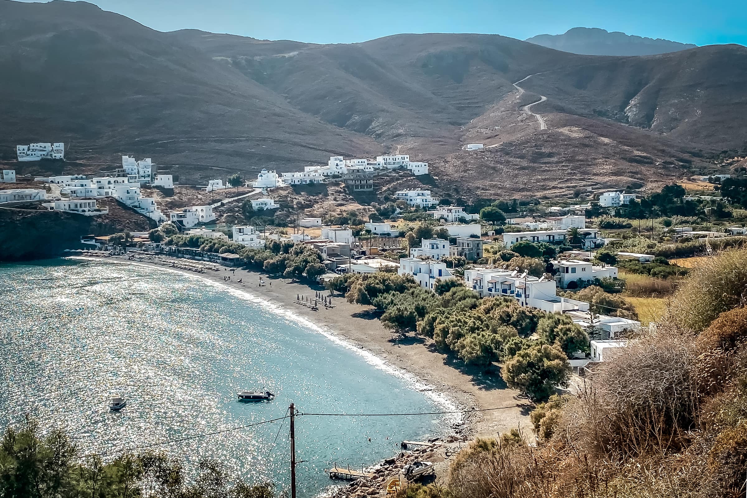
Iraklia
First Visited in 2007. Most recently visited in 2017.
One of the Lesser Cyclades. Small, quiet and pretty. Only a short ferry ride from it’s large neighbour, Naxos.
Iraklia
Iraklia is the nearest of the four Lesser Cyclades islands to Naxos and home to just over 100 permanent residents. The local Express Skopelitis ferry takes about an hour and half to travel from Naxos Town and runs on most days. There are also a few larger ferries to and from Pireaus most weeks.
In addition, it is possible to visit Iraklia on a day trip excursion boat from Naxos and Paros that runs two or three times a week in the main season. However, this only gives you an hour or so on the island before it continues on to nearby Koufonissi.
Agios Georgios
The port of Agios Georgios is the larger of the two villages on the island. It’s a spread out kind of place with a minimarket, a few tavernas and about half a dozen accommodation providers renting out studios and rooms. I stayed at Angelos Rooms, which I can wholeheartedly recommend for location and comfort, as well as proximity to the owners little café/snack bar across the road which serves up excellent breakfasts.
Livadi
The beach in the heart of the village has soft sand, clear water and shady trees. However, a 15 minute walk along the only paved road on the island brings you to the larger Livadi beach where there are a couple of very seasonal tavernas and some more rooms for rent. The beach is overlooked by an abandoned village of the same name that stands on the hillside above it.
The paved road continues on to Panagia (also known as Hora), the only other village on the island. This is something of a one street, one man and one donkey place with little to detain visitors. However, the walk there passes along attractive farming countryside dotted with little churches.
It’s also possible to walk between Agios Georgios and Panagia along a dirt track to the west of the main road that passes through another deserted hamlet and supposedly leads on to a track to the Cave of Agios Ioannis towards the south of the island. I looked long and hard for the start of the track to the cave but completely failed to find it. So my afternoon was spent as the only person on Livadi beach instead.
Iraklia
Iraklia is a friendly, laid back little place. It’s pretty rather than spectacularly beautiful, but has a couple of excellent beaches and some enjoyable walking that isn’t too strenuous. Its tourism infrastructure is limited, but probably adequate to cope with the visitor numbers it attracts. It’s ideal for a couple of nights away from it all and there’s no better way to end your evening than lying flat out on the beach slightly drunk counting the number of stars in the pitch black sky. I can confirm there are a helluva lot of them.
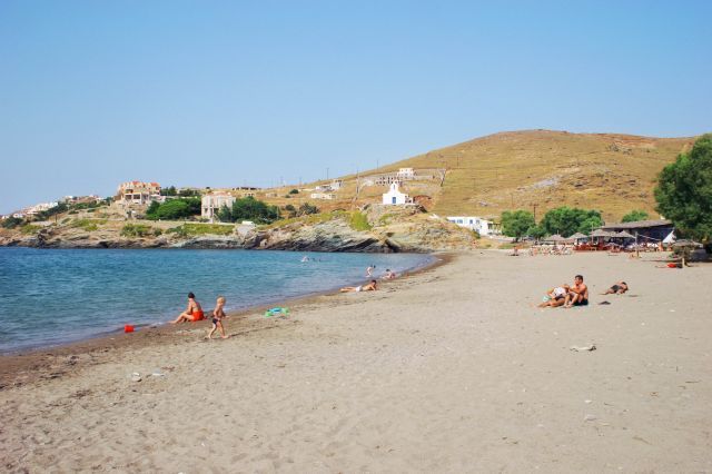
Kea
Visited in 2013
The Cyclades island closest to the mainland. Popular with weekending Athenians, but still quiet and largely unspoiled.
Ioulina
Kea is the nearest of the Cyclades to the Greek mainland. It is usually reached by ferry from Lavrio, a fairly unprepossessing port a 90 minute bus ride from Athens. However, there are also connections to other Cyclades islands. I sailed there on an early morning ferry from Syros via Kythnos.
Its location makes Kea a popular weekend destination for Athenians, some of whom have built modern villas on the island giving it a prosperous look. However, it is by no means overrun by visitors and its interior in particular is still perfect for quiet and relatively easy walking and hiking.
Korissa
The port of Korissia lies on the north west of the island and straggles along a wide bay in a fairly unmemorable manner. There are a number of places to stay and a cluster of okay but unspectacular tavernas and bars around the ferry quay. Car and bike hire is available and buses run to other parts of the island, albeit without any great regularity outside peak season.
Otzias
A 20 minute walk to the north, Vourkari is popular with yachties and is reckoned by some to have the best restaurants and nightlife on the island. Another four kilometres beyond, Otzias has one of the best beaches on Kea and something of a relaxed family vibe. I spent a very pleasant afternoon there alternating between lying under a shady tree and floating in the warm, shallow water.
Ioulina is the main village or Hora and is located about five kilometres inland from Korissia. Spreading out across two hillsides, it is a delightful place with neoclassical buildings, narrow lanes and an array of upmarket restaurants and bars. Most people park at the bottom of the village and walk to the centre as vehicular access is restricted for much of the day.
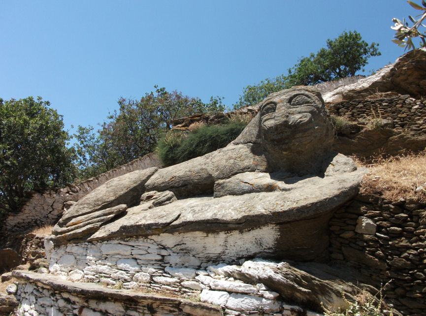
Lion of Kea
Just outside the village is the Lion of Kea, a carved stone sculpture of a rather stoned looking feline about 6 metres long that dates back to the 6th century BC. As is often the case in Greece, access to this probably priceless ancient work of art is a bit rough and you’re likely to share your viewing experience with a herd of munching goats crapping all over the ancient stone work.
Pisses
A paved road runs from Ioulina southwards to the undeveloped but rather windswept beach at the wonderfully named Pisses. Naturally I had to go there just to see what a place of that name looked like. Rather rough and ready and dominated by a large campsite was the answer. I didn’t stay long.
Kea is the most northerly of the Western Cyclades, which are sometimes called the Dry Cyclades. This is reflected in its somewhat rocky and barren landscape. However, Ioulina is a charming and vibrant Hora and Otzias is a pleasant seaside village. They are probably the best options for a place to stay from which to explore.
Kimolos
Visited in 2014
Milos’ smaller neighbour with whom shares unusual landscapes. Quiet and pretty but a bit unexceptional.Maybe an acquired taste.
Psathi & Chora
Recently I was somewhat surprised to find the travel section in a best-selling Sunday newspaper tip Kimolos as the next must-see, undiscovered Greek island. My experience of Kimolos is limited to a four hour stopover on the way from Sikinos to Milos, but I have to say that what I saw in that time has not got me champing at the bit to go back and see more.
Kimolos is Milos’ smaller, easterly neighbour. It does have direct ferry connections to Piraeus via a variety of different islands, but the most common means of access is the local ferry that goes back and forth between it and the port of Pollonia on the north east tip of Milos. Like Milos, Kimolos is a volcanic island where mineral mining is a major industry. Its name derives from the Greek word for chalk although, nowadays, Fuller’s Earth is its main mineral product and, no, I have no idea what Fuller’s Earth is used for.
Psathi
The island port of Psathi is small and nondescript at best. There are a few tavernas and a beach of large, rather uncomfortable pebbles. The only activity when I visited was two men on the beach shovelling up pebbles from one spot, putting them into a wheelbarrow and moving them to another spot about 10 metres away. I have no idea why, but then I didn’t ask.
Hora
The Hora is about a 15 minute walk up a fairly gentle hill and has a bit more to it. It is built around a well preserved kastro and has a traditional Greek village ambiance. However, early in the season in May much of it looked unopened and rather rundown with paint flaking on shutters and doors hanging off hinges. Nonetheless, this seemed to be where most of the visitor accommodation and the majority of tavernas are located.
The lackadaisical approach of Kimolos to tourism is perhaps best encapsulated by my walk back down to Psathi during which I encountered about a dozen elderly and portly French visitors sweating heavily as they dragged suitcases up the hill. I was interrogated about the availability of rooms to rent in the Hora because they had been unable to find any in Psathi, which is one of those island ports where ferry arrivals don’t appear to be met by the usual crowds of local ladies offering accommodation. Perhaps they are all on the Air B&B website nowadays.
Kimolos
A half hour walk on a paved road west from Psathi brought me to the small coastal village of Alyki where there appeared to be a few tavernas and rooms for rent. Its beach offered a good stretch of sand but limited shade. The village was not unduly enhanced by its proximity to a large saltpan.
I may be unfair to Kimolos and may have missed its most attractive aspects, but it felt significantly less interesting and welcoming than its larger neighbour to the west. It’s true to say that I wasn’t particularly sorry to get on to the ferry to Milos.
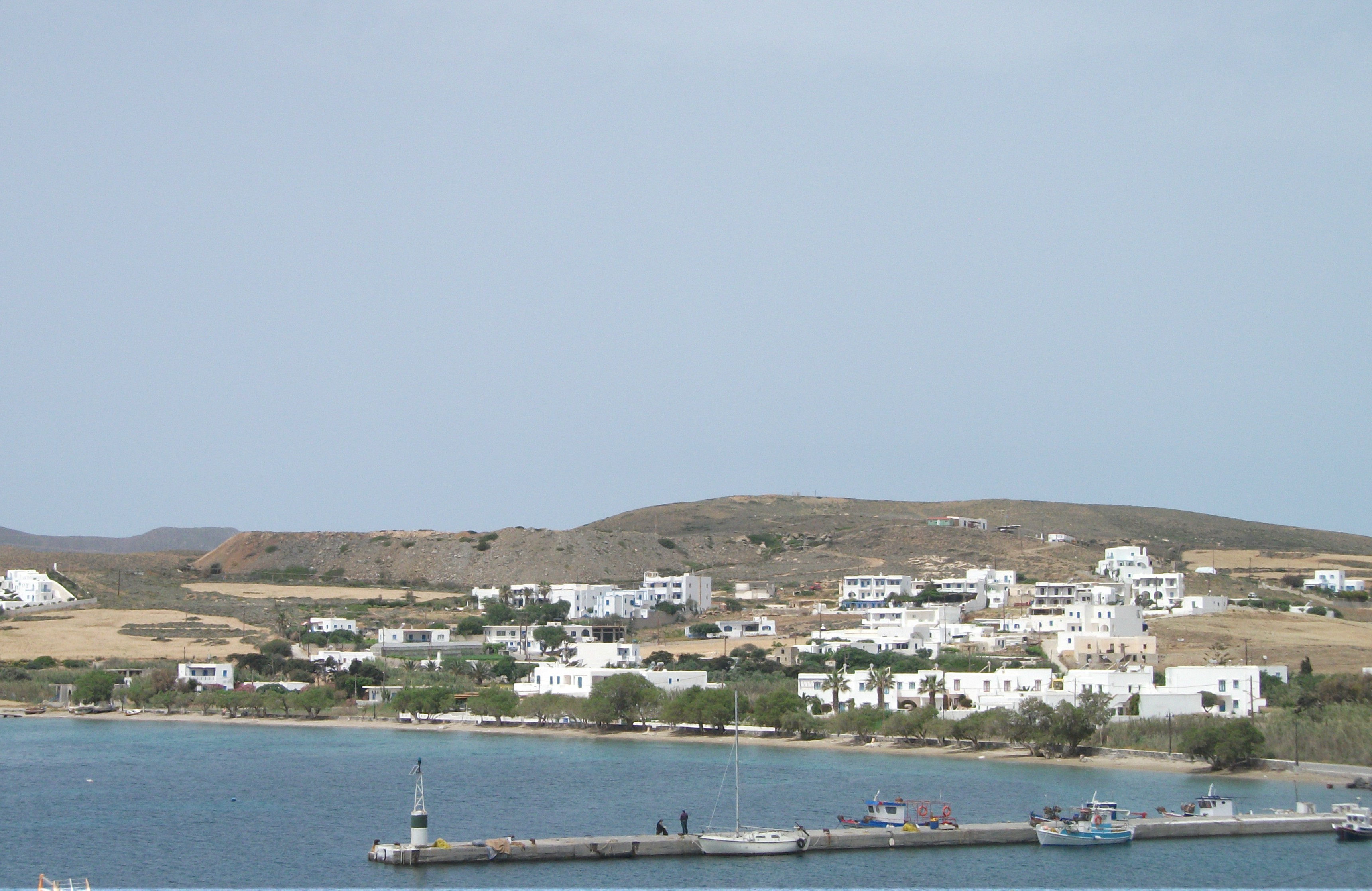
Koufonissi
First Visited in 2007. Most recently visited in 2017.
The busiest of the Lesser Cyclades with a bit of a buzz about it. The main draws are its spectacular beaches and lively main village.
Hora
On the Greek islands sometimes the simplest elements make for the most memorable experiences.
I first visited Koufonissi on a day trip excursion from Naxos and will always treasure the memory of sitting with my wife in a waterside taverna eating grilled octopus, drinking cold beer, looking across to the uninhabited island of Keros and a little fishing boat chugging along on the bright turquoise water, while chatting to the local doctor about island life. I’ve eaten octopus and drunk beer on many an island but somehow, that day, they tasted spectacular on Koufonissi.
I’ve since been back to stay on what is the most populated and most developed of the Lesser Cyclades, although we are still talking about an island with less than 400 permanent residents and a relatively short visitor season.
There are actually two Koufonissi islands. The larger Kato Koufonissi has no more than one seasonal taverna and a couple of holiday villas for hard core escapists. On petite Anno Koufonissi life largely revolves around one whitewashed village and a series of spectacular beaches.
Hora
The pretty, waterfront Hora of Anno Koufonissi spreads over two distinct districts which are separated by a wide sandy beach that also acts as the unofficial road between them. The district to the east is largely modern with a good range of high quality accommodation. The more traditional western district also has a varied choice of accommodation, but more tavernas, little shops and authentic Greek island atmosphere, despite the recent opening of a new yachting marina.
I’ve always stayed in the western district, which is where you will find most of the night time action. The tavernas can be surprisingly lively, sometimes with live music, and I have a favourite bar whose tables spill out across one of the main streets. The best way to end an evening is to sit with a coffee and a Metaxa brandy watching people pass by and listening to locals arguing about backgammon and life in general. Sometimes you find yourself drawn into conversations and discussions that result in more brandies and a slightly unsteady walk back to wherever you’re staying.
Finikas
Ano Koufonissi is a relatively flat little island where a string of about half a dozen wide, sandy beaches stretch eastwards from the Hora. Finikas, the nearest, is a 10 minute walk. Getting to Pori, the most remote and the largest, still requires less than an hour of easy coastal walking, or can also be reached along a shorter but rougher and less obvious inland track. As you go further east, the beaches become quieter and more favoured by nudists.
Hora
Koufonissi is simply charming. An escapist’s bolthole with good food, comfortable accommodation and a bit of interesting night life. It’s about 3 hours sail from Naxos on the local Express Skopelitis ferry but also has regular larger ferries. It’s a perfect introduction to the Lesser Cyclades.
Kythnos
Visited in 2013
Stark and barren. Good walking around the attractive inland villages, but the coastal villages are rather nondescript.
Episkopi Beach
I’d seen poor little Kythnos in the Western or Dry Cyclades described in one well known guide book as “barren, dull and lacking decent beaches”. Perversely, this piqued my curiosity and I went there hoping to uncover some outstanding feature that everyone else had missed. I didn’t.
First impressions as we sailed into the port of Merihas were of the brown and bare appearance of the landscape, even in May before the sun had had much chance to parch it.
Merihas
Sadly, Merihas did deliver on the “dull” description. My experience there was maybe not helped by staying in poor quality accommodation, being served the worst gin and tonic I have ever encountered – three parts rough, throat stripping alcohol to one part very flat tonic – and facing a meal of fish with garlic sauce in which the latter was a mountain of almost raw crushed garlic that took up more than half the plate. In summary, Merihas is not a place of much sophistication.
Dryopidha
Thankfully, things get better as you move inland. I enjoyed a very pleasant, if windy, day walking on a circular route that took in the two main inland villages of Dryopidha and Hora. The former is a beautifully located, red roofed village spanning a ravine. From there you can follow a paved road or a cobbled footpath round to the Hora. It is larger and not as pretty, but has a wider selection of tavernas and bars that spill out on to its narrow lanes. The route between the two follows a high ridge with spectacular sea views and passes close by the chapel of Agios Spyridon as well as various ruined windmills. It takes about an hour and half to walk from one village to the other.
Hora Eatery
From Hora, there is a paved road north east to the coastal spa village of Loutra, which locals regard as the island’s main resort. However, an English mother and daughter who I kept bumping into advised that it wasn’t worth the effort of walking there. I respected their judgement and didn’t go, preferring instead to circle back to Merihas via a swim and rest on the hard sand beach at Episkopi.
Kolona Beach
Episkopi was pleasant enough for me to spend the next day exploring it and the neighbouring beaches of Apokroussi and Kolona more fully. Kolona is the most attractive with a sand spit that reaches out to a small offshore island. Episkopi has the most shade but I found it a bit plagued by hyper active insects who seemed to find my burning skin irresistible.
I originally planned to spend three or four nights on Kythnos. After two nights I was keen to get away and jumped on an unexpected ferry to Serifos in search of something more interesting. If you do go to Kythnos, my advice would be to get out of Merihas as quickly as possible and head for Dryopidha or Hora to make them your base. They may be some distance from a beach but they have more life and more visual appeal than other parts of the island.
Milos
Visited in 2014
An interesting mix of tourism and everyday local life with a varied history and distinctive landscapes. Original home of the famous Venus de Milo.
Mandraki
Milos, the most southerly of the Western Cyclades, is an unusual but immensely enjoyable island with good ferry and hydrofoil connections as well as an airport with daily flights to and from Athens.
It is almost split in two by a deep bay that acts as a huge natural harbour. The lively capital, Adamas, sits on the north shore of this bay looking south.
Adamas
Milos is a working island despite its numerous excellent beaches and its popularity with the yachting set. Quarrying of minerals has scarred the countryside in places but has also given the island prosperity and some unexpected landscapes. The story of local mining is told in an interesting museum in Adamas, which incorporates some very moving oral testimonies of old miners.
Adamas
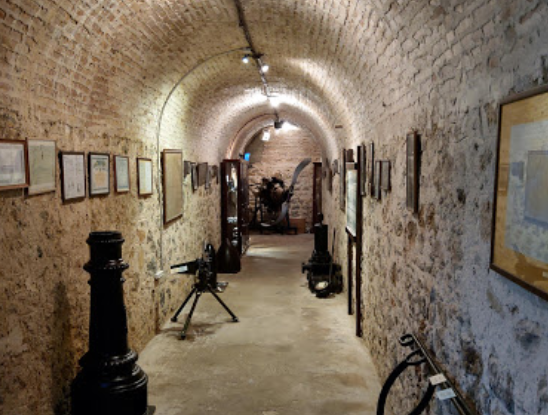
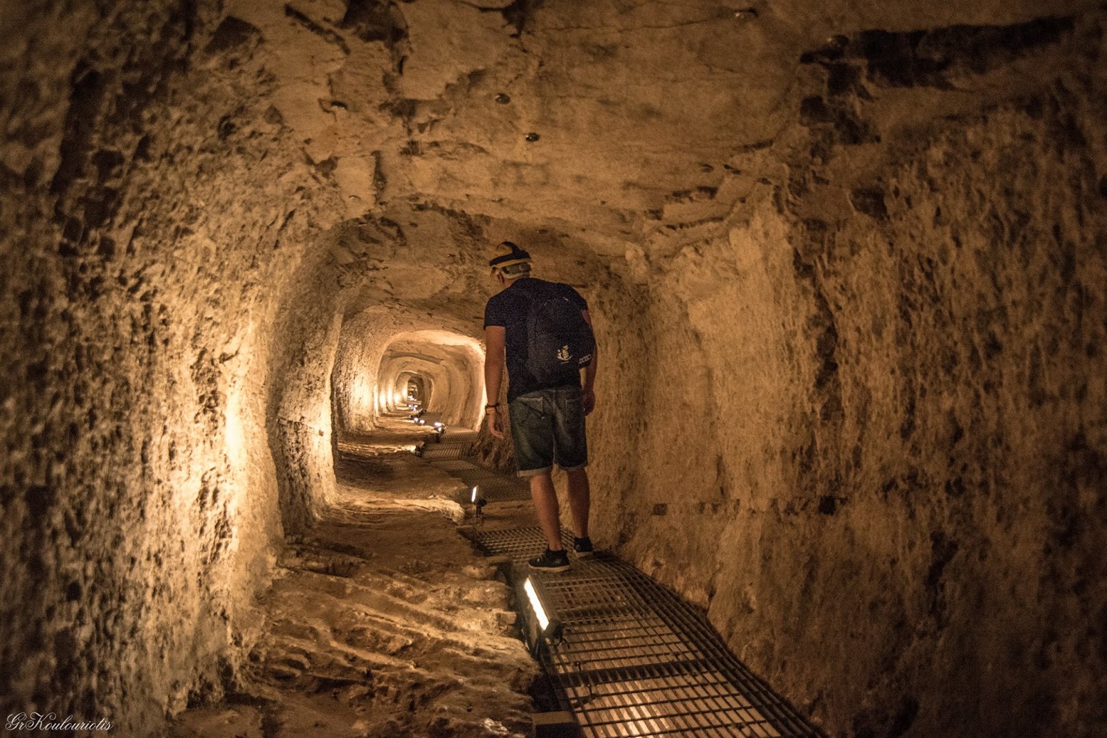
Its huge natural harbour made Milos an island of strategic importance in World War 2 and the Germans carved an extensive underground command centre out of the soft local rock on which Adamas is built. When I visited, this had been opened up to act as an exhibition space for local artists. However, the underground walls still displayed examples of Nazi propaganda art – Bolshevik bears slaughtering innocent Aryan children and the like.
Adamas, Art Exhibition in World War II Tunnels
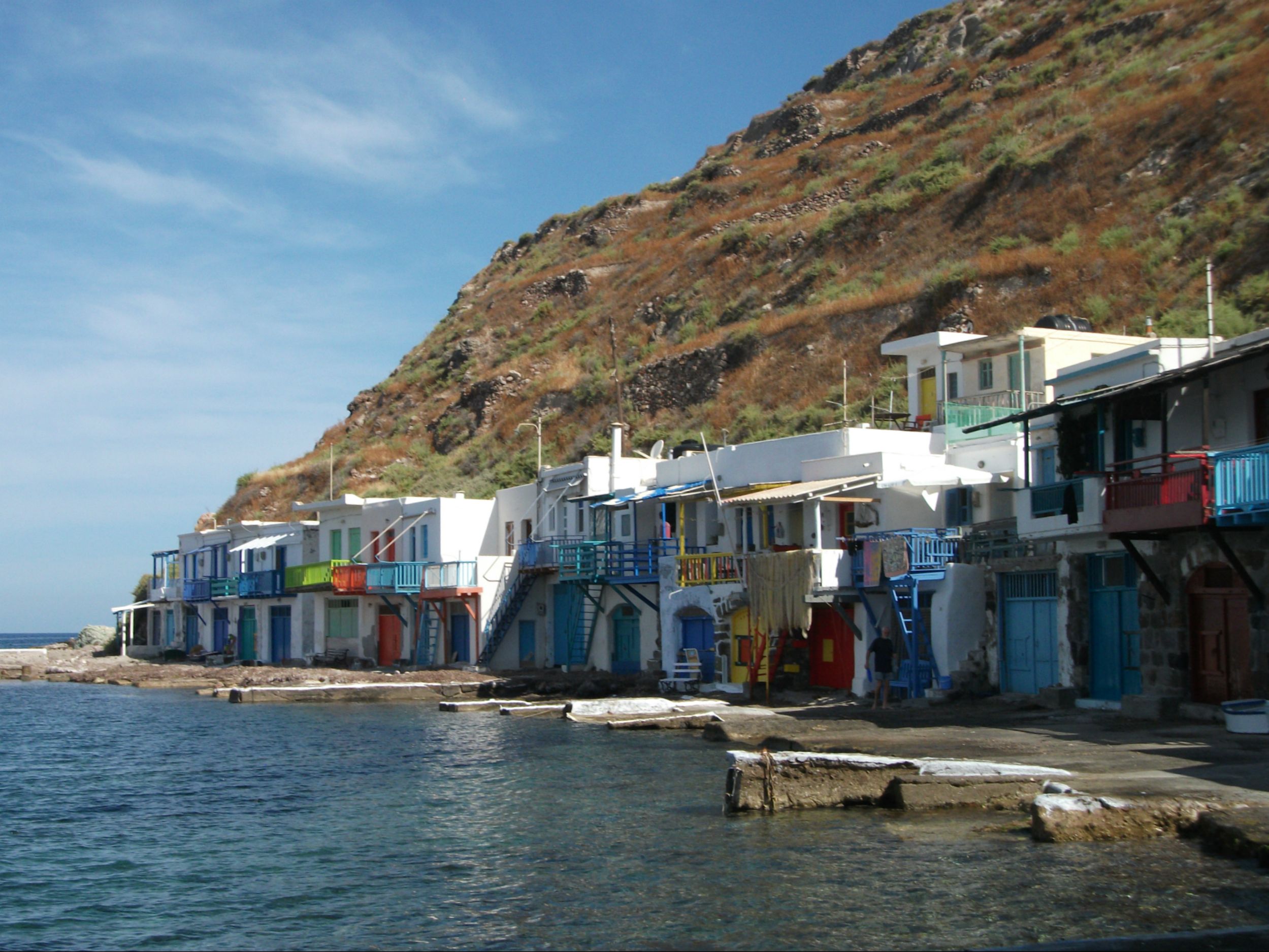
A few kilometres inland and north of Adamas, Plaka and Trypiti are surprisingly large and busy villages with places to stay (including renovated windmills), highly regarded tavernas, some early Christian catacombs and an ancient amphitheatre close to where the famous Venus de Milo was found. A steep walk down to the coast brings you to the fishing hamlet of Klima, the most photogenic place on the island with its single row of brightly painted boathouses. A road north from Plaka leads to the less well-known but equally attractive and distinctive fishing village of Mandraki, where boat houses are carved out of the local rock.
Klima
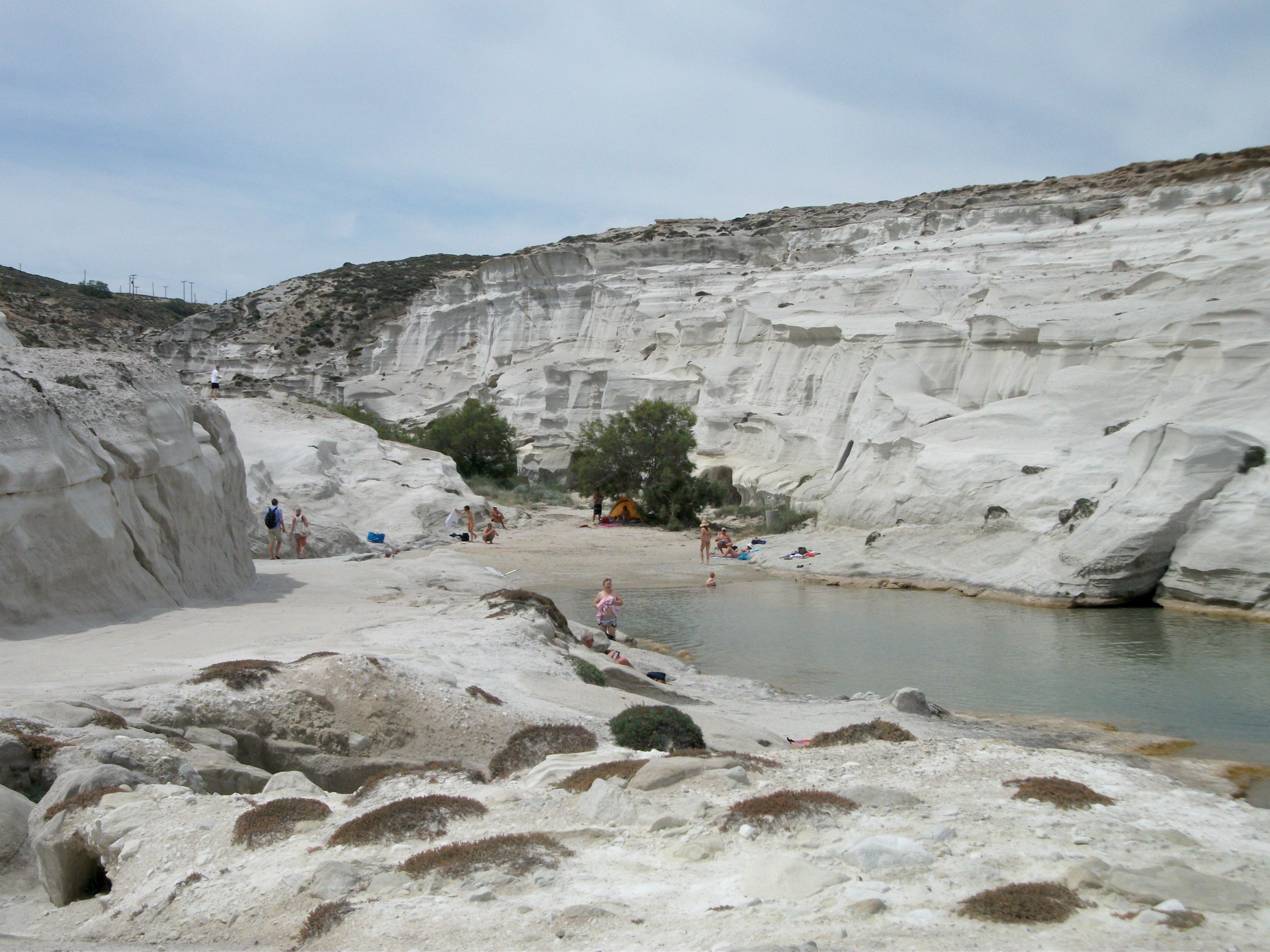
Heading east along the north coast of the island, the popular cove of Sarakiniko has a small sandy beach surrounded by parched white rocks. It’s strange, almost lunar landscape makes it one of the must-sees on Milos, but larger, less crowded beaches can be found nearby. The main road ends 12 kilometres from Adamas at Pollonia, the main ferry port to neighbouring Kimolos. The village has a long, curved sandy beach and is popular with windsurfers, but has maybe lost a bit of its original character as it has expanded.
Sarakiniko
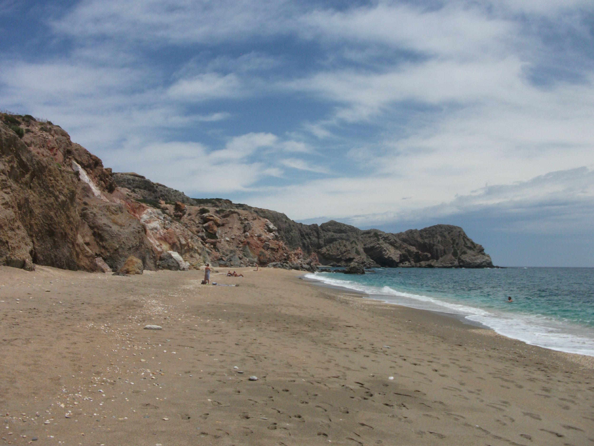
The south coast of Milos is by far the quietest. Paleohori has a huge but somewhat exposed, sandy beach and a few tavernas with rooms to rent, while Zefyria, once the island capital, is now largely deserted. The further west you go on the south coast, the quieter it becomes. There are a few good beaches but the countryside is pastoral rather than spectacular and there are limited visitor facilities.
Paleohori
Its mining heritage makes Milos pretty unique in terms of landscape and history. It is a fascinating island, but one that will also appeal to visitors simply wanting to chill out on a beach during the day and enjoy traditional Greek night life in the evening.
Mykonos
Visited in 2010
One of the busiest and most crowded Greek islands. Struggling to cope with visitor numbers. Scenically undistinguished but with large, popular beaches and endless nightlife.
Mykonos Town
Let’s not beat about the bush. Mykonos is as far from quiet and unspoiled as you can get. In fact, it is crowded to the point of being unpleasant at peak times of year.
Having originally established its tourism credentials in the 1960s as a chic destination for the bohemian gay market, it now caters for all types of visitors many of whom are attracted by regular direct international flights to the island’s airport and a seemingly endless succession of ferry and hydrofoil services from both Pireaus and Rafina.
Mykonos Town
The end result is that Mykonos now attracts over a million overnight visitors a year, to whom can be added a further half million or so cruise ship passengers who dock in for the day. So many people to fit on to a comparatively small island that, in truth, has no outstanding natural scenery or historical remains.
On a more positive note, the beaches of Mykonos are outstanding, if generally over developed, and the main town, which shares its name with the island, is among the prettiest in Greece. Just don’t expect to have the beaches or the twisting lanes and alleyways of the town to yourself, especially if two or three cruise ships are in port at the same time.
Mykonos Beach Life
Mykonos is pricey compared to most other Greek islands, but the quality of accommodation, eating places and nightlife is generally of the highest standard. Mykonos Town is the place to stay, unless you’re particularly keen on purpose built beachside resort hotels. Most visitors head to the beaches by bus or excursion boat during the day and flood back into the town for evenings that can go on until the wee hours of the morning and beyond.
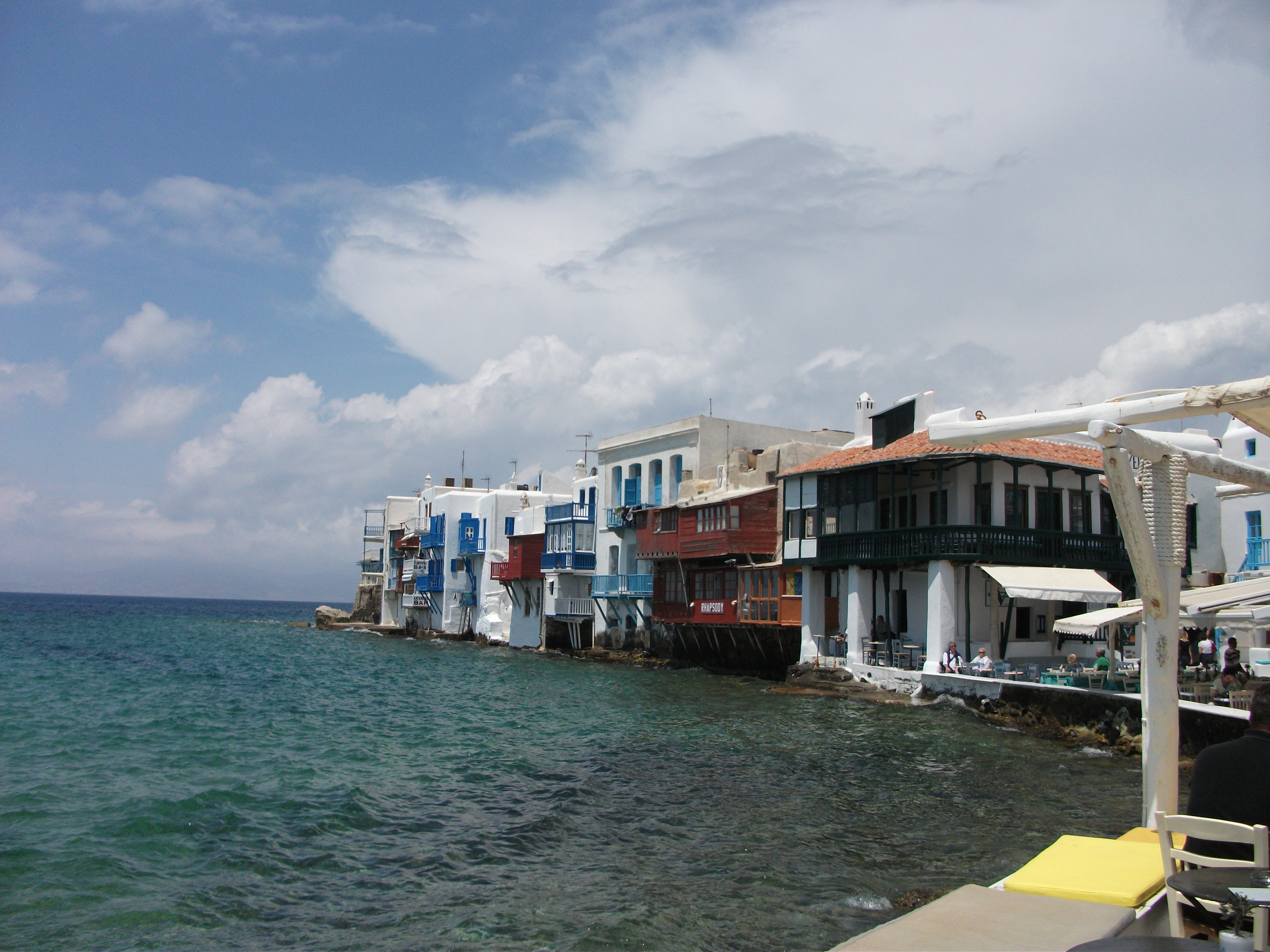
Mykonos Town, Little Venice
Mykonos Town has more shops, bars, restaurants and nightclubs than even the most dedicated party animal could visit over an extended summer period. The Little Venice area is particularly popular and photogenic with its whitewashed houses right on the water’s edge. A famous line of windmills offers more photo opportunities if you can tear yourself away from the nightclubs full of the beautiful people.
If arriving on Mykonos by ferry, it is worth noting that the modern main port is some four or five kilometres north of the town. Finding a taxi or getting on a bus can be a bit of a scrum, but it will maybe give you some much needed practice of using your elbows to get to where you want to go. Sharp elbows and a steely determination are real assets in the crowded streets and beaches.
Naxos
First Visited in 1989. Most recently visited in 2017.
The largest of the Cyclades islands. Lots of tourism development on its coastal areas but has largely unspoilt and attractive inland villages worth exploring.
Naxos Town & Kastro
Mountainous but fertile, Naxos is the largest of the Cyclades islands. Tourism vies with agriculture as the main industry and, although there are some scars of overdevelopment, in general the island is more than large enough to accommodate the visitor numbers it attracts. It still maintains something of a traditional Greek ambiance, especially in its attractive inland villages.
Naxos Town, the largest settlement and main ferry port, tumbles down from an atmospheric Kastro area to a bustling waterfront crammed with bars, tavernas and one of the best soulaki takeaway outlets on the Greek islands. The town now extends out to the long sandy bay of Agios Georgios where much of the visitor accommodation is located in modern, undistinguished hotels and studios. Windsurfing and other watersports are available on the beach along with more tavernas and bars.
Kastro
To the south of the main town, excellent beaches have resulted in the development of a string of largely characterless, purpose built resorts comprising mostly of holiday villas and apartments bought by Germans and Scandinavians. These are fine as sunbathing factories but little else.
Apiranthos
Heading east out of Naxos Town brings you to a particularly attractive farming area called the Tragea, which is dotted with pretty villages, whitewashed churches and monasteries, and medieval Venetian towers. Apiranthos is the most visited and arguably the prettiest of the villages with marble flagstoned lanes, a charming main square, some well-preserved mansions and good walking.
The coastal village of Moutsouna, some 12 kilometres to the east, was once the main port for local emery mines, an industry that collapsed in the 1980s. When I first visited Naxos, Moutsouna had something of a semi-derelict, post-industrial feel. Now it has smartened itself up with new villas and tavernas and a newly paved road runs south from it to large, undeveloped sandy beaches that you might be lucky enough to have to yourself.
Moutsouna
From Apiranthos the main road heads up to the northern tip of the island and the pretty little resort of Apollon, a popular stopping point for coach trips. It is noted for its fish tavernas and large kouros, or recumbent stone statue, dating back to 600 BC. A spectacular coastal road heads south back to Naxos Town, passing the charming pebble beach and village of Abrami as well as a number of notable historic buildings.
Apollon
I’ve been to Naxos on numerous occasions and have always enjoyed it. It is well served by ferry services and has daily internal flights to and from Athens. It’s large enough to find your own quiet corner and has some of the most attractive inland scenery of any of the Cyclades. It’s a good taster of Greek island life for first time or fairly new travellers to Greece, especially if combined with its near neighbour, Paros, of which more now follows.
Paros
First Visited in 1985. Most recently visited in 2017.
Probably the best connected of the Cyclades islands, making it ideal as a base for island hopping. Busy in parts, but still possible to find quiet corners.
Piso Livadi
Paros is Naxos’ slightly smaller and flatter neighbour, lying about an hour’s ferry ride to the west. It is also an important ferry junction with services heading out on all directions, making it an ideal first stop on any island hopping adventure in the Cyclades.
Parikia
Parikia, the largest town and main port, lies on a broad bay on the west coast. It is a friendly, bustling town of whitewashed houses and narrow lanes and alleyways filled with craft shops, minimarkets and tavernas. The area around the traditional kastro is a popular spot for contemplating the sunsets armed with a cocktail or two. There are beaches in the town centre but they are nothing special, although one does boast a popular campsite.
Naoussa
A paved road runs right round the island and is served by regular buses that pass through most places of interest. Naoussa on the north coast is Paros’ second main resort and is favoured by those looking for something more upmarket and picturesque than Parikia. It’s a bit more expensive than its larger and louder neighbour and the best beaches are away from the town centre, but the pretty harbour is a jumble of waterfront tavernas selling fresh seafood caught that day by local fishermen.
From Naoussa the main road heads south down the east coast of the island to the charming little village of Piso Livadi which is blessed with a beautiful sandy beach, a laid back harbour and a good choice of tavernas and places to stay. The coastline further south is a series of large, generally quiet, sandy beaches. Dryos and Khryssi Akti (also called Golden Beach) are probably the best known, with a low level of development but a choice of accommodation and eating places.
Khryssi Akti (Golden Beach)
Heading round the southern tip of the island brings you to Alyki, a sedate little beachside village that appears to have expanded a lot in recent years but still retains a pleasant, laidback ambiance. The island airport is close by but it’s once a day flights to and from Athens don’t cause much disturbance. From here it is about a dozen kilometres back to Parikia via the small village of Pounda that acts as the local ferry port to the neighbouring island of Antiparos.
Lefkes
Another paved road cuts inland across the island from Parikia to Piso Livadi passing through Lefkes, a largely undiscovered gem that is maybe the most attractive village on Paros. The locals actively embrace sustainable tourism and organic eating in the many tavernas that are scattered around its broad, timeless streets and squares that open out to spectacular views across the island.
Lefkes
Like Naxos, Paros is a perfect introduction to smaller Greek islands away from the main package tour destinations like Corfu, Kos or Rhodes. Ferries from Piraeus take about four hours, usually leaving early morning and arriving just before noon. The island has a mix of different experiences from the biz of Parikia to the sleepiness of Alyki and Piso Livadi. It’s one of the easiest islands to get around and it is still possible to share a long, sandy beach with only two or three other people.
Santorini
First Visited in 1989. Most recently visited in 2016.
Arguably the most spectacular and most recognisable of all Greek islands. Can be unpleasantly crowded but still somewhere you have to visit at some stage.
Ammoudi & Ia
Santorini is arguably the most scenically spectacular island in Greece but, like Mykonos, in recent years it has been somewhat overrun by visitors. Thought by some to be the origin of the legend of the lost city of Atlantis, it was originally a much larger island, parts of which sank into the sea in a volcanic eruption 3,000 years ago. This eruption left a huge water filled caldera and a west coast with sheer cliffs reaching up to 1,000 feet and topped by breath-taking whitewashed villages.
I first visited Santorini in the mid-80s and stayed in a clifftop cave house in the northern village of Ia, which was an attractive but rather sleepy place with a limited range of tavernas and shops. My arrival involved jumping mid-ocean from the car deck of a large ferry on to a local fishing boat and then clambering on to a donkey for a long slow ride up the cliff face to the village.
My most recent visit in 2016 involved me travelling on one of the numerous daily high speed hydrofoils from Crete carrying hundreds of day trippers who were met by two dozen (I counted them) coaches at the main port of Ormos Athinios. On the same day, three mega cruise liners disgorged thousands of day visitors via tenders to the old port immediately below the main village of Thira, from where cable cars took them up the cliff face from sea level to the village. I was told some had to queue for almost two hours to get on a cable car.
Fira
The owner of the hotel where I stayed informed me that the island now hosts over 250 weddings a year, mostly of couples from the Far East. Santorini can’t accommodate any more weddings but, undeterred, couples now come from the likes of China and Korea to have their wedding photos taken on the island before they return home for the actual ceremony itself.
Ia
Far from being a sleepy hollow, Ia is now full and overflowing with visitors who cram its narrow lanes that are packed with souvenir shops and boutiques. The public service bus on which I rode from Thira to Ia is probably the most overcrowded vehicle on which I have ever travelled and was a genuine safety risk. I took a taxi back to avoid any further threat to life and limb.
Santorini Sunset
Once the day trippers disappear, Santorini calms down a little but is still very busy. Crowds gather on the cliff tops in Thira, Ia and villages in between to watch the awe inspiring sunsets, while bars and tavernas do a roaring trade and night clubs pound out music well into the morning.
Away from the caldera, the east coast villages of Kamari and Perissa are forgettable package holiday resorts with British bars showing re-runs of Only Fools and Horses and beaches of gritty, black volcanic sand that can burn the soles of your feet during a rush into the cooling sea.
However, despite all its drawbacks, Santorini is still somewhere you must see at least once, for the scenery and the sunsets if nothing else. It’s far from unspoiled but it is still extremely beautiful.
Schinoussa
Visited in 2017.
Possibly the least interesting of the four Lesser Cyclades islands. Quiet with limited visitor facilities but a good choice of beaches.Don’t expect too much excitement.
Schinoussa
Schinoussa is the last of the four Lesser Cyclades that I visited and it is probably the least interesting. However, it is not without its charms and I’m sure has its devotees.
Like the other Lesser Cyclades, it is primarily served by the Express Skopelitis ferry boat as it wends its way between Naxos and Amorgos. It’s only 10 – 15 minutes sail east of its nearest neighbour, Iraklia, and just under an hour west from Koufonissi. It is also served by occasional large ferries heading to and from Piraeus, although they tend to come and go at odd times of day and night.
Mersini
The island’s port, Mersini, is tiny with no more than a couple of tavernas with rooms and maybe half a dozen other buildings at most. The majority of visitors head uphill along the road or paved footpath to the Hora, Panagia, which is about 15 minutes walk from the port. Here there is a wider selection of rooms to rent and a couple of hotels, as well as four or five tavernas and a few shops.
Panagia
The scenery on Schinoussa is gentle and agricultural rather than wild and bare. The countryside is dotted with small churches, windmills and dovecots. The paved road extends to the tiny, almost comatose, hamlet of Messaria, which is surrounded by olive groves and boasts panoramic views across the water towards Iraklia.
Despite its small size, Schinoussa claims to have over a dozen beaches, most of which are accessible along well signed tracks and dirt roads. Tsigouri is the closest to Panagia and has an upmarket villa complex with a popular taverna. I visited most, but not all, of the beaches and my favourite was Lioliou, a long crescent of rough sand and a few pebbles overlooked by only a scattering of private villas. I had it all to myself for a long afternoon in May. Indeed, almost every beach I visited on the island was deserted, but things may be different in peak season.
Lioliou Beach
What nightlife there is on offer is centred on the island’s tavernas. In May, their main entertainment was televised football matches – Greek league rather than international showdowns. Menus were largely standard Greek fayre with little that was either outstanding or disgusting.
I’m maybe being unfair to Schinoussa in comparing it very directly to its three Lesser Cyclades neighbours, but it seemed to lack their more open and welcoming ambiance and sense of place. Cloudy weather maybe had something to do with that but, of all the Lesser Cyclades, it’s certainly the last I will rush back to.
Serifos
Visited in 2013
A picture postcard main village, a pleasant port village and some good beaches. In some ways a typical Greek island, but one that retains much traditional character.
Livadhi & Chora
Unbeknownst to me at the time, Serifos was the very first Greek island I ever saw properly.
On my first visit to Greece in 1979 I took a very slow boat from Piraeus to Crete that stopped at numerous islands along the way. I knew nothing about any of them including their names. I was not alone. All of the other student, hippy types on the ferry were in the same boat, as it were. As we approached the first island out from Piraeus, word went round that it was called Syphillos. Cue much hilarity. Some 35 years later I sailed into Serifos and immediately recognised it as my very first Greek island port of call.
My first proper visit to the island was a short two day stay, crammed in at the last minute when I got bored of Kythnos. I stayed in the port of Livadhi and, having limited time to explore, saw only one small corner of Serifos, partly because I was feeling lazy and the lure of the beaches was too strong.
Livadhi
Livadhi is a friendly little place on a wide bay that is popular with yachties. The beach is nothing spectacular, but there is a good choice of accommodation and plenty of tavernas and bars in which to pass the evenings. I got into an interesting conversation about God knows what with a group of friendly Finns (the seven deadly Finns perhaps?) in the very trendy Yacht Club bar, before heading for dinner in a seafront restaurant run by some celebrity chef who appears regularly in Greek TV. I don’t remember either his name or that of his restaurant but his stuffed squid and the friendly service were exceptional.
Hora
The Hora is a steep walk uphill from Livadhi and clambers up a mountain ridge like tiers of an iced wedding cake. Early in the morning when the smell of freshly baked bread fills the air it is quiet and atmospheric with classic Greek village lanes and alleyways opening out into tree-lined squares. There are spectacular views down to Livadhi and across nearby valleys, as well as plenty of interesting old buildings. The quickest way up is via a cobbled footpath from Livadhi that cuts across all the hairpin bends on the paved road. Take water with you – it’s quite a strenuous climb.
Livadhakia
While Livadhi’s own beach is not up to much, there is a choice of good alternatives within easy walking distance. Livadhakia, a ten minute walk to the south, is a long strand of soft sand backed by tamarisk trees that provide welcome shade. Its friendly taverna sells cooling drinks. Smaller Karavi is a further five minutes walk south and offers more sand but no shade or taverna. It appeared to be popular with nudists. Psili Ammos in the opposite northerly direction is a longer walk along a rough track, but is worth the effort for its fine white sand. It has a couple of tavernas. A further ten minute walk brings you to the larger but less appealing Agios Ioannis, another nudist favourite.
There is a lot more to Serifos that I didn’t see in my short stay, but what I did see was pleasing and attractive. I certainly plan to go back for a longer visit to explore more of it.
Sifnos
Visited in 2014
Upmarket with a busy main town, an interesting and unique medieval village, and excellent beaches. Increasingly popular with Greek visitorsattracted by its “foodie” reputation.
A Local Resident Turns His Back On Kamares
Sifnos is arguably the most popular visitor destination in the Western or Dry Cyclades. In recent years, its excellent ferry and hydrofoil links have made it a popular weekend destination with wealthy Athenians who support an impressive choice of good quality restaurants, bars and shops.
Kamares
Kamares, the island port, lies on the north west coast and boasts a spectacular sandy beach that curves round a wide bay. Many of the buildings are fairly recent additions to the tourist accommodation stock, but it still retains something of the traditional Greek island village ambiance. Absinthe, on the main road, must be one of the best restaurants in all of the Greek islands with an imaginative menu, friendly service and a drinks selection that includes about 20 different types of absinthe. It’s worth ordering a glass for the theatrical serving ceremony alone. More than two glasses and you may temporarily lose the power of speech and sight. However, that’s a small price to pay.
Apollonia
The main village, Apollonia, is a 20 minute ride uphill on one of the regular local buses and is where most of the visitor action is. It’s like a smaller, less frenetic and more charming version of the Hora in Ios with upmarket boutiques, high end restaurants and bars, and late night music clubs.
Kastro
Kastro, on the east coast below Apollonia, is a beautifully preserved medieval village that was once the island capital. Perched on top of rocky cliffs, parts of its boundary walls and many of its original houses and churches are still intact. It’s well worth an hour or two of proper exploration.
Kastro, Epta Martyres Church
On the south of the island are three beach resorts that are linked by paved roads to Apollonia but not to each other. Platys Yialos is the largest, best known and probably the least appealing. It’s much vaunted beach, which claims to be the longest in the Cyclades, is pretty narrow and backed by characterless rooms and tavernas. It has limited charm and something of a package holiday resort feel.
Faros
Faros to the east is smaller and quieter and offers a choice of decent beaches within a half hour’s walk, but Vathy to the west is best of all with soft sand on a wide bay and a good range of tavernas and accommodation. The centre of the village is traffic free and vehicles have to stop at the car parks on the edge of the main beach. Vathy has a fairly new luxury hotel that allegedly attracts various celebrities, but the beach is large enough to cope with increases in visitor numbers.
Vathy
For a real get away from it all experience, the isolated hamlet of Heronissos at the very north of the island has sand, a small harbour and a couple of tavernas. Nothing much appears to happen here and it is all the better for it.
Hersonissos
Sifnos has an attractive landscape, pretty villages, excellent beaches and good quality food and accommodation. What more can you ask for?
Sikinos
Visited in 2014
A largely forgotten and bypassed little gem of an island with a peaceful atmosphere, good beaches and a spectacular main village. Limited tourism facilities, but loads of character.
Alopronia
One guidebook describes Sikinos in the southern Cyclades as “a quiet and forgotten backwater”. This is more than a little unfair, although it does have a population of less than 300 residents; was the last island in the Cyclades where visitors were tendered ashore from ferries; and the last to have a regular bus service to move them around on the island. Situated between Ios and Folegandros, its quiet charm and relaxed atmosphere make it one of my favourite Greek islands.
Kastro & Hora
There are three tiny villages on Sikinos – Alopronia, the port; Kastro, the main village a few kilometres inland; and its near neighbour Hora, which is little more than its suburb.
Alopronia
Alopronia has a long beach of soft sand with shady trees and most of the limited visitor accommodation on the island, including the upmarket Porto Sikinos hotel. The restricted range of tavernas and bars is generally adequate to cope with visitor numbers and the main activity takes place when the village shop receives fresh supplies off a ferry and locals flock to it to grab whatever they can before their neighbours take it all.
An erratic and somewhat eccentric bus service runs up to Kastro, a jaw droppingly pretty village located on a ridge high above the sea with a footpath climbing up to a little monastery. Its narrow lanes have a number of characterful shops and cafes with old men sitting outside putting the world to rights. One café had shelves of large glass jars with a variety of exotic looking roots, herbs and plants. I’m not sure if they were for drinking, eating or smoking, or all three. Certainly the owner was happy to give me a smell of each and I wandered off feeling slightly stoned.
Kastro
From Kastro, a paved road runs for about five kilometres past abandoned cliff side terraces and a new local winery to the ruined 7th century church at Episkopi, which incorporates parts of an earlier temple. It appeared to be in the midst of an extensive but probably slow renovation when I visited, but the walk is worthwhile for the spectacular views across to neighbouring islands. A well signed footpath to Alopronia provides an alternative route back.
Episkopi
Also from Kastro another paved road runs through emptiness for six kilometres to the remote beach of Agios Yeorgios where there was a closed and derelict looking taverna and nothing else. A local map indicated a footpath from there back to Alopronia but I struggled to find its start although I could see it in the distance. Consequently I found myself scrambling over old cliff side terraces in a vain attempt to get back to the paved road before an impending downpour that left me soaked. The beach at Agios Nikolaos is closer to Alopronia, easier to find and better quality.
I loved Sikinos, despite my soaking. The ferry I intended to take out of the island was badly delayed, which gave me a perfect excuse to stay longer than planned. I’m glad I did.
Syros
First Visited in 2010. Most recently visited in 2013.
The administrative capital of the Cyclades. It’s main town, the largest in the island group, is a UNESCO World Heritage Site. Good ferry links to the rest of the Cyclades.
Ermoupolis
Syros can look a little off putting when you first arrive. Ferries come into the capital Ermoupolis, which is the largest town and the main administrative centre in the Cyclades. Shipyards give it a rather industrial look and the waterfront is a noisy mass of honking vehicles and people.
However, move away from the busy bars and tavernas of the waterfront and Ermoupolis takes on a much more relaxed atmosphere with elegant buildings and broad open squares that justify its status as a UNESCO World Heritage Site. It climbs up two hillsides, one topped by a Catholic church, the other by an Orthodox one.
Ermoupolis
I once spent a truly memorable evening in Ermoupolis in a back street taverna where, half way through my meal, a bouzouki player arrived followed by an army of locals who fired in requests, sang traditional songs and danced on the street. They insisted the lone tourist in their midst sampled the delicious local mezes they were enjoying while plying him with too much of the local wine. Never was a hangover more worth the pain of the next morning.
From Ermoupolis regular buses fan out to beach resorts that are mostly located on the same main circular road round the south of the island. Kimi is the exception, lying a little to the north only 15 – 20 minutes from Ermoupolis. It’s quiet, a bit scattered and has a couple of decent beaches.
Galissas
Galissas is arguably the main resort on the circular road. It is divided into two distinct areas: the newer beachside settlement and the older, more traditional agricultural village just inland. It has a good choice of tavernas and places to stay. The beach is a sizeable strand of hard sand and there is a pebble alternative much favoured by nudists within a short walk. There’s a bit of nightlife in a couple of music bars that seem to be frequented by locals more than visitors.
Finikas
Finikas to the south is quieter and has a narrow gritty beach with some shade. However, the beach is hard up against the main road and not always the place for a tranquil snooze in the afternoon sun. Posidonia, its near neighbour, is a bit more upmarket and close to the sandy beach of Agathopes. Heading east, Megas Yialos has colourful houses and a long, narrow beach. All three have a selection of places to stay and waterside tavernas.
Swinging back towards Ermoupolis, sleepy Arkadhi has a good family-friendly beach, while Vari is larger than its neighbours and appears to be popular with local teenagers. It is perhaps the most sheltered of the beaches on the main road, although the sands are overlooked by tavernas and rooms for rent meaning privacy is at a premium.
Vari
In general, the beaches of Syros are not as attractive as those of many other islands, but the villages are relaxed and friendly while Ermoupolis offers a pleasant option for anyone looking for a bit more biz and everyday local life.
Thirassia
Visited in 2016
Once part of Santorini, now it’s nearest neighbour. Shares the same unique scenery but not the crowds. A quiet escape from Santorini’s noise and bustle.
Korfos
Thirassia is Santorini’s nearest neighbour and was once part of the same island before a cataclysmic volcanic eruption separated the two. Now it shares the same topography of sheer cliff faces overlooking a flooded caldera.
Most visitors to Thirassia come on day trip boat excursions from Santorini that combine a lunchtime stop on the island with time in the mud springs of the nearby volcanic Kameni islets. However, it is possible to stay overnight and there are four or five passenger ferries a day from Ia in the north of Santorini, as well as more occasional large car ferries heading to and from Piraeus.
Riva
Ferries call in at Riva, a rather shabby, small port on the north of the island with a mediocre beach covered in bleached seaweed. It is best passed through as quickly as possible. A free community bus runs to the main village of Manolas. Alternatively, a pleasant walk along the main paved road takes you there in about 45 minutes.
Excursion boats dock for a couple of hours at Korfos, a characterless strip of tavernas and shops at the bottom of the cliff below Manolas to which it is linked by a steep footpath that snakes up the cliff face for several hundred feet. I tackled it with my usual hot headed enthusiasm in the full glare of the afternoon sun. By the time I got to the top I was all too aware of my advancing years and my limitless propensity to leak unpleasant quantities of sweat.
Manolas
Most day trippers don’t bother trying to make the climb up to Manolas, which is a quiet, slightly run down little village that offers spectacular views across the caldera to Santorini. However, it is not completely without visitors. I was enjoying lunch in a cliff top taverna that I had to myself until a tour party of about 50 people from Thailand descended upon it, most of them carrying their own oriental food in plastic Tupperware containers. Once they learned I had been to their country I was asked to pose for numerous photographs with them. I may now be a minor celebrity in the Far East.
Thirassia is geographically close to Santorini, but a million miles away from it in terms of atmosphere. In some ways it is the prettier island. It is certainly quieter and more relaxed, if a little rough round the edges. Well worth a visit if you want to escape the crowds on its neighbour, but if you want to see more of it use the local ferry from Ia rather than an excursion boat.
Tinos
Visited in 2010
An important site of pilgrimage for Greek Orthodox Christians. Lovely main town and excellent walking around the quiet and peaceful countryside.
Tinos Town,Panagia Evangelistra
Tinos has long been a place of pilgrimage for Greek visitors attracted by the church of Panagia Evangelistra where a nun found a miraculous icon with alleged healing powers back in 1822.
Today, pilgrims continue to climb the hill from the waterfront to the church on their hands and knees. However, local authorities have covered part of the route with a carpet to soften the journey, which is lined by stores selling tacky religious souvenirs as well as knee and hand pads.
Tinos Town Pelican Crossing
The church is in Tinos’ main town, which shares its name with the island. It’s a friendly, workaday place with some good quality accommodation and restaurants. When I first visited, the waterfront was enlivened by a chilled out pelican who wandered freely through the traffic of the town and could sometimes be seen hitching a ride on a local scooter. I don’t imagine he’s still there, but I have no idea how long pelicans may live for.
Tinos Village & Countryside
The countryside around Tinos Town is particularly attractive and criss-crossed by a well signed network of footpaths that provide enjoyable days of walking between picturesque local villages that skirt around the craggy Exoburgo mountain that dominates the south of the island. Tinos is renowned for its decorative dovecots that are liberally scattered across the landscape.
Porto
From Tinos Town, a paved road runs east to the upmarket beach resort of Porto passing other beaches along the way. Porto has a magnificent beach but felt a bit soulless and purpose built to me. The kind of place where visitors rarely venture outside their resort hotels or apartment complexes and prefer to spend their days by a swimming pool where waiters serve an endless selection of cooling drinks on an all-inclusive basis. However, I may be doing it a disservice.
Panormos
Another road heads north west out of town to the north of the island passing through the panoramic cliff top village of Kardhiani on its way to the marble quarrying centre of Pyrgos and the pretty seaside village of Panormos from where the marble was once exported. Now it has some pleasant tavernas and rooms to rent and is within walking distance of the beautiful beach of Rohari.
Tinos Produce
Tinos is well served with daily ferries and hydrofoils from Rafina that link it with Andros, Mykonos and Syros. It is apparently particularly busy around two major religious festivals on 25 March and 15 August when the holy icon is paraded through the main town. All guide books advise booking ferries and accommodation well in advance of these dates. At other times of year it is much quieter and offers some of the best easy walking on the Greek islands.
I really enjoyed Tinos. If you are on a tight schedule and can only visit one of the northern Cyclades, Tinos is the one to head for.
The Dodecanese islands lie to the east of the Greek mainland, close to the coast of Turkey. Prior to the First World War they remained part of the Ottoman Empire. When it disintegrated, they were administered by the Italians on behalf of the League of Nations as the powers that be weren’t comfortable joining them to the relatively young, modern Greek state which they viewed as unstable and sympathetic to Germany.
When the fascist Mussolini came to power in Italy, he began a programme of public building throughout the Dodecanese and started militarising some of the islands as a step towards creating a glorious Italian Empire. His plans were thwarted by World War 2 when the Dodecanese suffered heavy fighting due to their strategic position. After the war, the islands were finally re-joined to their mother country in 1947.
Although the name Dodecanese means the 12 islands, there are almost 20 permanently inhabited islands in the group, ranging from the busy main island of Rhodes to tiny dots like Pserimos and Marathi that might have about a dozen year-round residents. The group covers a vast area stretching from Agathonissi in the north to Kasos in the south and from Astypalea in the west to Kastellorizon in the east.
International flights from other parts of Europe come into Rhodes, Kos and, to a lesser extent, Karpathos. There are also airports handling internal Greek flights on 5 other islands. Most of the islands have regular ferry services to and from Piraeus, although journey times to some can be considerable. The majority are linked during the summer months by the hydrofoils of the Dodecanese Seaways company. Those in the north of the group are also served year round by the redoubtable Nissos Kalymnos ferry, which operates out of the island of that name. Smaller islands are linked to larger neighbours by a host of local ferries that also act supply boats.
In the mid 2010s, their proximity to Turkey has brought waves of displaced Middle Eastern and African migrants to various islands. Tiny Agathonissi woke up one morning to find that local residents were outnumbered three to one by bewildered migrants dumped there during one night of activity by people smugglers. The flow of migrants has now largely stopped but there are still pockets of displaced people living rough or in cramped conditions on a few of the islands. In general, they do not harass tourists and are simply keen to move on or find work locally to support their families.
Tourism is a significant industry on most of the Dodecanese islands, a few of which have highly developed package holiday trade and are amongst the busiest visitor destinations in Greece. However, on all islands it is still possible to find quiet, unspoiled villages where the pace of life hasn’t changed too much over the centuries.
Agathonissi
First Visited in 2013. Most recently visited in 2023.
The most northerly of the Dodecanese islands. Small but perfectly formed with limited tourism infrastructure. Quiet, peaceful and friendly. An island for escapists.
Agathonissi – The Three Villages
In some ways Agathonissi inspired my quest to discover Greek islands I had not previously visited. I was sailing between Patmos and Samos on the Nissos Kalymnos when it called in at an island I didn’t know existed. I thought I knew most Greek islands but this one had somehow escaped my attention. A study of the nautical chart on display on the ferry told me it was called Agathonissi. I had visited Samos about 8 or 9 times without seeing it mentioned or promoted anywhere on its larger neighbour. I was intrigued and wondered how many more islands I knew nothing about. The idea of my island bagging quest was born and, when I started it in 2013, Agathonissi was the first island I visited that was new to me.
Probably best described as sleepy, Agathonissi is the most northerly of the Dodecanese islands with just under 150 residents spread across three tiny settlements.
Ayios Yeorgios
The port of Ayios Yeoryios has three or four locals letting out rooms, some new upmarket visitor accommodation, a few tavernas and cafes, and a mini-market, which combine to make it the busiest place on the island. It also has a sizeable pebble and sand beach with shady trees. There is a slightly grittier, but more secluded beach within a 10 minute walk around the headland at Spilia. This is signed as “Cave Beach”, presumably on account of the fairly shallow cave at one end of it. It also has shade and some benches.
Megalo Horio
The main village of Megalo Horio is a 15 – 20 minute walk uphill and has a town hall, school, post office and ATM as well as a mini market and a couple of tavernas that seem to open as and when they feel like it. There is also one of those ubiquitous mini football pitches with artificial grass that were built all over Greece after the national team surprised everyone, including themselves, by winning the European Championships in 2008 (I think). There is a further settlement of about half a dozen houses across the ridge at Mikro Horio, which has no amenities other than a picturesque church that gives panoramic views down to the port.
When I first visited in 2013 rough dirt roads spread out from the two inland villages. Many of them have now been upgraded to tarmac, primarily to cater for the industrial scale fish farms, which are housed in a number of the sheltered bays on the east side of the island. A local taverna owner informed me that most of their produce is exported to Italy and the USA. There are a few gravel and shingle beaches dotted around the island that offer almost total seclusion. Most are within a one hour walk of the villages.
There are quite a few soldiers stationed on Agathonissi. They were moved there to deter people smugglers from Turkey. As far as I’m aware, that particular issue is no longer ongoing.
Agathonissi is a tranquil and pretty little island with no antiquities of any great note. Ayios Yeorgios has that classic Greek small island evening ambiance of softly spoken conversations over carafes of wine in local tavernas. There is a good choice of easy and enjoyable walking around the island and a couple of spacious beaches on which to rest tired feet.
Ayios Yeorgios
Dodecanese Seaways hydrofoils call in at Agathonissi two or three times a week during the summer and it is currently possible to make a day trip from Samos once a week. The crossing takes less than an hour and gives you around 6 hours on the island, enough time to see most of it and get a feel for its atmosphere. The Nissos Kalymnos calls in to a varying schedule pretty much all year round.
Overall, Agathonissi is a place to lie back and do nothing much other than walk, sunbathe, eat and drink. I enjoyed doing all those things.
Arki
First Visited in 2015. Most recently visited in 2017.
A smaller neighbour of Patmos. A bit rough and ready with little outstanding scenery. Mostly attracts yachts and day visitors from other islands.
Arki
Arki is the largest of an archipelago of small islands that lie about a one hour ferry ride to the east of Patmos. It’s a popular stop over for yachts and day trip excursion boats operating out of its busier neighbour, to which it also has a regular local ferry service that appears to carry significantly more supplies than passengers. In addition, it has regular, summer calls by the Nissos Kalymnos ferry and the Dodecanese Seaways hydrofoils.
Arki has about 50 permanent residents who mostly live in the scattered main port settlement. This lacks the traditional Greek village layout of closely packed houses in a jumble of shady lanes and alleyways. Instead, houses straggle over the slight hillside up from the harbour, giving the settlement something of a rough and ready feel.
There are a few places offering rooms to let and three tavernas down near the harbour quay. That’s pretty much it in terms of amenities, apart from a small kiosk at the harbour and a poorly stocked minimarket with indeterminate opening hours.
Arki
The neighbouring bay of Dhidhymi Ormi is a ten minute walk away and is also popular with yachties. It has a taverna which is considered by some to be the best on the island.
Arki, Blue Lagoon Beach
Arki is fairly flat and scenically undistinguished. Excursion boats tend to stop at the sandy Blue Lagoon beach on the south east tip of the island before heading up to the main settlement. This is by far the best local beach but is a bit of a walk from the main village, whose own beach at Patelia is rather rough and scrubby.
In general, walking on Arki is not as easy as on most other islands. There is little waymarking of trails and a lot of rusty gates and fences to be negotiated. They are there to keep the numerous local goats under some semblance of control.
Arki
I’ve been on a couple of day trips to Arki and have failed to be particularly enthused by it on either occasion. However, I know people who love its tranquillity and simplicity. From the accents I’ve heard on the island, it appears to be particularly popular with younger, French visitors, although the yachts probably provide the majority of its tourism business. There can be over a dozen moored along the main quay at any one time.
For me, Arki is an island to tick off on an island hoppers list. The locals are friendly enough, but the place feels a bit unfinished with little of genuine interest to detain visitors other than its peace and quiet.
Astypalea
Visited in 2017
A butterfly shaped island rather out on a limb with an atmosphere and architecture more like the Cyclades than the Dodecanese. A beautiful main town, but can be difficult to get to.
Chora
Astypalea is a large island of about 1,300 residents that is somewhat out on a limb, seemingly miles from anywhere. It looks and feels more like part of the Cyclades rather than the Dodecanese islands.
It has regular direct flights to and from Athens and Leros that take under an hour. However, ferry journeys can be lengthy. Ferries from Piraeus can take up to 12 hours and often arrive and depart in the small hours of the morning. They dock at Agios Andreas, a purpose built port on the north side of the island, miles from where anyone actually lives. Local accommodation providers meet most ferries irrespective of their arrival time, but booking in advance is advisable if you’re scheduled to arrive at something like 3am.
Dodecanese Seaways have recently introduced a summer hydrofoil service from Kos twice a week and the Nissos Kalymnos provides a regular ferry link to and from Kalymnos two or three times a week. However, it leaves its home port at 0600 and takes about 3 hours each way. Nonetheless, it does at least dock in the traditional port of Pera Yialos, which is within walking distance of the Chora, the main island settlement.
Chora
The Chora is beautifully located on a hillside ridge that climbs up to a ruined 13th century castle. It’s a classic Greek island village of whitewashed buildings, whose flaking wooden balconies hang over narrow lanes and alleyways. Halfway or so up the ridge the village centre boasts a row of renovated windmills with adjacent shops and tavernas. I enjoyed a couple of spectacular fish dinners at ridiculously low cost in one of the tavernas. I can’t remember its name but the charming owner was called Maroula.
Peri Yialos
The Chora tumbles down to sea level at the traditional port of Pera Yialos, which is a bit more workaday but has further tavernas and a reasonable choice of places to stay. This is where any passing yachts tend to dock. A tarmac road links the port to the Chora, but there are also more interesting footpaths and staircases between the two. They can be a fair old climb but are worth the effort.
Livadia
On the opposite side of the Chora, the beach resort of Livadia has more accommodation and tavernas. It’s a 20 minute walk downhill from the Chora – and a fair bit longer back up – but was largely closed when I visited in early May.
Apart from the area around the Chora, much of the rest of Astypalea is rather dull scenically. I was struck by how brown and barren it appeared in spring. There are few awe inspiring mountains or sea views; the beaches are pretty mediocre; and the villages are fairly nondescript.
Analipsi
Analipsi, which is about 10 km from the Chora, is the island’s second largest settlement and has a large beach of the standard hard packed, grey, local sand. It was another sleepy hollow with few signs of active life when I visited. However, it is next to the island airport, although the one or two flights a day are unlikely to wake up the locals too much.
The most attractive scenery lies beyond Analipsi on the road to the small fishing village of Vathy, which sits on a long, narrow inlet. A recently paved road climbs to spectacular viewpoints before ending abruptly in the middle of nowhere and deteriorating to a very rough track for the final few kilometres. A jeep is maybe a better choice than a standard car if you’re hiring to drive to Vathy. Some excursion boats make the journey from Pera Yialos in the summer months.
Vathy
Overall, Astypalea has little to detain visitors for too long other than the attractive Chora and the very friendly residents. Getting there is not that easy. You have to be pretty determined and willing to endure lengthy ferry rides at odd times of night. Is it worth it? Questionable when there are so many other options across the Greek islands. However, I’m sure it has its fair share of devoted, regular visitors.
Halki
First Visited in 1979. Most recently visited in 2017.
Small, upmarket and cosmopolitan. Rhodes’ nearest neighbour. Only one village, but it’s an attractive and lively one.Good but relatively expensive choice of visitor accommodation.
Emborio
Little Halki (sometimes spelt as Chalki) is Rhodes’ closest neighbour and is serviced by: the occasional large ferry from Pireaus; regular Dodecanese Seaways hydrofoils in the summer months; and three peak season local ferries operating out of the tiny port of Skala Kamiros on the west coast of Rhodes.
When I first passed through in 1979, Halki’s only village, Emborio, had a lot of crumbling, empty buildings and only a nascent tourism industry. In the 1980s, specialist, upmarket Greek island tour company, Laskarina, took over the promotion and filling of most of the visitor accommodation stock and encouraged the renovation of many buildings. When they went bust in 2006, local providers largely reverted to on-line bookings.
Today, Halki maintains a position as a quiet, upmarket destination with high quality accommodation that can be more expensive than on other islands. Emborio is one of the prettiest villages in Greece. It still has a few empty buildings, but they are vastly outnumbered by mansions converted into apartments and studios whose pastel coloured exteriors give the village a somewhat Italian look.
Emborio
The village is located on a wide bay which has a broad promenade along most of its length. This is where the majority of tavernas and other amenities are located. In peak season, overnight visitors can seem to outnumber the 300 or so locals, giving it a cosmopolitan feel.
Pandamos Bay
The nearest beach of any note is a 15 minute walk away at Pandamos Bay. This sandy beach is the most popular on the island and comes with its own taverna. However, there are a couple of small pebbly beaches closer to Emborio and good swimming from bathing platforms in the village centre. Peak season excursion boats run to remote beaches on the uninhabited north coast and to the neighbouring island of Alimia, which was abandoned in the 1960s and has a deserted village, some interesting wartime history and soft sand.
Chora & Crusaders Castle
Inland from Emborio, a well paved road skirts the abandoned Chora, which is crowned by a ruined crusaders’ castle whose spectacular views across to neighbouring islands make the sweaty climb up to it worthwhile. From there, the road, which was largely financed by expats in Florida and is known as the Tarpon Springs Boulevard, continues to the island’s main monastery.
Halki attracts a fair number of day visitors from Rhodes, mostly through Dodecanese Seaways, but has nothing like the crowds that gravitate towards Symi. Evenings are relaxed with a variety of languages floating up from harbour front tavernas. The island has carefully positioned itself as a high-end, longer stay destination and is all the better for it.
Kalymnos
First Visited in 2015. Most recently visited in 2017.
Famed as the island of sponge divers. Rugged and barren, but popular with rock climbers. and younger outdoor activists. It’s bustling main town is a popular day visitor destination.
Rina, Vathy
Rugged Kalymnos is a bit like the Crewe Junction of the Dodecanese. It is served by large ferries from Piraeus; Dodecanese Seaways hydrofoils; the Nissos Kalymnos; and flights from Athens and other Dodecanese islands.
It was once the busiest sponge fishing centre in Greece although that industry has largely ended as sea conditions changed. Nonetheless, local sponges are still a prime tourist souvenir.
The main town and port, Pothia, is a large, bustling place that spreads out along a wide bay encircled by barren mountains. The legacy of the Italian inter-wars period is prominent in some of its public architecture and there is a wide choice of places to stay, eat and shop. The town beach is a fairly rough mixture of pebbles and grit but it’s a pleasant enough place to kill a couple of hours.
Pothia
Regular buses run from Pothia along the west coast of the island to a string of largely undistinguished beach resorts that suffered a rash of construction in the 1980s to cater for package holiday business that never materialised. This led to a glut of accommodation and a fair number of buildings that are now closed up and decaying. Platy Yialos probably has the best beach on this coast, but little else to commend it. Myrties is the largest resort in terms of size. Massouri maybe pips it for being the liveliest.
Myrties Beach at Sunset
This part of Kalymnos is extremely popular with climbers who come to tackle the challenging cliffs and rock faces that rear up immediately behind the resorts. This has stimulated new complementary activity businesses like cycling and kayaking, as well as music bars and lively tavernas where climbers can watch the sunsets over the neighbouring island of Telendos while noisily celebrating surviving another day without serious injury.
Massouri
A more peaceful alternative to Pothia and the west coast is the deep, narrow inlet and valley of Vathy on the east coast, which has three or four buses a day from Pothia and is a popular stop for excursion boats. Usually described as fjord-like, the harbour at Vathy, which is also called Rina, is popular with yachts and has a good choice of tavernas, a few mini-markets and a limited range of accommodation. It’s something of a ghost town until excursion boats come in. Then every house seems to bring out tables selling local honey, aromatic herbs and/or sponges.
Rina, Vathy
There’s no beach at Rina, but a concrete bathing platform with ladders gives easy access into the sea. Some of the excursion boats continue onwards to remote beaches further up the east coast or to the sea cave at the mouth of the fjord, all of which are only accessible from the water.
From Rina, the fertile valley of Vathy stretches inland for about eight kilometres and offers peaceful walking through citrus groves and tiny hamlets with blue domed churches. There is a footpath back to Pothia that takes about two hours to walk but it can be hard to find – I couldn’t locate it.
Kalymnos offers a mix of experiences that will suit different people: the buzz and history of Pothia; the young active vibe of the west coast; and the peace and tranquillity of Vathy. Personally, in these days of my ageing dotage, I go for the latter.
Karpathos
First Visited in 1988. Most recently visited in 2017.
Wild and rugged. Divided in half by high mountains. A bit remote from the rest of the Dodecanese. Unique traditional village in the north. Excellent uncrowded beaches.
Pigadia
I have something of a chequered history with Karpathos. My first attempt to visit in the 1980s was stymied by a ferry captain deciding he couldn’t be bothered calling in at Halki in the middle of the night to pick me up. Oh, how I laughed – and then swore – as I watched the ship sail by at 3am.
When I finally did get there a few years later, my first visit coincided with a local strike that closed down public transport and most local businesses.
A subsequent trip brought with it the stormiest May weather seen in many a year, resulting in the cancellation of all excursion boats and most ferries. My most recent visit was curtailed by a national ferry strike that left me unexpectedly stranded on neighbouring Kasos. Consequently, my experiences of Karpathos have been somewhat brief and limited in their scope. I’m not sure if the island is trying to tell me something.
Pigadia
Pigadia, the island capital, is a town of modern apartment blocks rather than traditional whitewashed houses. However, it’s a friendly, relaxed place that combines the necessities of local day-to-day life with the demands of tourism. A spectacular but rather windy beach of soft sand stretches north from the town for about two miles and there is a wide choice of accommodation, eating places and shops.
Karpathos attracts a good amount of package holiday business from northern Europeans who fly direct into its international airport at the far south of the island – the only place flat enough to build a runway. This is a rather desolate area although the prevailing weather supports accommodation and facilities catering for windsurfers from all parts of the world. Amopi, between Pigadia and the airport, has another excellent beach but feels more like a purpose built tourist resort than an authentic village.
Amopi
Arkassa on the west coast is divided into two parts – a tourist resort at beach level and a more traditional village above it inland. Finiki, a couple of miles to the north is a tiny fishing village with a pretty setting close to a number of quiet beaches. It’s a good place to escape from the hustle and bustle of everyday life. The centre of the island has a string of attractive and prosperous looking mountain villages linked by a well surfaced circular road. They can all be easily visited on a day car or scooter trip from Pigadia. Aperi is probably the most attractive; Othos lays claim to being the highest village on the island. This area also has a good network of walking tracks.
Aperi
For reasons (or excuses) outlined above, to date I have not made it to the northern half of Karpathos, which for years was largely cut off from the rest of the island by high mountain ridges and best reached by boat.
Olymbos
Northern Karpathos houses the mountain village of Olymbos, once a must-see attraction of authentic traditional village life where the locals spoke a unique version of ancient Greek and the women wore traditional medieval dress. However, some people I have spoken to say it has now been largely spoiled by commercialism and cheap imported souvenirs. One guidebook describes it as having a “theme park feel” although it concedes that its setting on top of a high mountain ridge remains spectacular.
Diafani
Olymbos and its port of Diafani can now be reached by a paved road from the south. By all accounts it’s an exhilarating drive, but when I last visited the occasional buses from Pigadia hadn’t started running for the summer season.
The north reputedly has some excellent walking with waymarked trails and paths to remote valleys and beaches. Daily excursion boats run to Diafani from Pigadia – weather and demand permitting – and there are regular boat trips to remote beaches along the east coast.
Karpathos Transport
For me, Karpathos is something of an enigma. Parts of the southern coasts display the ravages of mass tourism, but the inland villages in the centre of the island are pretty much unspoiled and worthy of a visit. Someday I’ll maybe make it up to the north. God knows I’ve tried often enough.
Kasos
Visited in 2017
Rarely visited, very barren and a little shabby. However, it has a strong sense of place that I absolutely loved. A island with soul. To quote a cliche, Greece as it used to be.
Bouka, Fry
The most southerly of the Dodecanese, Kasos feels isolated and very remote from the rest of the world, near neighbour Karpathos excepted. It does have fairly regular flights from Crete and Rhodes, but a ferry journey from either can take up to 7 hours. Conversely, flights from Karpathos take only 6 minutes, making them the second shortest scheduled passenger flights in the world – allegedly.
Fry(Karpathos in the background)
Whether you arrive by plane or ferry, your first port of call is likely to be Fry (pronounced Free), the island’s capital and its only coastal village. It is a ramshackle, rather neglected looking place that acts as an authentic introduction to Kasos, which is a strange but unexpectedly enticing little island.
With somewhat shabby villages, few beaches worth the effort of visiting, even fewer antiquities and a barren, almost lunar landscape, at first sight Kasos has little to offer the few visitors who make it there. However, what it does have in abundance is an almost tangible sense of place and local identity. Kasiots are like their landscape – tough and somewhat stoic, but they are incredibly friendly once you get to know them and immensely proud of their island and its history.
Arvanitohori (foreground) and Agia Marina
There are five villages on the island – Fry, Agia Marina, Arvanitohori, Poli and Panagia, which was once the island capital. The circular road linking Fry with the four inland villages provides three or four hours of enjoyable and comfortable walking on well paved surfaces.
Arvanitohori
A separate road leads down the coast to the little chapel of Agios Konstantinos, passing another church and ruined basilica along the way. In the opposite direction it’s a short stroll from the centre of Fry to its coastal “suburb” of Emborio, which feels semi-derelict but has what is maybe the most popular beach on the island.
Emborio & Panagia
There is a further road down to a monastery and beach on the uninhabited south side of the island, but it’s about 25 km there and back and I was too lazy to tackle it. In peak season, the locally based passenger ferry that provides a regular link to Karpathos also runs excursions to the nearby islet of Armathia, which has some renowned sandy beaches but no residents.
Night time on Kasos is much the same as day time – quiet and relaxed. What little “action” there is mainly centres around the few tavernas and bars at Bouka, Fry’s little harbour for fishing boats.
I found myself temporarily stranded on Kasos due to Greek ferry workers calling a 48 hour strike. In the end, I was genuinely delighted to have been able to spend more time on the island than I had originally planned.
Kasos
Kasos is the kind of place that somehow gets under your skin. Some people will hate it, finding it too rough and primitive for their sensibilities. Personally, I can’t wait to go back. To use a cliché – it’s maybe about as close as you will get to the Greece of 40 years ago. Rough and ready but with loads of character and soul.
Kastellorizon
First Visited in 2000. Most recently visited in 2011.
The most easterly Greek island, closer to the Turkish mainland than the rest of Greece. Quiet and historic with a spectacular sea cave. Attracts regular day visitors from Turkey.
Megistri
Isolated Kastellorizon is the most easterly outpost of Greece lying almost 70 nautical miles from Rhodes, but only 2 miles from the coast of Turkey. There are three or four ferries or hydrofoils from Rhodes most weeks. They take up to four hours each way. A daily flight from Rhodes takes just over half an hour. Day trip excursion boats from the Turkish resort of Kas make the 30 minute crossing on most days during the summer months.
Kastellorizon is actually a small group of islands of which only the largest, Megistri, is now permanently inhabited. In the early 20th century almost 10,000 people are said to have lived on the island. Now the population is down to around 300. Consequently there are a lot of empty buildings, many of them ruined as a result of an explosion in a munitions dump in World War 2 that damaged half of the island’s houses. Thankfully a number of them are now being renovated and brought back into use, mainly by expat Australians.
Megistri
Locals live in the main island village and its adjacent suburb of Mandraki. The main village has a colourful waterfront with tavernas that almost tumble into the sea, a few shops and a limited range of visitor accommodation. It also has a small local museum and is separated from the much quieter Mandraki by a ruined crusaders castle.
There are no beaches worthy of the name on Kastellorizon and most swimming is from bathing platforms around the deep bay on which the main village sits. The local waters seem to be a haven for sea urchins, so be careful.
Mandraki
The prime local excursion is a trip by inflatable rib to the Blue Grotto where a low gash in the face of a sea cliff gives access to a huge, translucent chamber within. Entrance and exit have to be judged carefully to coincide with troughs in the waves and, even then, it is necessary to lie flat on the bottom of the rib to make your entry. However, it’s worth any discomfort.
Blue Grotto
Less regular excursions go to the smaller island of Ro, resting place of the Lady of Ro, the island’s famous final resident who would hoist the Greek flag and loudly play the Greek national anthem every morning to annoy the Turks. Nowadays only a small garrison of Greek soldiers stay on the island, presumably to continue to annoy their near neighbours.
I’ve only visited Kastellorizon on a number of day trips from Turkey. You do appreciate the difference in atmosphere between Turkey and Greece as soon as you arrive and not always in favour of Kastellorizon. It can feel a bit shabby and lackadaisical after Kas where everyone is working very hard to make a buck. It is just about possible to day visit by hydrofoil from Rhodes about once a week, but most ferry services give you only 10 – 20 minutes on the island before returning.
Crusaders Castle
Kastellorizon is escapism at its best. It can have a slightly other worldly atmosphere and the main local action is probably the odd tipsy visitor sliding off his taverna chair into the sea.
Kos
First Visited in 1979. Most recently visited in 2018.
Large with a lot of history, but many of its coastal resorts are spoiled by over development aimed at the low end of the tourism market. However, there are quieter exceptions.
Kamari Bay
The village of Kardamena on Kos is a prime example of tourism gone bad. A holiday brochure photograph of it largely inspired my first visit to Greece in 1979. Then it was a compact village whose first hotel had just been built and whose 2 mile beach of soft sand housed posses of northern European students under each of its trees. Days were spent lying in the sun and evenings revolved around chaotic tavernas and communal beach campfires where guitars and joints were passed round late into the night.
Kardamena
Nowadays Kardamena is an ugly and dusty sprawl of cheap accommodation and cheaper bars. Much of the beach has been decimated by obtrusive road building which has exposed rocks and reduced soft sand to grit. The emphasis is on noise, booze and casual sex. Avoid at all costs if seeking quiet relaxation.
Tingaki
Sadly, other parts of Kos suffer from the same over-development of low value package tourism. Tingaki and Marmari on the north coast are mini-Kardamenas. They have good beaches but very limited charm. The inland mountain village of Zia, which attracts busloads of visitors to view its sunsets, is more like a Far Eastern bazaar than anything Greek. Every souvenir seems to be made in China or Taiwan.
The capital, Kos Town, hasn’t experienced the same level of degradation, partly because it is big enough to absorb large visitor numbers. However, it has always struck me as something of a smaller version and poorer relation of Rhodes Town.
Roman Agora, Kos Town
It has pretty similar ancient ruins; almost identical, but less impressive, medieval Crusader ramparts; stylish Italian era buildings; windy beaches filled with sunbeds; and a modern area full of noisy bars and night clubs. However, it is not without charm and its ancient ruins and its beaches are probably a bit superior to what you will find at Rhodes Town.
Asklepion
The main point of interest is the Asklepion, a classic Greek ruin a couple of miles out of town which claims to be the first medical school in the world. It was established to spread the work of Hippocrates, the father of modern medicine, who was born on the island. With magnificent views across to Turkey, it’s extensive enough to cope with the bus and car loads of tourists who visit it.
It’s not easy to find a total escape from the crowds on Kos, but Kamari, the beachside area of Kefalos in the far south west of the island, is large and scattered enough to provide some space to breathe. The huge beach and beautiful seascapes are the main attractions as the village itself is largely uninspiring. There are other quieter beaches nearby within a short drive. It’s still cheap package holiday country but with gentle relaxing rather than frantic boozing and shagging at its core.
On my most recent visits to Kos I have stayed in the north coast village of Mastichari, partly because it is the nearest village to the airport – handy when flights from Scotland generally arrive late at night. It has a local ferry service to Kalymnos and provides a good stepping stone for exploring the Northern Dodecanese.
Mastachari
It also still feels like a real village rather than a pop-up tourist resort. The wide sandy beach is well maintained, the visiting clientele tend to be more mature and the tavernas play soft background music rather than in-your-face banging beats or whatever. It’s more Dire Straits than Dr Dre. If that makes me sound like an old fogey, I’ll wear that badge with pride.
Leros
First Visited in 1979. Most recently visited in 2017.
Pretty island with a troubled history that has left some unique architecture. Beaches are unexceptional but the villages are attractive and friendly. One of my favourite islands.
Lakki
I visited Leros on my first trip to Greece back in 1979. Then it boasted Greece’s largest and most notorious psychiatric hospital and felt like a dark, creepy place full of the ghosts of World War 2.
The island’s traditional port of Lakki is like nowhere else in Greece. It lies on the largest natural harbour in the Eastern Aegean. When the Italians administered the Dodecanese between the wars, Mussolini began constructing a major naval base and a town for 7,000 people. more than the island’s current population. War put an end to his scheme but only after he had laid out broad boulevards and built a series of art-deco or rationalist style public buildings.
When I first visited Leros, Lakki was a sorry place that the locals were deliberately allowing to disintegrate to remove its fascist legacy. Since then, a change of attitude has seen many of the buildings restored and brought into new uses. As a consequence, Lakki is now a bright little port with a large and well used marina supporting a range of yachting and other visitor facilities.
Lakki
Thankfully, the psychiatric hospital, which was housed in the Italian naval base, is now closed. So visitors can no longer stumble upon lines of seriously disturbed and drugged patients shackled to each other at the ankles being marched along local roads accompanied by armed guards. The EU made its closure a condition of allowing Greece into membership.
Platanos
Elsewhere, the charming island capital of Platanos climbs up a ridge towards a large medieval crusaders castle. A series of renovated windmills that are lit up at night tumble down the ridge to the fishing harbour of Pandeli where the tables and chairs of tavernas and bars spill out over the beach and whispered conversations are carried on cooling evening breezes.
Pandeli
The road down to Pandeli still passes a disco (it’s term, not mine) where, in 1979, my mate and I were sort of adopted by a wild group of Irish nurses, partly as protection against the unwanted and over-amorous attentions of the local Greek lotharios. We subsequently went with them to Patmos (the nurses, that is, not the lotharios), but that’s another story.
In general, Leros’ beaches are fairly gritty and rather narrow as at Alinda, the main resort area just to the north of Platanos. Vromolithos to the south has a similarly gritty and narrow beach, but boasts what I would consider to be the best accommodation on the island – Tony’s Beach Hotel. I can’t recommend it highly enough.
Vromolithos
A circular paved road loops round the east and west coasts in the centre of the island and provides a pleasant half day’s walking. It takes in the moving Allied War Graves Cemetery at Krithoni and the German wartime command tunnel complex just outside Lakki, which is now promoted as a Tunnels Museum. A road south from Lakki stretches 5 kilometres to the beach at Xirocambos where there is some small scale tourism development and a regular caique to Myrties on Kalymnos.
Lakki Tunnels Museum
To the north of Alinda another road heads to the rather isolated island airport which has regular flights to and from Athens. Nearby, an Italian era army base was used a political prison during the time of the Colonels in the late sixties and early seventies. A chapel displays murals painted by the prisoners.
Xirocambos
Leros had a chequered history in the 20th century. It is now putting that behind it, but remains distinctive and different from most other islands. It’s one of my favourite places in Greece.
Lipsi
First Visited in 2002. Most recently visited in 2017.
Known as Calypso’s Island and famed for the beauty of its women. A picture postcard main village and an extremely relaxed atmosphere. Big on environmental protection.
Lipsi
Lipsi is pretty damn near the perfect small Greek island, with a charming traditional village on a deep bay with turquoise water; attractive beaches; and good walking along paved roads and well surfaced paths. It’s also on a number of main ferry routes giving plenty of options to come and go.
Known as Calypso’s Island and allegedly famed for the beauty of its women, most of the 700 or so residents live in or around the main village which spreads out along the shore from a classic centre of tightly packed white washed houses interspersed with shops and tavernas. There’s a good choice of comfortable places to stay, eat and make merry. You’ve got to love a place that has an official street name sign for Ouzo Corner.
Hohlakoura Beach
Away from the village the island is fairly flat and criss-crossed by roads and paths, some of which lead to deserted sand and pebble beaches while others, rather annoyingly, lead to nowhere in particular and just stop when they get there. There’s little in the way of sites of antiquity, but the countryside is dotted with blue domed churches and well maintained farms. There is a wine trail you can follow round local vineyards and it was encouraging to stumble across hi-tech recycling facilities in the middle of nowhere and to see signs advertising local organic produce.
When I last visited, there was quite a lot of building work going on in some parts of the island, mainly small scale villa developments no doubt aimed at foreign markets. “A lot of building work” is maybe a misnomer. There were a lot of partially completed buildings often with one or two workmen nearby having lunch or a siesta. Lipsi is one of those places where you can’t imagine construction, or anything else, happening quickly.
Lipsi
When it does come time to leave, be aware that different ferries come and go at different quays on opposite sides of the main bay and may change their embarkation point without much advance notice depending on sea conditions. As the ferries tend not to hang around, I imagine a few people have been caught out and have seen their vessel leave while they are still hurrying round from the other quay. That could mean an unscheduled extra night on the island. Not a major trauma unless you have a flight to catch.
Marathi
Visited in 2017
A tiny dot of an island with three tavernas on its only beach. Popular with day visitors from Patmos looking for somewhere with space to stretch out.
Marathi
Marathi is a 10 minute ferry ride from its larger neighbour, Arki. Alternatively, it is just over an hour from both Patmos and Lipsi by local ferry or excursion boat. Depending on which reference source you believe, it has a population of somewhere between 3 and 10 permanent residents.
The main attraction of Marathi is its beach, a long curve of soft, golden sand with good shade and excellent swimming. This beach is served by three tavernas, two of which also offer rooms. One of them is quite famous locally for its somewhat eccentric and characterful (i.e. certifiably mad) owner. Look for the taverna with the St Pauli pirate’s flag flying above it.
Marathi Abandoned Village
Aside from the tavernas, there are a few holiday homes overlooking the beach, a small hotel and an abandoned village with 3 or 4 crumbling houses and a small church. It is accessed via a rough track that leads on to the top of the island from where there are spectacular views across to its neighbours. You can walk from one end of the island to the other in about 20 – 25 minutes. It’s that small.
Marathi is a popular lunch and swimming stop for excursion boats operating out of both Patmos and Lipsi. I visited on a day at the end of the season when I basically had the place to myself until a group of Brits and Scandinavians arrived for lunch on a private charter power boat. Even their rather loud conversations about each other’s sexual indiscretions couldn’t spoil the peaceful ambience.
Marathi
Marathi is perfect for a chill out day trip where you can work up a bit of a sweat walking up to the abandoned village and then soak it off in a warm, still sea before browning on a perfect beach. Next time I may well stay over for a couple of nights to switch off completely.
Nisyros
Visited in 2015.
Basically the top of a volcano sticking out of the sea. Has the world’s second largest active volcanic crater and three sleepy villages. Popular day visit excursion from Kos.
The Volcanic Crater
Barren little Nisyros lays claim to having the world’s second largest active volcanic crater, an attraction that draws both overnight visitors and day trippers from neighbouring Kos.
Ferries and excursion boats approaching the island pass the nearby islet of Yiali which is gradually being eaten away by a huge industrial pumice quarry that provides a large annual income for the 1,000 or so residents of Nisyros.
Tour buses run from the port of Mandraki to the volcanic crater which you tend to smell before you see it. The stench of sulphur hangs in the air and the main crater has a warm, crusty surface with lots of blowholes constantly puffing out jets of steam. There are also some boiling mud springs around the perimeter.
The Volcano
Visitors are free to walk around apart from a few cordoned off areas where the ground is liable to collapse. The whole place looks a bit like one of those sets of a strange and desolate planet that you see in Doctor Who. There is a little interpretive centre by the car park to explain more of what you are experiencing. There’s also a café serving much needed cool drinks.
Mandraki
Away from the crater, Mandraki is an attractive and welcoming little village leading up to a ruined crusaders castle and a small monastery. It’s the kind of place where the tables of tavernas spill out on to the streets and freshly caught octopus hangs drying on lines. The area around the ferry quay has its share of tacky souvenir stalls for the day trippers – “get your genuine volcanic lava necklaces here” – but they can soon be left behind.
Mandraki
A good paved road meanders east along the coast to the smaller and quieter fishing village of Pali before heading inland to the crater. Pali has a few tavernas and a couple of accommodation outlets. The island’s best beaches are nearby. Most are of volcanic sand which can be very hot underfoot.
Pali
The inland road continues past the crater to the island’s third village of Nikia, which is perched on the lip of the volcano and gives spectacular views south across the sea to Tilos. There is a good network of walking paths and tracks on Nisyros which act as a rougher but quieter alternative to the paved road. It’s an enjoyable two hour walk from the crater back to Mandraki.
Nikia
Nisyros is another of those islands that changes in the evening once the day trippers have departed. Mandraki has a good range of lively but unobtrusive tavernas and bars that are used by locals as much as overnight visitors. However, remember you are staying on an active volcano, even if it has been sleeping for quite some time. Don’t disturb it too much.
Patmos
First Visited in 1979. Most recently visited in 2017.
One of Greece’s most important religious sites, but also has lots for non believers to see and do. In many ways, a perfect introduction to small Greek island life.
Skala
In the 1st century AD, St John, the last surviving apostle, was exiled to Patmos where he lived in a cave and recorded his visions in the Book of Revelation, in which he depicted the Day of Judgement and the end of the world. Unwittingly he established Patmos as one of the main sites of religious pilgrimage in Greece.
His cave and the large monastery on top of the island’s Chora now attract monks, nuns and worshippers from all over the world, as well as merely curious cruise ship passengers and other visitors. I know of no other island where you can follow road signs to the “Cave of the Apocalypse”.
Cave of the Apocalypse
Religion aside, Patmos is an attractive island of deep indented bays. The port of Skala is a busy and cheerful village that spreads out across the narrowest part of the island. With its clusters of shops, tavernas and bars, and a wide choice of accommodation, it is the most popular place to stay. The main village beach is on the east coast of the island, a short walk from the ferry terminal. It is adequate rather than spectacular. The west coast alternative of Hokhlakas is pebbly and stony but offers spectacular sunsets.
Chora
Excursion coaches and scheduled buses plough the 4km uphill to the Chora throughout the day and into the early evening. There are wonderful views looking over Skala and the north of the island, but the village can be crowded during daylight. However, at night it descends into a much gentler atmosphere of secret corners and shadowy lanes that hide some of the best restaurants on the island. Be warned, buses stop at around 8pm outside the main season and it can be a lengthy and sometimes dangerous walk back down to Skala on the main road if you can’t find a taxi.
Meloi
To the north of Skala, it’s a short walk to the attractive and shaded sandy beach at Meloi, which also has the island’s main campsite. It’s a bit longer to the larger and more developed strand at Agriolivadi. The road north continues to the hilltop village of Kambos whose beach below it is possibly the most popular on the island. Other highly rated beaches in the north include tamarisk shaded Livadi Yeranou and the multi coloured pebbles of Lambi, which are nice to look at but not that comfortable to lie on.
Grikos
To the south of Skala buses run to Grikos, a pretty little resort village on a reasonable beach that is the main package tourism venue on the island. From here, another road swings uphill to Chora giving an attractive and relaxing circular walk that takes 2½ – 3 hours. The concluding section back down to Skala can be shortened by following the old traditional footpath that cuts off the hairpin bends of the main road. However, this path is largely unlit and not recommended at night unless you have a good torch and stout shoes.
Grikos
In some ways, Patmos is the perfect Greek island. There are interesting places to visit and things to see; a choice of good beaches; attractive countryside; enjoyable walking; and enough nightlife to entertain without swamping the traditional island atmosphere. It’s also a good base for day trips to nearby islands in both the Dodecanese and the North East Aegean. All in all, well worth a visit, irrespective of your religious beliefs.
Pserimos
Visited in 2015.
A tiny, one village island between Kos and Kalymnos. Most visitors are day trippers on short stay excursions from its two larger neighbours. Beaches are its main attraction.
Avlakia
Pserimos is a small island located roughly halfway between Kos and Kalymnos. It has one village called Avlakia and a year round population of just under 30. It’s a popular 1 – 2 hour stop on “three island” excursion boat trips from both of its larger neighbours, but also has a regular local ferry service on the Nissos Pserimos, which operates out of Pothia on Kalymnos.
The main attraction for day trippers is the wide soft sand beach at the village and the tavernas that back on to it. The beach is large enough to provide lounging space for visitors from a fair number of excursion boats at the same time. Once these boats leave the atmosphere completely changes. There are a few places to stay, so the island does get some limited degree of overnight business.
Avlakia
I visited Pserimos for the day on the local ferry. I first followed the track across the island to the beach at Vathy, which was pebbly and rather strewn with debris thrown overboard from passing boats. Returning to the village, a local taverna owner pointed me on to the track to Grafiotissa, a fairly rough, half hour walk to a long, mostly sandy beach backed by gradually eroding, low sandstone cliffs. I had Grafiotissa all to myself and enjoyed an hour or so of skinny dipping and all over tanning.
Grafiotissa
Back in Avlakia, grilled prawns were on the menu for a late lunch on the beach before the ferry took me back to Kalymnos, some six hours after I had arrived.
Pserimos is an enjoyable day trip from Kos or Kalymnos. It’s a pretty little island with an attractive village and a couple of good beaches. I’d recommend using the local ferry if you want to avoid the excursion boat crowds and have a bit more time on the island. However, even when the excursion boats are in you can still escape to quiet parts where, like me, you might be lucky enough to find your own deserted beach.
Rhodes
First Visited in 1979. Most recently visited in 2017.
One of the most popular holiday islands in Greece. Large with an unmissable medieval main town, a “Greek Pompeii” and numerous beach resorts.Truly has something for everyone.
Haraki
Rhodes is the largest island and busiest tourist destination in the Dodecanese. In any peak peak season day, it’s airport normally accommodates numerous flights from throughout northern Europe, as well as several flights to and from Athens and other major Greek islands. International flights can arrive and depart at all hours of the day and night. something to bear in mind if thinking about booking accommodation close to the airport. Don’t count on getting too much undisturbed sleep!
The airport is a short and relatively inexpensive bus or taxi ride from Rhodes Town on the northern tip of the island. This is by far the largest town on Rhodes and a must-visit destination, despite the vast number of visitors it attracts.
Rhodes Old Town, Palace of the Grand Masters
The medieval Old Town in a magnificent walled city full of spectacular buildings that were built by and once housed crusader knights. Some of the main buildings were spruced up by Mussolini in the 1930s, but that doesn’t detract from the tangibly historic atmosphere. You could spend days exploring quiet little lanes, mighty ramparts and secret churches and museums. A real journey through time in every sense.
Rhodes Old Town, The Street of the Knights
The busy, pedestrianised main streets of the Old Town are a huge and sometimes frenetic bazaar of shops, bars and restaurants. The busiest bars are great for people watching but, as a rough guide, the best food (and service) is usually found in quieter back streets where there is also a good choice of upmarket boutique accommodation. It’s advisable to book accommodation in advance, particularly in peak season.
Rhodes Old Town, Early Morning
The adjacent, and larger, New Town has the bulk of visitor accommodation, mostly in nondescript modern buildings that are intermingled with some attractive inter-war Italianate architecture. This is a lively and often noisy area, especially at night when bars and clubs pump out loud music well into the small hours of the morning.
Mandraki Harbour and the New Market are picturesque dining and drinking spots on the edge of the New Town, but some of their tavernas are rather polluted by car fumes. However, this is where you’ll find both the daily excursion boats that head off to all parts of the island and its near neighbours, and the main bus station which has an extensive network of services throughout the island.
The main departure point for the numerous inter island ferry and hydrofoil services that leave from Rhodes is located some distance away on the opposite side of the Old Town. It’s about a 25 – 30 minute walk from Mandraki.
The wide, shingly and usually windy town beach stretches down the west coast for about 15km to the airport and beyond. The coastal villages closest to Rhodes Town – such as Ixia and Trianda – have been pretty much gobbled up by large, four star hotel developments which thin out the further south you go.
Kremasti Wartime Bunker
Things get a lot quieter after the more attractive village of Kremasti and the airport. If you explore the pebbly beaches around here, you may stumble across WW2 defensive bunkers built by the occupying Germans. Some of them still have graffiti and messages that homesick soldiers carved into their inner walls, many of them not particularly complimentary of Hitler and his associates. However, be careful clambering over any bunkers. They are not maintained or conserved in any way and many are falling into severe disrepair.
Kamiros
It’s worth continuing down this west coast road to the extensive ruins of ancient Kamiros, which is sometimes described as Greece’s Pompeii. Kamiros is not on the same vast scale as its Italian equivalent, but is still an interesting and rewarding visit. Regular buses run there from Rhodes Town, with some going in to sleepy Skala Kamiros, a coastal hamlet with daily peak season ferries to the small nearby island of Halki. Further south the mountain scenery and coastal views around the village of Monolithos are also worthy of a visit.
The more sheltered east coast of the island starts with the soulless package hotels of Kallithea and the notorious, tacky booze resort of Faliraki, after which there are a series of sandy bays, which are much favoured by excursion boats from Rhodes Town. There are also some pretty inland villages like Arhangelos before calendar favourite Lindos, where a vast ruined acropolis and crusaders castle overlooks two bays and a stunningly beautiful village of traditional whitewashed houses.
Lindos, Acropolis & St Paul’s Bay
Lindos has conservation restrictions on building and traffic, but that hasn’t prevented its own version of urban sprawl with undistinguished studios and apartments spreading out from the edges of the village. It can be unpleasantly crowded during the day when dozens of tour coaches and excursion boats disgorge crowds of day trippers into its narrow lanes and alleys. Evenings are a bit quieter, but still far from sedate.
In 1979, I wild camped on the beach at Lindos’ St Pauls Bay for almost two weeks and was largely undisturbed, except by feral cats. Nowadays you can’t see the sand on the beach for forests of sunbeds and can’t hear the sea for the noise from the new beachfront tavernas. Nonetheless, it is still a spectacular setting with views up to the acropolis.
Pefkos
South of Lindos and the featureless, but popular, beach resort of Pefkos, the east coast stretches down past the more traditional villages of Lardos and Gennadi, which have some low key tourism development. This part pf Rhodes suffered from extensive wild fires in 2023, which necessitated the emergency evacuation of tourists and locals. It is likely to be some considerable time before the landscape and some of villages regain their previous charm.
Prassonissi
The east coast road ends at the huge, open beach at Prassonissi with its windsurfing schools and scattering of tavernas with rooms to let. By now, you are almost 100 km from Rhodes Town. Buses do come down this far, but they are very irregular. Car or motorbike hire is advisable if you want to explore these southern reaches.
When I visit the island, as I do fairly regularly, I tend to split my time between Rhodes Town and the low-key and relaxed east coast village of Haraki, some 10km or so north of Lindos.
Haraki has two or three streets spread round a wide bay overlooked by yet another ruined crusaders castle. The sand and pebble village beach is okay for sunbathing, but a much better option lies a 20 minute walk away at Agathi, where the soft sands and shallow sea are served by three seasonal cantinas.
Agathi Beach
Like Lindos, I first discovered Haraki in 1979. My first ever attempt to drive a motorbike ended abruptly when I fell off there. The village has grown a bit since then but, unlike Lindos, it hasn’t been completely engulfed by day trip and package holiday tourism.
Symi
First Visited in 2004. Most recently visited in 2017.
Small, rocky and popular with British visitors, many of whom come on day trips from nearby Rhodes. Busy when the excursion boats are in. Much quieter and relaxed when they leave.
Rush Hour on Symi
Symi is perhaps best known as a day trip destination from Rhodes, which is about an hour away by hydrofoil. However, it also has an extensive choice of accommodation to cater for large numbers of overnight visitors at all price points.
The view as you sail into the deep harbour of Yialos is one of the prettiest in Greece as colourful houses spread out from the waterfront up the hill to the Chora. The port and the Chora are linked by two impressive pedestrian stairways carved into the rock with houses on each side. There is also a road on which the local community bus runs a regular service that continues on to the somewhat nondescript beach resort of Pedi with its hotel, rooms to let and handful of tavernas.
Yialos
Beaches are not Symi’s strong point. There are plenty to choose from but they tend to be small, cramped and stony. The best sand can be found at Agios Nikolaos, a 30 minute walk along a rough path from Pedi. It has a taverna and shady tamarisk trees. There are other largely mediocre beaches like Nos and Nimborio within comfortable walking distance of Yialos and some more remote ones that are visited on round-island boat trips.
Agios Nikolaos
Several excursion boats a day arrive in Yialos from Rhodes during peak season, many having stopped first at the large Panormitis monastery in the south of the island. Day trips that offer meaningful time for independent exploration can also be made on the regular Dodecanese Seaways hydrofoils and ferries.
Panormitis Monastery
Yialos can seem rather frenetic when the excursion boats are in and many local shops and tavernas aim for low value, quick turnaround sales rather than offering any genuine quality. The day trippers generally leave around 4pm and Symi sinks back into a gentler, more relaxed frame of mind. There is a sizeable British expat community on the island, some of whom lead regular organised walks into the attractive countryside often visiting local artists and craft workers along the way.
Yialos – Chora Staircase
With significant numbers of overnight visitors, Yialos can still be quite lively in the evening with a wide choice of bars and restaurants. However, little is too much in your face. The cooler alleyways of the Chora and its more atmospheric restaurants offer a much quieter alternative.
Symi is popular for package holidays, many of which combine a week there with a week on Rhodes. It is pretty and relaxing but you may want to escape Yailos when the day trippers arrive en masse. Thankfully there are plenty of both organised and independent escape options.
Telendos
First Visited in 2015. Most recently visited in 2017.
A mountain top sticking out of the sea. Once part of neighbouring Kalymnos. Now a mecca for rock climbers. A quiet escape from the busier resorts on its neighbour.
Telendos
Telendos used to be part of the neighbouring island of Kalymnos until it was separated by a volcanic eruption about 1,500 years ago. Now it is essentially a mountain top sticking out of the sea a few hundred metres off the west coast of its larger neighbour.
Small ferries ply the 10 minute crossing from the beach resort of Myrties on Kalymnos throughout the day until around midnight.
Like Kalymnos, Telendos is popular with rock climbers who savour the challenges of its high cliffs and sheer drops. Ferries also transport climbers direct to a couple of specific rock faces on the island. You can generally spot the free climbers pretty easily. They are the people with leather skin and dried blood on their elbows and knees.
Telendos
The single village on Telendos spreads out along the shore from the ferry jetty. You can walk from one end to the other in about 10 minutes, but there is a reasonable choice of places to stay as well as tavernas, bars and shops that mostly cater for day visitors and people who come over from Myrties to enjoy their evening meal in quieter, more relaxed surroundings.
Island beaches are nothing spectacular. The largest at Hokhlakas is a stretch of black, gritty volcanic sand on the west coast of the island, a ten minute walk from the village. It’s the place to go for spectacular sunsets.
Hohlakas Beach
Other beaches closer to the village on the east coast are a mix of hard sand, pebbles and rock. They tend to be rather cramped and lose the sun in the afternoon when it goes behind the mountain. Paradise Beach is well signed from the village and popular with nudists, but is particularly rocky and cramped.
I first visited Telendos to eat one evening when staying on Kalymnos. I liked it so much that I went back and stayed there on a subsequent visit. It can be quite busy during the day when walkers, climbers and the merely curious can descend in significant numbers, but is much more relaxed at night.
There are expansive views across to the cliffs of Kalymnos during the day and lights twinkling across the water at night when everything gets more hushed, despite the best efforts of the island’s only music bar which serves mind numbingly powerful cocktails. I temporarily lost the power of speech after one of its Singapore Slings.
Telendos has a young, active vibe, but old farts like me can still find places to potter around or simply do nothing. Given the choice, I’d rather stay there than in the brash and somewhat tacky beach resorts on the opposite shore of Kalymnos.
Tilos
Visited in 2017.
Located between Rhodes and Kos and popular with walkers. Has an atmospheric abandoned inland village. Often promoted as “an undiscovered island” by British newspapers.
Mikro Horio
Frustratingly my efforts to stay overnight on Tilos have tended to be thwarted by strikes and delayed ferries. Consequently, my only visit to date has been on a day trip from Rhodes by Dodecanese Seaways hydrofoil that involved a 2 hour crossing each way and gave me 4 hours on the island.
In the limited time available to me, the port village of Livadia looked fairly appealing if a little straggly and lacking much of a traditional village centre.
Livadia
However, I was disappointed in the much vaunted beach that stretches out from the village for several kilometres. For some reason I expected it to be sandy rather than made up of large and rather uncomfortable pebbles. However, there is a wide choice of accommodation and tavernas along much of its length.
It’s sadly typical of some smaller Greek islands that the bus I had hoped to catch to the other main village of Megalo Horio appeared to have left Livadia a few minutes before my slightly delayed hydrofoil arrived. Integration of public transport is not always a strong point of Greece.
Nonetheless all turned out well as the highlight of my short visit was the 50 minute walk uphill on traditional footpaths to the deserted village of Mikro Horio. This archetypal inland citadel offering protection from medieval pirates was apparently only abandoned in the 1950s when the last remaining residents moved down to Livadia. Now most of the buildings are unroofed and slowly crumbling into the ground on which they are built.
The exceptions are the church, which is well maintained but popular with local goats, and a couple of the larger houses, one of which operates as a bar/cafe. Unfortunately it was closed during my September visit, although posters suggested it is a popular peak season nightspot with live traditional music.
Local maps indicate that Tilos has an extensive network of footpaths and hiking trails and I passed a number of well booted and backpacked visitors heading out for a full day’s walking across the fairly barren countryside.
Livadia
A paved road runs from Livadia to the elusive Megalo Horio which apparently lies in farmland and has a ruined crusaders castle and a small museum. Roads continue on to highly rated beaches that will have to wait for my next visit.
Tilos remains on my “to do properly” list. My short day visit taster wetted my appetite to see more. However, I suspect I won’t hurry back as quickly as I might to some other islands that I have only briefly skimmed. It’s attractive but maybe not particularly distinctive.
The Ionian Islands are the most westerly part of Greece. Separated from other island groups by the Greek mainland, they primarily look north up towards the Adriatic Sea and west to the coast of Italy.
The group was ruled by the Venetians for over 4 centuries and, in places, they retain a distinctly Italianate feel, particularly in their architecture. The islands can attract relatively heavy rainfall in the winter months and, consequently, are greener and lusher than many other parts of Greece. Wet and windy weather can also continue into April and May, giving them a shorter visitor season than some other parts of Greece. In recent years, I have made two visits to the group in May to find many accommodation operators and tavernas were not yet open for business.
There are six main islands in the Ionians and a broadly similar number of smaller satellite islands. Corfu is the most populous and best known island in the group. It also has the most developed tourism infrastructure. However, all of the main islands have a significant tourism sector, some of it operating at high end value; some of it catering for the lower end of the bucket, spade and cheap booze market.
There are four international airports in the Ionians at Corfu, Kefalonia, Preveza (on the mainland but mainly serving Lefkada) and Zakynthos (aka Zante). All of them attract budget and charter airline flights from across Europe as well as internal Greek flights. There are also regular peak season services between the four airports making it possible to visit most of the main islands in a relatively short period of time.
The main islands are also accessible by regular ferry services from a variety of ports on the Greek mainland and, since 2018, a service has linked the six main islands six days a week, sailing north to south and south to north on alternate days. At the time of writing, this is operated by the Lefkada Palace, an adapted, passenger only excursion boat with capacity for up to 200 people.
There are various other ferry links between different islands but they can be spasmodic or seasonal and often leave from out of the way harbours with limited onward connections.
Links to the smaller satellite islands tend to be by locally operated ferries from their nearest large neighbour. Most of the smaller islands are also accessible by day excursion boats from their busier neighbours in peak season. These provide opportunities for shorter visits that are not available through local ferries whose timetables often necessitate overnight stays, particularly outwith the main summer months. Accommodation can be limited and at a premium on some of the smaller islands where advance booking is advisable (if it’s possible).
It is worth highlighting that some guide books include the large island of Kythira and its smaller satellite Antikythira within the Ionian island group. However, they are located some distance from the rest of the group at the very south of the Peloponnese peninsula. In addition, they have a somewhat different topography and atmosphere from the rest of the Ionians and very few, if any, direct links to them. Consequently, I have listed them under the “Other Islands” section of this site.
Antipaxos
First Visited in 2019. Most recently visited in 2025.
Much smaller neighbour of Paxos. Popular day visit destination for is beaches and sea caves. Limited visitor infrastructure but some excellent walking.
Voutoumi Beach
Like the majority of visitors, I first came to Antipaxos on a day trip from its larger neighbour, Paxos.. My return visit some years later was the same. For most people a day trip is the only viable option as Paxos’ smaller southerly neighbour has very little visitor accommodation and, it must be said, very few visitor facilities.
In May 2017, I travelled from Paxos on a traditional wooden caique excursion/supply boat that sailed most days at 1000. At that time this was the only option available to get to Antipaxos and gave you about 6 hours to explore the island before its return journey. In September 2025, I travelled on one of the many more modern excursion boats that lined the quay at Gaios, the main village on Paxos, offering a variety of trip options and lengths of stay throughout the day. The lovely old caique was nowhere to be seen.
In addition to arrivals from Paxos, some excursion boats from Corfu also make landfall on the island, although others just sail round it to view its cliffs and sea caves. A lot of the Corfu excursion boats anchor for half and hour or so off one of the main beaches to allow passengers to swim from the boat. A few swimmers even make it as far as the island’s shore, but not many.
Antipaxos Ferry(2019)
Although there is a recognisable harbour at Agios Agrapidias about half way down the east coast of Antipaxos, virtually all excursion boats and sea taxis drop visitors off at one of two beaches on the north east coast closest to Paxos.
Voutoumi, the larger of the two, is mainly pebbles but sandy underfoot in the water. Smaller Vrika offers soft sand. which is increasingly being filled with sunbeds and umbrellas. Both have beautiful, clear turquoise water as well as a couple of seasonal tavernas at beach level.
Voutoumi Beach & the Bella Vista Taverna
There is a further taverna high above Voutoumi that is accessed by a stairway from the beach. It lives up to its name of Bella Vista with spectacular views down to the beach and beyond to the mainland. It’s worth the climb up to it, especially as the food and service are also pretty good.
Vrika Beach
The few local residents of Antipaxos are mostly spread out along the island’s central ridge where there are olive groves and vineyards. Antipaxos is famous for its wine, which can be purchased on Paxos and is often sold from the barrel. The “main” village of Vigla is on the central ridge, but blink and you’ll miss it. There’s not a lot there and no obvious visitor facilities.
Antipaxos Vineyards
A network of tracks and trails spread out across the island leading to deserted coves like Sarakiniko. The longest route ends at the unmanned lighthouse at the southern tip of the island. There are no shops or tavernas other than those at the two main beaches and little of significant historical interest.
Nonetheless, Antipaxos is enjoyable walking country. It takes about 1½ – 2 hours to walk from Vrika beach in the north to the lighthouse in the south, depending on how many detours you take and how often you get lost. Trail signage ranges from rudimentary to non-existent and the Bleasdale Walking Map of the island is well-nigh essential to get the most out of a visit and ensure you get back to your boat on time for its return journey.
Sarakiniko Bay
In 2019, I enjoyed a wonderful May day on Antipaxos in the company of a lovely couple from the Midlands who had come prepared with maps and walking boots. On that day, the caique brought twenty visitors to the island. The day before, which was wet and cloudy, it brought two.
In peak season, the excursion boats and sea taxis can bring a few hundred visitors each day to the island. These are supplemented by a significant number of rental boats that can be hired on Paxos. However, the vast majority of visitors never explore beyond the two main beaches, leaving the interior quiet and peaceful. I hope it stays that way.
Corfu
First Visited in 1986. Most recently visited in 2025.
Lush, large and busy. Very popular with Brits. The main town is an architectural gem, but many of the beach resorts are tacky and over developed. Still some quiet corners though.
Corfu Town from The Old Fort
Corfu is the most populous island in the Ionians and was one of the first Greek islands to be actively developed for mass tourism. It is served by numerous scheduled and charter flights from all parts of Europe, as well as regular internal flights from other parts of Greece. There is also a round-the-clock schedule of ferries each day from the mainland port of Igoumenitsa, as well as direct ferry links to Italy.
Corfu Town and Surroundings
Corfu Town, the capital, is located centrally on the east coast of the island. It is divided into two distinct areas, the Old Town and the New Town.
Corfu Town, Old Town
The compact Old Town has a beautiful Italianate centre with narrow pedestrianised streets, public squares, gardens, historic buildings and an attractive waterfront. It basically lies between two forts: the seafront Old Fort or Paleo Frourio. which dates back to the12th century Byzantine era; and the New Fort or Neo Frourio which was begun by the Venetians in the 13th century and overlooks the New Port from which most ferries and excursion boats leave. Both are impressive structures that have been extensively modified over the years and offer a lot to see. Personally, I preferred the smaller, less well preserved Old Fort, mainly for the sea views and the vistas over the Old Town.
The Old Fort, Corfu Town
It only takes 15 – 20 minutes to walk from one fort to the other, if you know where you are going and you don’t get sucked up by the crowds that can jam the the crowded streets and alleyways. Along the way you’ll find interesting churches, museums and galleries as well as a plethora of souvenir shops. restaurants and bars.
The Old Fort has the advantage of being adjacent to The Spianada, a large, attractive open park area that regularly hosts outdoor concerts and cricket matches, a legacy of 50 years of British rule of Corfu in the early 19th century. Next to the Spianada is the Liston, a spectacular building whose arches and columns house a host of cafes and bars. It is very much the centre of nightlife in the Old Town.
Corfu Town, The Liston
There are two other buildings of particular note overlooking the Spianada. First is the Palace of Saints Michael and George, which was originally built as the residence of the British High Commissioner of Corfu and now houses a Museum of Asian Art and the Municipal Gallery of Corfu. The second, smaller building at the opposite end of the park is the Cavalieri Hotel, which claims to have the only roof top bar in the Old Town and is a popular gathering place for viewing sunsets over a cocktail or two.
The New Fort, Corfu Town
The New Town is less interesting. Although it has some attractive mansions, much of the architecture is nondescript modern apartment blocks and the roads are increasingly choked by unmanageable amounts of motorised traffic. San Rocco Square is a main focal point as this houses the main station for the local Blue Buses that run throughout Corfu Town and its immediate surrounding areas. The streets around the square are a busy shopping and cafe area.
Things get a little quieter as you move south of the New Town and into the Kanoni peninsula. There is a good mix of accommodation here and some small and often crowded, but pleasant sand and pebble beaches.
Mon Repos, Corfu Town
Kanoni is where you will find Mon Repos estate, which houses the mansion where Prince Philip, the consort of Queen Elizabeth II, was born. The house itself is less spectacular than you might expect, but holds a small museum of archeological finds and period furniture. There is a small entry charge into the house, but the rest of the estate grounds are free admission and include the ruins of a small Doric temple and an open air theatre.
The southern most tip of Kanoni overlooks two small islands that are among the most photogenic in Corfu. Tiny Mouse Island, or Vlaherna to give it it’s proper name, is reached by a short causeway and houses a small church and convent. The slightly larger Pondikonissi is a three minute boat ride from Kanoni and is much greener with another small church. Legend has it that it is the petrified remains of one of Odysseus’s fleet.
Mouse Island & Pondikonissi, Kanoni
Kanoni can be reached from the Old Town by a 20 minute journey on a Blue Bus that runs from the Liston every 20 minutes until about midnight. It also attracts a lot of excursion coaches and taxis that usually only linger for a few minutes to allow their occupants to photograph the two islands.
For better or for worse, Kanoni is very close to Corfu Airport. The runway is only a few metres from Mouse Island and you feel as though you could almost touch the landing gear of aircraft as they approach touch down.. Some people find this exciting and you will generally see groups of plane spotters savouring every landing and take off. Other people may find the ongoing aircraft noise more irritating, especially if they have booked into one of the large 4 or 5 star hotels in the immediate area.
Coming Into Land at Corfu Airport
The airport itself is within walking distance of the Old Town – if you don’t mind a walk of four or five kilometres. However, traffic congestion in the town is such that walking can sometimes be a quicker option than buses or taxis. Another Blue Bus line – No. 15a – links the airport to the New Port via the Old Town.
The main island bus station is located about one kilometre from the airport: a 10 – 15 minute walk. Services run to just about every part of the island on Green Buses to differentiate them from the local Blue Buses. Services to some of the more far flung parts of the island can be rather spasmodic, but the Green Buses provide by far the cheapest way to get around Corfu, even if some journey times can be lengthy and routes on the island’s crumbling road network can take a lot longer than timetabled.
Sticking with the Local Blue Buses, they extend their services to a number of largely undistinguished resort villages with mainly mediocre beaches and little genuine Greek character stretch along the east coast to the north and south of the capital.
Corfu, Causeway between Kanoni & Perama.
Heading south, one line of the Blue Buses extends to Perama, the Achilleion and Benitses. Perama is essentially a suburb of Corfu Town that straggles along the main road to the south of the island. It has a wide selection of hotels and holiday apartments but seems to lack any real centre. Accommodation there is generally cheaper than in Corfu Town and some of the hotels are highly rated on review websites, but overall the place looks rather tired and grubby and the attractive setting is not enhanced by proximity to the airport.
Another way of getting to Perama is via a causeway from Kanoni with passes Mouse Island and Pondikonissi island. You can easily walk across this causeway in 5 minutes , even if you are distracted by low flying aircraft overhead.
The Achilleion is a 19th century palace built by the Empress of Austria. When I last visited Corfu, it was closed for renovations although its extensive – and attractive – gardens were still open to the public.
Benitses was one of the first holiday resorts to be developed on Corfu. It became very run down and gaudy but is now trying to upgrade itself and attract higher spending visitors. It still has some way to go and its beaches are remain small and pretty mediocre.
To the north of Corfu Town Blue Buses extend past the unappetising looking seafront villages of Kontokali and Gouvia, which back in the 1970s was known as Groovy Gouvia. That groove appears to be long gone. Things pick up at Dassia, which has a more rural, wooded atmosphere and a long and attractive sand and pebble beach backed by high end hotels, whose sun beds take up an increasing amount of space. Dassia is probably a good choice if you want a beach holiday with quick and easy access to Corfu Town, but don’t expect too much peace and quiet.
Dassia Beach
The Blue Buses finally terminate at Ipsos, which is on the next bay after Dassia. It’s always been a popular destination for young people, primarily attracted by its campsites and many noisy bars. The beach here is narrow and hard up against the main road. Not a place to stretch out and relax.
South Corfu
Messalonghi
To be honest, I’m not overly familiar with the south of Corfu. It’s an area I’ve driven around without stopping too much or actually staying there. However, as you head on the main road south, the quieter, family beach resorts of Moraitika and Messalonghi look pleasant enough with some tourism development that hasn’t got out of control. They have a fairly laid back feel.
Lefkimmi is the largest village in the south and retains something of an authentic Greek feel. It also has a small port with ferries to Igoumenitsa and Paxos. One ferry company, Kamelia Lines, provide a pick up and drop off coach service to and from Corfu Airport to link with their Paxos ferries, which leave from Lefkimmi.
The road to the south ends just after the full on resort of Kavos, which was a major centre of beach raves and all-night techno music in the 1990s. Now it feels a little like a place whose time has come and gone. Nonetheless, it tends to be the cheapest place to stay on the island and still attracts groups of young people looking for misadventure.
West Corfu
Paleokastritsa from Lakones
Paleokastritsa is the main west coast resort, about half an hour’s drive from Corfu Town. It is one of the island’s beauty spots spread out across three coves that romantics think form the shape of a heart. These coves are backed by impressive cliffs which shelter a number of seas caves.
However, in all honesty, Paleokastritsa is more attractive from a distance than close up. It lacks any real centre and tends to be unpleasant to walk around as pedestrians very much come second to cars and coaches that bring in thousands of day trippers. Despite there being a number of large car parks, many visitors prefer to park on the road side causing traffic jams and general disruption.
Paleokastritsa
The village does house the Corfu Aquarium and there are numerous excursion boats taking visitors out to the sea caves. There are also countless boat hire outlets. It appears you can hire a motor boat at relatively low cost with no previous experience and little in the way of instructions on how to operate it.
There is a busy but okayish beach in one of the coves and a number of good walking trails out of the village. One of the best is the steep climb from sea level up to the hillside village of Lakones that gives the most spectacular views across the coves. It takes about 45 minutes for a reasonably fit person to get to the top, although the less energetic can drive up to Lakones in a few minutes.
Paleokastritsa Beach
To the south of Paleokastritsa, the beaches and villages of Liapades, Ermones and Pelekas tend to be dominated by large, rather ugly resort hotel developments. The main Pelekas village lies inland away from its beach and is the most attractive of the three.
Further south on the west coast, Agios Gordis used to be a fairly laid back village on a huge, sandy beach. Now over development has turned it into another largely characterless and noisy family fun resort.
North Corfu
North Corfu is the most mountainous part of the island and the area I know best. It is home to many attractive but rarely visited mountain villages as well as a string of beach resorts that range from the magnificent to the utterly appalling. There is an extensive but badly maintained road network and numerous Green Bus routes linking the north to Corfu Town.
Heading along the coast north of Corfu Town and Dassia, you first come to the undistinguished villages of Barbati and Nissaki. Both have long beaches that are dominated by large hotels and apartment complexes. However, the coastal scenery looking across to the mountains of Albania is spectacular and you will find some quieter, smaller beach coves signed off the main road.
Kalami, The White House
The first place of genuine interest in this area is Kalami, a coastal village best known for its connections with the Durrell family who lived there in the 1930s in the White House at the end of the bay, which is now a holiday rental and restaurant.
Kalami
The village is small with some obtrusive development on its outer edges. The beach is pebbly and shelves very steeply into the sea. The access road is steep and car parking can be an issue. However, it is easy to imagine how it must have been when the Durrells made it their home.
Kassiopi
Kassiopi is the largest and most popular resort in this part of the island. First impressions are not great as access roads into the village centre are congested and parking can be difficult. However, things get more relaxed as you get closer to the picturesque waterfront with its spectacular views across to the Albanian coastline and mountains. It’s easy to spend a couple of very pleasant hours in one of the cafes or bars simply watching boats and people come and go. For the more active there is a large ruined Byzantine castle and a few pretty churches to explore
Kassiopi Waterfront & Castle
There are a number of small, often crowded, pebbly beaches in and around Kassiopi, but larger, quieter options can be found off the road to the north of the village. By all accounts, Kassiopi can be pretty loud and noisy at night but it hasn’t lost all of its traditional fishing village charm.
Kassiopi Beach
After Kassiopi the main road swings west away from Albania and brings you to the north coast resorts of Acharavi, Roda and Sidari. These are pretty characterless sprawls of studios and apartments spreading out from hard sand beaches. They seem to be particularly popular with British visitors. Sidari is spectacularly horrendous. Think of a dusty, downmarket version of Blackpool with a much poorer beach. That’s not a recommendation.
Thankfully things get better as you turn another corner onto the north west coast of the island and the three small resorts of Agios Stefanos, Arillas and Agios Georgios.
Agios Stefanos
Agios Stefanos has a large beach and a harbour from where excursion and ferry boats sail to the attractive, small Diapontia islands that can be seen on the horizon to the west. It’s the largest and most developed of the three north west coastal villages, but has nothing like the visitor numbers and infrastructure of the likes of Sidari or Roda.
Agios Georgios is the most southerly and smallest of the three. There’s no real village here, just a long beach of soft sand that has encouraged low key development of visitor accommodation, restaurants and bars.
Arillas
In the middle is the village of Arillas, my favourite place on Corfu and where I invariably gravitate towards as a base to stay. It’s small and rural but has good restaurants, a few bars for those who want at least some night time action, and a mix of good quality accommodation options.
Its long narrow beach changes each year with the winter storms, but always has enough sand for the limited number of visitors it attracts. Despite notices forbidding nudity on the beach, it’s southern end away from the village centre is predominantly occupied by naked people who are undisturbed by any authority figures.
Arillas Beach
It also enjoys spectacular sunsets and has good walking trails and routes. I always enjoy the cliff top path along to Agios Stefamos, about a 45 minute walk, and, in the other direction, the road that runs the 2 kilometres or so up to the pretty cliff top village of Afionas, which has magnificent sea and coastal views as well as a couple of good tavernas. From there the more enthusiastic walker or adventurous driver can continue down the steep road into Agios Georgios.
On my most recent visit to Arillas in late September 2025, I noticed a couple of changes in the village, or more specifically its visitor profile.. Firstly, there seemed to be a lot more mature lesbian visitors than I had ever noticed before, judging by the number of ladies of a certain age holding hands and generally being quietly intimate with each other.
Secondly, Arillas has always had something of an alternative vibe, which now seems to have strengthened and coalesced around Colibri Farm, a large self styled wellness centre on the outskirts of the village. Amongst other activities, this organises an annual Spirit Festival, which it describes as “A 7 day Consciousness Raising Journey with over 100 artists, healers and wisdom keepers”. You get the idea.
I note that those who run Colibri predominantly appear to be Northern Europeans rather than Greeks and the costs of a Consciousness Raising Journey are not insignificant. However, there are certainly a lot more dreadlocks, people meditating and doing yoga on the beach, and groups doing free form, self expressive dance on the little pier at sunset than there used to be.
I’m on old, unreconstituted punk rocker who still follows the old punk adage of “never trust a hippy”, but the new arrivals seem to be pretty harmless and add some colour and life to the village. I just hope they don’t take it over completely.
Arillas Sunset Revellers
Erikoussa
Visited in 2019
Small satellite island off northern Corfu with exceptional beaches and a sleepy main village. Very picturesque with good walking trails.I’d go back in a heartbeat.
St Nicolas Church
Erikoussa is the most northerly of the three small Diapontia islands that lie to the north west of Corfu. Therefore by default, it is also the most northerly of the Ionians.
It lies a 45 minute ferry ride from Agios Stefanos on Corfu (2 – 3 crossings each way per week) and also has a regular 2 hour ferry link direct from Corfu Town which continues onto the other Diapontia islands.
With an official population of just under 500 residents, Erikoussa is the most populous of the Diapontias. I’d guess roughly half of the population live in the main port village while the rest are spread out across a number of small hamlets and individual houses in the hinterland.
Erikoussa Village
The main village is an attractive little place lying in a valley that runs inland from the sea. At one end is a recently enlarged harbour equipped to accommodate a large number of yachts. It was virtually empty during my visit in May. From the harbour a long, wide beach of soft sand runs around the bay. This is as good a beach as you will find in the Ionians and is the main focus of peak season excursion boats from Corfu which promote Erikoussa as a “desert island”. That description stretches things a bit, but I can see where they’re coming from.
ErikoussaVillage
The village has one hotel, which has pretensions to being upmarket. Those pretensions are not justified if its restaurant’s limited menu and uninspiring food are anything to go by. I spotted four other tavernas/ bars of which only one – The Oasis – was fully operational during my visit. This is where the locals appear to hang out with chattering groups dining together on large platters of grilled meats. It has more atmosphere and better food than the hotel.
There are also two friendly, but poorly stocked mini-markets and a bakery, the owners of which operate the excellent Erikoussa Villas which I can highly recommend for comfort, location and value for money.
From the village a network of well-maintained concrete roads and dirt tracks fan out across the island. A large information board at the harbour suggests what to see. On route signage varies from the good to the confusing to the non-existent. The biggest attraction is probably the vast sandy beach at Brigani, a 45 minute walk from the village. Take your own supplies. There are no facilities at it – outside peak season at least. In peak season you may find yourself sharing it with some excursion boats.
Brigani Beach
The longest walk is to Meraviglia, the highest point on the island from where there are extensive views across to Corfu, the mountains of Albania, and the neighbouring islands of Mathraki and Othoni. It’s a comfortable walk that becomes rougher and more strenuous as you near the summit.
The word I keep using to describe Erikoussa is idyllic. It’s cute red roofed houses poking up out of dense jungle-like undergrowth reminded me of tropical Pacific islands I have visited. I almost expected to hear parrots and parakeets rather than swallows and sparrows. The island has a look and feel of quiet prosperity. The locals are friendly and welcoming, the beaches are superb, and the accommodation is of a good standard. What’s not to like? I hope to go back very soon.
Ithaca
First Visited in 2016. Most recently visited in 2019.
Home of Homer’s Odysseus. The main village is one of the most attractive in the Ionians. Relatively small but worth exploring. Popular with walkers and the yachting fraternity.
Vathy
Legendary home of Homer’s Odysseus, Ithaca is a relatively small and mountainous island lying to the east of the much larger Kefalonia. Odysseus took some ten years to find his way back to his homeland after the Trojan War. I returned to Ithaca for an extended stay only three years after my first short visit.
There are peak season ferries from Fiscardo in the north of Kefalonia to Frikes in the north of Ithaca. They also run on to Vassiliki on Lefkada. However, the main route from Kefalonia runs from Sami on its east coast to Pisaetos in the middle of Ithaca’s west coast. Regular ferries from the mainland also come into Pisaetos.
Be warned, there are very few buildings or facilities at Pisaetos and local buses don’t go near it. Consequently, if you arrive on foot, you have a 5 kilometre walk into Vathy, the island capital, and a steep uphill climb out of the port unless you hit lucky and one of the few local taxis happens to be standing by.
Vathy is arguably the prettiest of all Ionian island capitals. It is set on a wide inlet off the vast Molos Bay, which almost divides Ithaca in half. Pastel coloured houses stretch along its waterfront; its back streets are a pleasing jumble of shops and tavernas catering for visitors and locals alike; and there are more accommodation and eating options than anywhere else on the island.
Skinos Beach
The nearest beaches are a 40 – 60 minute walk away (or a 5 – 10 minute drive). Skinos and Sarakiniko are the most attractive. At times Vathy can seem quite frenetic compared to the rest of Ithaca, but it is quieter than any other Ionian island capital.
The main road from Vathy to the north of the island forks after it climbs high above Molos Bay. The left fork runs above the west coast giving beautiful views across to Kefalonia, while the right fork meanders through the centre of the island passing the spectacular viewpoint of Katharon Monastery. The two forks join up again at Stavros, a pleasant hill village, which is the largest settlement in the north.
Molos Bay & Vathy from Katharon Monastery
From Stavros the main road continues down to the coast at Frikes, a small, untidy ferry port dominated by a large car park. It’s preferable to continue on a further 5km to the road end at Kioni, a picture postcard pretty village with an attractive waterfront and tempting bars and tavernas. Kioni is also the start point for half a dozen well waymarked walking trails, although the island as a whole caters well for walkers.
Kioni
The three main coastal villages are all popular havens for yachts and sailing flotillas. There are a lot of yachties about on Ithaca. Island beaches are predominantly pebbly. A few have the odd smattering of sand. Even fewer have any facilities, so take your own supplies.
Ithaca plays a lot of its Odysseus links – expect to see a lot of Homer related merchandise and signage. Nonetheless, it is peaceful, charming and extremely pretty. Definitely worth a visit.
Kalamos
First Visited in 2019. Most recently visited in 2024.
Close to the mainland but difficult to get to with limited ferry services and visitor accommodation. Quiet but friendly villages. Popular with yachting flotillas.
KalamosVillage
Kalamos and its neighbour, Kastos, are sometimes referred to as “the forgotten islands” as they are somewhat off mainstream tourist routes with few connections to other Ionian islands.
The larger of the two, Kalamos is basically a range of mountain tops that run for about 25 kilometres north to south. It is located between Lefkada to the west and the Greek mainland to the east. Access is primarily through a daily passenger ferry from the remote mainland port of Mitikas, which lies roughly halfway between Messalonghi and Preveza.
The ferry timetable revolves around the needs the island’s 500 or so residents rather than visiting tourists. It normally leaves Kalamos at 0645 for the 40 minute crossing to Mytikas from where it returns at 1415 in the afternoon. Times can vary at weekends and peak season, but day visits are normally only possible by renting a boat or hiring a water taxi in Mytikas.
There are two villages on the island – the main village of Kalamos halfway down its south coast and tiny Episkopi at its northern tip. The passenger ferry normally calls into both. They are linked by 9 kilometres of tarmac road that runs through heavily scented pine forest.
Porto Leone
There is also another village, Porto Leone, at the southern end of the island, but this was abandoned after the devastating earthquake that hit the Ionian islands in 1953. In typical Greek fashion, the church is now its only maintained building. Despite its isolation, Porto Leone appears to be a popular, informal anchorage for yachts.
Most of Kalamos’ tourism business comes from the yachting fraternity, to whom it is well known and welcoming. During my most recent stay, I saw upwards of 50 yachts berthed overnight in the harbour of the main village. Others berth at Episkopi and simply drop anchor in one of the many bays and coves along the coastline.
Kalamos Harbour
The harbour is the main centre of activity in Kalamos village. George’s Taverna on the waterfront is legendary among the yachting fraternity and there is a string of cafes and bars along the harbourside. Friendly In Panino at the far end is the only other one offering food, primarily breakfasts, crepes and waffles. The island’s only minimarket is also located there, as is one of the two village bakeries.
The main village rises steeply up from the harbour. There is no real centre to it but signs will lead you another better bakery, a small cafe and a decidedly rustic taverna, which surprisingly for an island had no fish or seafood on its menu.
Agrapidia, the main beach is well signed from the harbour, from where it is a 15 – 20 minute walk. This is a long, picturesque curve of pebbles with a windmill at both ends. It has two small beach bars that serve full meals in peak season.
Agrapidia Beach
There is another long beach 30 minutes north of the village . It’s called Myrtia and is not signed in any way. Just look for the cement road to the right off the road to Episkopi. It’s just before a fenced off scrapyard. The beach is a mix of sand and pebbles . It has no facilities but the swimming is beautiful. If you are lucky, as I was, you might have it all to yourself.
Myrtia Beach
I had planned to walk from Kalamos village to Porto Leone. I’m a sucker for abandoned villages. However, the lovely lady who runs In Panino talked me out of this idea saying it was too hot, offered no shade and necessitated walking back the same way. She suggested walking to Episkopi and getting the afternoon ferry back instead, which I did.
This was a gentle walk through the thick, shady forest with occasional views of the island coastline and the mainland beyond. On the final approach to Episkopi the road passes the ruins of a medieval Venetian castle, which must have been a substantial defensive building in its day. Nowadays it is overgrown and home to crows, insects and thorn bushes. Nonetheless it is well worth risking a few bites and scratches to fight your way into the interior of the castle, which is much more impressive and detailed than the bland exterior walls might suggest.
Episkopi Castle
The castle aside, the main attraction of Episkopi is Varkas, its only taverna, which is rated the best place on the island to eat on TripAdvisor. I had an excellent lunch there watching it fill up as a veritable flotilla of expensive looking vessels brought dozen of affluent looking customers until every table was filled. Advance reservations are recommended.
Varkas Taverna, Episkopi
Once upon a time it was almost impossible to find up to date on-line or on-site information about ferry services and accommodation in Kalamos. Things have improved slightly as some accommodation providers can now be found on Air B&B or Facebook. However, there is still limited accommodation stock and it is probably a good idea to book in advance rather than just turn up and hope someone offers you a room.
Kalamos is not the easiest island to get to. It is also not great for island hopping. But it is friendly, pretty and to use that word, authentic. Count me in as a big fan.
Kastos
Visited in 2016.
Kalamos’ smaller, flatter neighbour with the same limited ferry services and visitor accommodation. Very quiet and sleepy but does get some day visitors from nearby Lefkada
Kastos
The other so-called “forgotten island”, Kastos lies about 2 km to the south of Kalamos. It is much smaller and lower lying than its neighbour but shares its extensive woodlands and greenery.
At one time, Kastos and Kalamos were served by a single single passenger ferry which linked both of them to Mytikas on the mainland. Currently Kastos has its own separate ferry service to the mainland and no official ferry link to Kalamos. However, I did see the Kastos ferry come into Kalamos harbour early one morning and wonder if it calls in there on demand.
Kastos
I visited Kastos on a day trip excursion boat from Lefkada. Another excursion boat visited the island at the same time and there were a number of yachts in the harbour as well as kayaks drawn up on the pebbly beach, all of which gave the waterfront of the only village a bit of a buzz.
Kastos has an official population of about 80. Additional summer visitors help to support three tavernas and a single island shop. Places to stay appear to be very limited. I was advised that one lady offers three rooms for visitors in peak season, but that’s about it. At the time of my visit, half a dozen new villas were being built on the edge of the village. I gather some are still unsold if anyone is looking to relocate and escape the rat race.
It only takes about 15 minutes to walk a circuit of paths around the top of the village. The few buildings of note are the attractive island church, a restored windmill at the harbour, which now houses a bar/cafe, and a large renovated stone house on the beach that appears to be the busiest taverna/bar (at least it was when I was there). Somewhere there is also now an idiosyncratic Maritime Museum run by an enthusiastic islander, but it wasn’t operating when I visited.
Kastos & The Mainland
Kastos is a small island. However, it has a very pleasant and laid back atmosphere. It’s a bit like the Ionians in miniature. Green and verdant with mainly pebbly beaches. Perfect for a day visit or maybe a night or two if you can find somewhere to stay. Committed escapists may consider staying longer.
Kefalonia
Visited in 2016.
The largest of the Ionian islands. Famed as the location for “Captain Correlli’s Mandolin”. Lots to see and do and very scenic. The north of the island is particularly attractive.
Fiscardo
Kefalonia is the largest of the Ionian Islands and attracts a significant number of international visitors who fly into its airport in the south west of the island. Greek visitors are more likely to use the regular ferries that run from a number of mainland ports to Sami and Poros on the island’s east coast. There are also regular summer ferries from smaller ports heading south to Zakynthos and north to Lefkada, all of which help to make Kefalonia one of the best bases in the Ionians for island hoping.
The airport is 7 km from Argostoli, the island capital. This is a large modern town that was completely rebuilt after the devastating earthquake in 1953. It’s a pleasant place whose main distinguishing feature is its attractive location on a headland between two bays, the largest of which separates it from the quieter Lixouri peninsula to the west. A local ferry plies a regular service between Argostoli and Lixouri. Regular bus services from Argostoli spread out across most parts of the island making exploration relatively easy.
The road south to the airport passes through the unattractive package holiday resort of Lassi, which is within walking distance of the capital. Thereafter it skirts round a couple of more upmarket resort hotels with what are effectively private beaches.
Kato Katelios
The main package holiday area is the south east corner of the island. Poros is a pleasant small town with a tidy promenade overlooking a rather scruffy beach. Skala has a much better sandy beach but looks and feels like a purpose built resort rather than a traditional village. Kato Katelios is much smaller than its neighbours but has more of an authentic village feel that is maybe beginning to be compromised by new development.
Further up the east coast, Sami is a friendly, workaday ferry port most notable for its proximity to the large cave systems at Drogarati and Melissani, both of which are open to the public and are well worth a visit. 9 km to the north, Ayia Efimia is an attractive coastal village with some good tavernas. It attracts a degree of package holiday business despite its very poor rocky beaches.
Myrtos Beach
The most impressive scenery and the prettiest villages on Kefalonia can be found in the north of the island. Myrtos is one of the most spectacular beaches in the Ionians but, apparently, can get crowded in peak season. Given its size, I found that surprising.
Assos
Assos is a charming coastal village on a narrow isthmus located at the end of a steep road. It has a limited choice of accommodation and tavernas and a small pebble beach, which are more than compensated by its awe inspiring location and sleepy atmosphere.
Fiscardo, a popular resort village located near the northern tip of the island, is much favoured by the yachting fraternity. With a wide bay, red roofed houses and views across to Ithaca, it is picture postcard pretty but knows it. There is a wide selection of places to stay and good quality tavernas and restaurants serving imaginative variations on Greek staples. However, prices are higher than elsewhere on Kefalonia. Nonetheless, this is where I would recommend staying for an authentic atmosphere with a bit of life to it. Don’t miss the wonderfully named Eclectic Museum in the village.
Fiscardo, Eclectic Museum
Overall, Kefalonia is an attractive and friendly island that merits a lengthy stay whether as an independent or package holiday visitor. It is easy to get around and rewards exploration.
Lefkada
First Visited in 2016. Most recently visited in 2019.
Accessible from the mainland by bridge. A charming main town, an over developed east coast and a wilder west coast which has superb beaches. Growing in popularity.
Nidri
When is an island not an island? Maybe when it is Lefkada (also called Lefkes).
The northern tip of Lefkada was originally tenuously attached to the mainland of Greece by a series of shallow lagoons. In the 7th century BC, the ancients cut a canal through the lagoons turning Lefkada into a de facto island. This canal has since been maintained and refurbished and nowadays access from the mainland is by road across a short floating pontoon bridge which moves to allow yachts safe passage. This enables the nearby airport at Preveza on the mainland to act as a gateway to the island.
Lefkada Town
The capital, Lefkada Town, is at the northern edge of the island, next to the road bridge. First impressions are of a sprawling modern town with one of the largest marinas in Greece. However, the area near the port is a delightful mix of pedestrianised boulevards and wide squares with little churches and museums as well as shops and tavernas that cater for locals as much as visitors. It is a gem that perhaps has still to be fully discovered by visitors other than the yachting fraternity.
Vassiliki
Nidri and Vassiliki, the island’s two main package holiday resorts, lie on the east and south coast respectively. Both have spectacular coastal settings that are spoiled by ugly characterless ribbon strip over-development and mediocre beaches. Nidri primarily attracts a mix of families and older visitors, while Vassiliki appeals to active young adults particularly through its international reputation as a windsurfing centre. Neither has much about them that is distinctively Greek.
Sivota
The main road between Lefkada Town and Nidri is a succession of utterly featureless coastal villages with a myriad of signs for small hotels and studio/apartments. Things improve further south on the way to Vassiliki as the scenery becomes more rural. Lying just off this road, Sivota is a pleasant mini-resort set on a pretty bay with shops and tavernas catering primarily for passing yachts.
Agia Nikitas
Lefkada’s wilder west coast has much less tourism development and significantly fewer visitors, despite having spectacular scenery and some of the best beaches in Greece. Agia Nikitas is the main resort on this coast. It has the look and feel of a small fishing village where tourism is now the main industry. It is low-key with a pretty, pedestrianised main street that winds down to a sheltered sand/shingle beach. Vast sand beaches are nearby at Mylos (20 min walk) and Kathisma (10 min drive).
Mylos Beach
Lefkada Town, Nidri and Vassiliki all have ferry services to other Ionian islands. Nidri is the main centre for day trip excursion boats. However, the port at Vassiliki has recently undergone a major expansion and some of the ferries and excursion boats are starting to operate out of there.
All in all, Lefkada is a mix of the good and the not so good. The west coast is the least developed and has the best beaches. The beaches of the east and south coasts are much inferior and their main resorts are far from relaxed and can be a bit in your face. On the other hand, Lefkada Town is maybe still to be fully discovered and appreciated. Horses for courses, I guess.
Mathraki
Visited in 2019.
The smallest of the three islands located off the north coast of Corfu. Limited visitor facilities but a popular day visitor destination for its long, sandy beaches.Very friendly locals.
Portello Beach
Mathraki is the smallest of the three Diapontia islands that lie off the north west coast of Corfu. It is also the nearest to its large neighbour, being a 30 minute ferry crossing from Agios Stefanos on the Pigasos supply boat that runs 2 – 3 times a week. Its schedule makes it possible to day visit Mathraki, giving just over 3 hours to explore the island. There is an additional ferry service from Corfu Town that takes about 3 hours each way and also provides a link to the other Diapontia islands.
For many the main attraction of Mathraki is its beaches, particularly the 4km long sandy Portello Beach that starts at the harbour and runs along most of the island’s Corfu facing coast. However, there is also some pleasant walking to be had and I found it easy to complete a circuit of about 10km round the island in just over 2 hours, leaving plenty of time for a beer before the return ferry.
Communities on the island tend to be rural scatterings of red roofed houses. Mathraki has an official year-round resident population of about 300, although one local insisted it is nearer 60 in reality.
Mathraki Port
The ferry port has a few houses and a couple of tavernas – one on the beach and one up the hill, which also serves as a mini market. The main road climbs up to and then along the central spine of the island, which is where most people live. The road surface is mainly made up of disintegrating concrete and is in very poor condition in places. Short, well signed side roads lead off to small hamlets or quiet beaches. There are also occasional signs to tracks that dart off into the dense undergrowth. I started following one but quickly turned back when it disappeared completely among the foliage.
The main settlement is a 45 minute walk from the port. It’s only real features are its church, children’s playground and small kafenion (closed of course). The road then continues back down to the coast at Port Asipia, where there is a seaweed clogged harbour and nothing else.
Avolaikia Beach
An alternative route back to the port runs down to Avolaikia Beach where there is a hotel/taverna. From there it becomes a sandy track running the length of Portello Beach. It’s a lovely scenic walk.
As well as the hotel, there are two or three rooms for rent operations on Mathraki and I suspect some of the houses I passed are holiday villas in peak season.
I found Mathraki to be a really friendly island. Every car that passed me – all 5 or 6 of them – stopped to offer me a lift. Everyone I walked past stopped what they were doing to wave and say hello or welcome. Some were keen to chat and talk about their island as well as to find out who the hell I was. I would happily go back to Mathraki tomorrow to spend more time there.
Meganissi
Visited in 2016
Lefkada’s smaller neighbour, but large enough to have three sizeable villages. Upmarket with mostly villa accommodation. Scenically attractive with a laid back atmosphere.
Spilia & Sparthohori
Lying just to the east of Lefkada to which it is connected by regular ferries that take around half an hour, Meganissi seems to be a real favourite with travel journalists looking to write about undiscovered Greek island hideaways. With about 1,000 local residents and a wide range of visitor accommodation, it is far from being an empty desert island, but it is considerably more relaxed, peaceful and upmarket than its larger neighbour to the west.
Most ferries from Lefkada call in at two ports on the island, Vathy and Spilia. The gentle inland walk between the two takes 2 – 3 hours and is the best way to see the island on a day visit.
Vathy
Vathy is the larger of the two ports with the widest selection of tavernas and places to stay. This is probably where to head if looking for what passes as action on Meganissi, but it is possibly the least visually attractive of the villages on the island.
The inland village of Katomeri is about a 20 minute walk from Vathy along a paved road with gentle uphill inclines. It is a pretty little place nestled among woodlands, but does have the only full service hotel on the island as well as a few cafés and tavernas. From here, it is gentle stroll through attractive countryside along the road to Sparthohori. There are detours to a number of quiet pebble beaches along the way, but some are not really practical to visit on a day trip.
Sparthohori
Sparthohori is probably the most picturesque place on the island, especially in late Spring when it is a riot of colourful flowers. I spent a very enjoyable half hour or so wandering among its whitewashed cottages before relaxing over an extended lunch in a taverna whose owners were keen to tell me about their son’s obsession with all things Scottish, providing photographic evidence to prove it.
Spilia
After lunch I strolled the ten minutes or so downhill to Spilia to lie on its pebble beach, wander past the yachts on its quayside and down a cool beer until the late afternoon ferry back to Nidri on Lefkada, which seemed rather frenetic and a bit shabby after a quiet day’s walking where I saw very few other people (but quite of lot of surprisingly friendly dogs!).
The regular local ferries from Nidri are by far the best way to get to Meganissi. Some excursion boats from Lefkada include it on day trips but many don’t actually berth on the island. Instead they sail close to sea caves on its south coast before moving onto uninhabited islets for swimming and barbeques. Meganissi is certainly worth more than a quick sail past and merits at least a day of exploration.
Othoni.
First Visited in 2016. Most recently visited in 2025.
The largest and most distant of the small islands off the north coast of Corfu. The most westerly point of Greece. Quiet, friendly and relaxed. Gets some day visitor groups from Corfu.
Othoni
Othoni is the largest of the three Diapontia islands lying off Corfu and represents the most westerly point in all of Greece. The coast of Italy lies less than 50 nautical miles away, although I’m not sure how long a nautical mile actually is.
Being the furthest of the three islands from Corfu, it takes the longest to reach by local ferries, but is still only about an hour by passenger ferry from Agios Stefanos on Corfu’s north west coast. Summer ferry timetables run about three times a week and make it possible to day visit from Agios Stefanos with just short of 3 hours to explore the island.
A few peak season excursion boats also visit from Agios Stefanos, usually giving time on both Othoni and Mathraki, although they can be subject to late cancellation if there is limited visitor demand (that’s the voice of personal experience talking!). In 2025, the excursion boat schedule allowed for a 1 hour swimming stop off Aspi Ammos beach and 2 hours at Ammos, the main settlement on the island.
There is also a larger car ferry from Corfu Town, which runs two or three times a week. This leaves Corfu at 0600 and stops at the neighbouring islands of Erikoussa and Mathraki on the way, resulting in a four hour journey time. However, it is a very scenic route between the northern coasts of Corfu and the mountains of Albania. Unfortunately the vessel turns round straight back to Corfu Town giving virtually no time to explore Othoni.
Othoni Information Board
Local information boards claim there are 13 settlements on Othoni, some of which must be very, very small. The port of Ammos is the largest settlement and has the island’s only hotel (highly rated on TripAdvisor), a couple of mini markets, some self catering accommodation and and a few tavernas, which is probably enough to cater for even peak season visitor numbers. The hotel and some of the self catering accommodation are not immediately obvious as they are located a little outside the village on uphill roads into the hinterland.
Ammos
Ammos has a wide, serviceable beach of greyish sand, which reverts to pebbles at either end. It also displays relics from different periods of war, ranging from medieval cannons to a monument to a World War 2 Greek submarine that was sunk nearby. Most are lined along the shoreline between the village centre and the port/marina area.
Ammos – World War Two Memorial
The paved road inland from Ammos climbs steeply to a picturesque wooded interior that was a riot of springtime colour with wild flowers during my first visit. The small inland village of Horio was very pretty with well-tended gardens but appeared bereft of any inhabitants or facilities.
Information boards in Ammos provide maps and QR codes that provide details of walking trails that run across the island using traditional footpaths and tracks.
Othoni Interior
For better or for worse, the island’s two best known attractions – the pebble beach of Aspi Ammos and the adjacent Calypso’s Cave – are only accessible by boat. Although they lie a relatively short distance from the main village, I have never seen anyone operating excursion boats to them from elsewhere on the island and I have heard visitors expressing disappointment at being unable to access them.
Nonetheless, they can occasionally get quite crowded with visiting yachts and excursion boats from Corfu. They have no on-site facilities and the beach has little shade. In theory, you can walk to Aspi Ammos, but it’s a very rough track that is difficult to follow and involves a fair bit of scrambling down a cliff face and an even tougher climb back up. I wouldn’t recommend it.
Aspi Ammos Beach
One guide book describes the Othoni locals as being “rather cool” towards tourism. I have found them very friendly, helpful and chatty. However, on my most recent visit on the first day of October, most visitor facilities appeared to be closed for the season with only one cafe open for drinks only business. The only food that was available was in one small mini market that heated up some pizza slices and pastries in a microwave for us.
Othoni Cat
Othoni is picturesque. It has the classic laid back, slightly lackadaisical small Greek island atmosphere. It also appears to have a large population of feral cats, which could be an attraction for JD Vance’s childless cat ladies such as Taylor Swift. However, it receives a microscopic percentage of the millions of visitors who come to neighbouring Corfu and is probably all the better for it.
Paxos
First Visited in 2016. Most recently visited in 2025.
Corfu’s southerly neighbour. Upmarket with three very attractive villages and mainly villa accommodation. Beaches are pretty mediocre and prices can be higher than elsewhere.
Gaios
Paxos, Corfu’s smaller southerly neighbour, has established a niche for itself as an easily accessible, upmarket villa holiday destination. It is also popular with the yachting set and day trippers from Corfu. As a consequence, it can be busier and more expensive than other parts of the Ionians.
Numerous hydrofoils and ferries run between Corfu and Paxos during the summer months taking as little as an hour to make the crossing. There are also regular ferry links with Igoumenitsa and Parga on the mainland and packed excursion boats sail from Corfu Town every day in peak season. The latter generally sail past the sea caves on Paxos’ west coast and drop anchor for swimming off nearby Antipaxos before berthing for the afternoon in Gaios, the main port and village on Paxos.
Gaios is attractively located overlooking two small islets that provide shelter for the harbour and give something of the feel of travelling down a river when approaching from the sea. The waterfront is a pleasant but busy stretch of tavernas, bars and gift shops. Roads and lanes with more of the same run inland from a main square.
In peak season it can be advisable to book tables in the most popular restaurants in advance. I’ve never had a bad meal on Paxos, but particularly liked Genesis at the far end of the waterfront. It offers sophisticated cooking at prices below those of other competitors.
Gaios
Despite the often loud yachties, things quieten down considerably once the excursion boats return to Corfu. There is a wide choice of accommodation in and around the village but, nonetheless, advance booking can be advisable in peak season.
A main road runs north from Gaios through picturesque wooded scenery and the attractive old inland capital of Magazia to Lakka, a coastal village set on a beautiful bay. There are panoramic views along the road. There are generally three bus services a day each way. The journey takes just over half an hour.
Lakka
Lakka has a pretty jumble of lanes and alleyways spreading out from its quayside and offers enough tavernas, bars and accommodation options to satisfy the most demanding of visitors. The nearest beach of any note is Harami, a stretch of pebbles backed by beach bars and a hotel. It’s easily reached by a track from the village centre.
Lakka, Harami Beach
Lakka is a good centre for walking. A short route from the far end of Harami beach leads to a lighthouse with panoramic sea views. The route to the Erimitis cliffs on the west coast is longer and more challenging, but is popular for its sunset views. However I heard complaints about the taverna there overcharging.
Longos(and the road a full size bus comes down)
Longos lies on the east coast of the island and is the smallest of Paxos’ coastal villages. It is only five kilometres from Gaios, but getting there and back on foot involves some strenuous downhill and uphill walking, especially if you want to continue on the further three kilometres or so up the steep hill towards Lakka.
Longos has three buses a day from Gaios that continue on to Lakka. However, there are only two buses a day in the opposite direction. The bus somehow manages to squeeze along the narrow waterside road through the centre of the village without actually falling into the sea. An impressive bit of driving that sometimes involves local tavernas having to move their tables out of the way.
Longos
Many people consider Longos to be the prettiest village on Paxos and I can understand why. Its setting is sublime. It is also thought by many to have the best restaurants on the island. Certainly a large proportion of its space is taken up with the tables and chairs of local tavernas, which are quiet during the day but, presumably, very busy at night.
Beaches on Paxos are generally small and predominantly pebbly or rocky. Magonissi beach at the south of the island offers some sand but is limited in size and can get very crowded. There is accommodation all over the island, offering plenty of opportunities to escape the crowds while still having easy access to the main villages. But don’t expect too many bargains.
Skorpios
Visited in 2016.
Small private island owned by the Onassis family. Daily excursion boats from Lefkada sail past it at regular intervals, but landfall is not allowed.
Jackie O Beach
Skorpios is an Ionian island I have seen but never set foot on. However, I have a good excuse as it is a private island that does not welcome uninvited visitors.
It is one of a number of small, heavily wooded private islands that lie just off the coast of Lefkada opposite Nidri, from where it is clearly visible. It is best known for being owned by the Onassis family, the late patriarch of which, Aristotle Onassis, is commemorated with a statue on Nidri’s quayside.
I’ve no idea why he bought Skorpios. As far as I’m aware, he had no personal connection with the Ionian Islands, having been born in the Turkish city of Izmir when it was called Smyrna and was part of Greece. Maybe buying islands is something that just comes naturally to the world’s richest men.
The island achieved a certain notoriety in the 1960s after Onassis married the widow of assassinated American president John F. Kennedy. The spot where paparazzi were able to photograph her sunbathing in the nude on the island is now known as Jackie O Beach.
Onassis included a condition in his will that the island must remain in the hands of his family and, if they did not want it, it should be transferred to the ownership of the Greek state. His grandchildren found a way round this condition by “renting” it to a Russian oligarch on a 99 year lease. Said oligarch protects his privacy but is well respected on Lefkada for helping to fund an extension to the island hospital and supporting local community groups.
Skorpios
Just about every excursion boat operating out of Nidri sails past Skorpios with a commentary. At one time, some boats were allowed to come into one cove where passengers could sunbathe on the beach for a short period, but that seems to have stopped for the time being. Nonetheless, the boats still come in close enough to see the main house on the island, the staff accommodation, the oligarch’s huge yacht and the polite but blunt “Keep Out” signs. I was informed that armed guards have been known to enforce the signs.
Maybe one day I’ll be invited on to Skorpios, but I doubt it.
Madhouri
Similarly, I’m unlikely to ever make it on to the smaller, neighbouring island of Madhouri, which is owned by the family of Greek poet and politician Nanos Valaoritis and is also off-limits to common scum like me. How exactly do poets afford to buy islands (he asks jealously)?
Zakynthos
Visited in 2019.
The most southerly of the Ionians. Large and easily accessible. Badly over developed in some parts, but the main town was rebuilt in an attractive style after a major earthquake.
Zakynthos Town
Sometimes called the “Flower of the Levant”, Zakynthos (aka Zante) is the most southerly of the main chain of Ionian Islands. Slightly smaller and less mountainous than Kefalonia, its nearest neighbour, its scale of tourism development is second only to Corfu in the Ionians. Unfortunately, much of its tourism infrastructure is geared towards the low value end of the package holiday market.
The eponymous island capital lies on the south east coast close to the airport, which caters for international flights from across Europe as well as internal Greek services. It is also the main ferry terminal with 3 or 4 vessels a day making the 1 hour crossing to the rather isolated port of Kyllini on the Peloponnese from where there are bus connections to Patras and Athens.
Museum of Zakynthos, Zakynthos Town
Like many places in the Ionians, Zakynthos Town was flattened in an earthquake of 1953. However, it has been rebuilt in an attractive manner with large open public spaces, impressive neoclassical-style buildings and a main shopping street with covered, collimated walkways. The area around Solomos Square is the main hub of restaurants and bars and also houses a couple of interesting museums.
Zakynthos Town itself has no beach to speak of and most holidaymakers are accommodated in one of the beach resorts that are relatively nearby.
Alykes
Laganas, the largest, is an appalling parody of a holiday destination that has the look and charm of an industrial estate. It’s nothing more than a cheap booze and sunburn factory. Kalamaki, its near neighbour, is smaller, more low key and has a better beach but suffers from proximity to the airport. Tsilivi and Alykes on the east coast have pretty locations and reasonable beaches. They are probably fine for frying in the sun, but the villages themselves lack much character.
Argassi
Argassi is the nearest beach resort to the capital, lying 4km south of Zakynthos Town. It aims for a more upmarket feel and has a quiet traditional village just inland. However, its beach is very narrow and can disappear completely at high tide.
Vassilikos
To the south of Argassi, the Vassilikos peninsula has some of prettiest scenery and best beaches on the island. Tourism development is fairly low key and a number of the beaches have restricted public access as they are important nesting sites for rare loggerhead turtles. Turtle spotting trips are a big sell for local excursion boats along this southern coast. There is also a beach that signs advise is for the use of Greek orthodox clergy only. That may be the place to go if you want to watch naked priests from a safe distance.
Shipwreck Beach
The north of the island is much more rugged than the south. Here the main attraction is boat trips to the iconic Shipwreck Beach, which is only accessible by sea, and to the Blue Caves at the very northern tip of Zakynthos. The coastal villages in the north are disappointing, but the inland hill villages are much more attractive, although they do cater for a lot of excursion coaches on their way to boat trips. Local wine, honey and olive oil are on sale from stands along most of the roads. Anafonitria is probably the prettiest inland village with its medieval monastery and scenic location.
Anafonitria Monastery
I put off visiting Zakynthos for a long time as I perceived it to be cheap package holiday country. Parts of it are. However, the appalling Laganas aside, its resorts are not as tacky as some on other islands. Zakynthos Town was an unexpected delight. However, I have now been to the island and ticked it off my list. I don’t imagine I’ll be rushing back in the immediate future. Nice enough but not that special.
This group of just over a dozen disparate islands are linked by geography more than any shared landscapes, culture or atmosphere. Spread out over a large area, their most common link is their proximity to the coast of Turkey. They only became part of the modern Greek state after the Balkan Wars of 1912 – 13, which effectively drove the largely moribund Ottoman Empire from Europe. Even so, two largish islands close to the Dardanelles remain part of Turkey to this day.
The islands of the North East Aegean range from the large and well populated Chios, Lesbos and Samos to the small and remote Agios Efstratios and Psara. The five largest islands have airports with regular flights to and from Athens and, in peak season, each other. They are also usually served by daily ferry links to and from Pireaus although journey times can be lengthy – well over 12 hours in some cases.
Some of the smaller islands receive less regular calls from Pireaus ferries and rely more on local operators from their nearest large neighbour. The most northerly islands of Samothrace and Thassos currently have no year round direct ferry links with the rest of the group (or each other) and are serviced primarily from different ports on the Thracian mainland to the east of Thessaloniki.
All of the islands have some degree of tourism infrastructure but, on the largest islands, tourism is very much one element of a wider mixed economy. Of the larger islands, Samos arguably has the most developed tourism sector, although smaller Thassos is probably the most economically dependent on tourism overall.
I first discovered the North East Aegean islands in 1981 when I feel in love with Samos. A few years later I visited its neighbour Ikaria for the first time and, thereafter, throughout the 80s and 90s most of my visits to Greece involved some time spent on both islands. The North East Aegeans are probably my favourite Greek island group and, if push comes to shove and I am forced to name my favourite Greek island, I invariably plump for Ikaria.
Agios Efstratios
Visited in 2018.
Small and as remote as remote gets in Greece. Rarely visited. One nondescript village, very few visitor facilities, but a varied and interesting hinterland. I loved it.
Agios Efstratios
Located in rather splendid isolation, Agios Efstratios feels as remote as Greek islands get. Limnos, its nearest neighbour, is a 2½ hour ferry ride away on the almost daily local Aeolis ferry, a sluggish, ageing rust bucket of a ship if ever there was one. Less regular ferries link the island with the mainland ports of Kavala in Thrace and Lavrio in Attica, the former necessitating a 6½ hour sail; the latter an even longer 7½ hour crossing.
Long a place of political exile due to its isolation, the island’s only village was flattened by a fatal earthquake in the late 1960s, with only a few buildings surviving. This was the time when the military junta of the Colonels were in charge of Greece and the rebuilding contract was corruptly handed to one of their associates who created a new village of identical, flat roofed bungalows built on a relentless and very un-Greek grid pattern. One guide book describes it as “one of the ugliest villages in all Greece”, which is a bit unfair. Over time, locals have modified and individualised their bungalows and new private houses have been built giving more architectural variety. However, much of the village does still look more like a sixties Spanish or Portuguese urbanisation development than a traditional Greek settlement.
Agios Efstratios
A couple of tavernas, a couple of bars and a couple of minimarkets are about the only amenities for the 300 or so local residents and their visitors, apart from the wonderfully named Museum of Democracy which is presumably a repost to the Colonels. There are a few places offering rooms but choice and quality are limited. Being a small community, all visitor accommodation is a short walk from the village beach, a long stretch of greyish sand with calm, shallow water protected by the harbour walls.
Away from the village, Agios Efstratios is surprisingly green and attractive with numerous swathes of oak forest interspersed with occasional livestock farms. An extensive network of very dusty dirt roads criss-cross all parts of the island often leading to spectacular viewpoints and large, undeveloped and deserted beaches. The walk north over the spine of the island to the expansive beach at Alontisis is particularly attractive and relatively well signed. Take lots of water with you. There are no facilities of any kind outside the village and some of the walks involve fairly steep and arduous uphill treks.
Alontisis Beach
Agios Efstratios is a bit rough and ready. Everything is a wee bit tatty round the edges. The people are friendly but in a gruff sort of way. It’s a place for the very committed island hopper and involves a long journey to get there. However, I really enjoyed my time on it, primarily for the excellent walking and the unexpected variety of scenery. I look back on the few days I spent there with a great deal of pleasure and certainly hope to visit again in the future.
Chios
First Visited in 2015. Most recently visited in 2018.
Large and varied with a mix of tourism and everyday local life. Picturesque villages in the south and good beaches throughout the island. Some distinctively Turkish architecture.
Mesta
Chios has a rich history having been: the birthplace of Homer; a major exporter of mastic resin since medieval times; and the site of a notorious Ottoman massacre of 1822 when thousands of locals were put to the sword. In the 20th century, local families became major players in the Greek ship building industry and, consequently, tourism is a relatively small element within the local economy.
Chios Town
Chios Town is a busy city of 25,000 residents, where nondescript modern apartment blocks hide pockets of an older settlement particularly around the Kastro area with its mosque, Turkish baths and fountains. Both the Kastro and the waterfront promenade hold some attractions, but the latter’s workaday atmosphere and stench of car fumes will not be to everyone’s taste.
Chios Town, Turkish Baths
Many visitors head 7km south past the airport to the beach resort of Karfas where a wide, sandy beach is complemented by a variety of tavernas and places to stay. It can be a busy and noisy place in the peak summer months, but when I first visited in October most of the local businesses had already closed for the season. Smaller seaside resorts are found a few kilometres south at Agia Ermioni, Megas Limnionas and Agia Fotini, most of which are served by regular buses from the main town.
Karfas
Pyrgi
The most renowned area of Chios lies further south in a cluster of inland settlements known collectively as the Mastic Villages. Pyrgi is the most colourful with bold geometric patterns painted into the walls of many of its buildings. Mesta is the most historic and atmospheric with a maze of tight knit lanes and alleyways snaking between traditional sandstone buildings. Roads run off from most of the mastic villages to little sand or pebble coves, the largest of which offer rooms, tavernas and bars, albeit in moderation.
Mesta
From the Mastic Villages, a good paved road swings north along the much quieter west coast of the island giving views across the sea to distant Psara. The route passes through largely unsung but charming little villages like Elata and Vessa and skirts numerous, quiet beaches before reaching hillside Volissos, where ruined traditional stone houses mix with their renovated neighbours, many of which are now let out as holiday accommodation.
Volissos
Just to the south of Volissos and its little port of Limnia a road climbs through the mountains to the east coast at Kardhamyla, the second largest town on Chios, which is divided into two parts – inland and waterfront – neither of which is immediately appealing. From here, the scenic main road turns south back along the east coast towards Chios Town, giving extensive views across to Turkey and the neighbouring Greek island of Inousses.
Traffic Jam on Chios
Chios is an island that doesn’t particularly try to be a major tourist destination, although it does have some package travel business in the beach resorts to the south of the main town. Visitors generally have to fit around everything else that goes on, although the large local population ensures plenty of places to eat and drink. The Mastic Villages and the west coast scenery are the main highlights and, away from the area around Chios Town, it’s easy to find your own beach and tranquil space.
Fourni
First Visited in 2013. Most recently visited in 2023.
Located between Samos and Ikaria. Renowned for its fishing fleet and seafood. Charming main village, slightly weird little village in the north and some good beaches.
Fourni Korsion
Fourni is the largest of a small archipelago of islands that lies between Samos and Ikaria. It was once a hiding place for corsair pirates and now is renowned for its large fishing fleet and the quality of its seafood, lobsters in particular.
Most of the 1,300 or so residents live in the main village of Fourni Korseon, which is packed into a narrow valley that snakes up from the harbour. The waterfront tavernas make a big play of lobster dinners and the bars are a great place to watch the spectacular sunsets over the neighbouring island of Thymena.
The tree-lined main street running inland is closed to traffic at night and tavernas and bars spill on to its flag stones while shops do a roaring trade. The street ends in a pretty little square next to the main island church, where I was once invited in to enjoy a priest and two old locals performing some of the most amazing harmonic singing I have ever heard. To my ears, it sounded more like electronic than vocal music, but I was quite drunk at the time and may have had a heightened imagination.
Fourni Korseon at Night
Fourni Korseon has a small, serviceable beach which has been somewhat damaged by a recent extension to the harbour walls. There are a couple of mainly sandy beaches a short walk to the north, although the ambience of the first one is somewhat spoiled by the cement works located at the end of it. However, the best and most popular local beach can be found at Kampi, 15 – 20 minutes walk away, which has its own limited infrastructure of tavernas and places to stay. More deserted sandy beaches can be found along the paved road to the southern tip of the island.
Kampi
Until fairly recently, the village of Chryssomilia at the north of Fourni was most easily reached by sea. However, the rough track that was its only overland access has now been paved to provide a spectacular, but often windy 18km road, which crosses the tops and sides of the island’s mountains and passes the little seaside hamlet of Kamari along the way.
Chryssomilia
Chryssomilia is divided into a seafront area and a hillside settlement. The seafront area has a little harbour and rough and ready beach where grey whiskered, retired fishermen pass their days sitting on their terraces gazing wistfully out to sea with their shirt and fly buttons undone. The hillside village has few visitor amenities, although an initially suspicious local relaxed when he realised I was harmless and opened up the village church to proudly show me its medieval icons.
Large ferries from Pireaus call into Fourni fairly regularly on their way to Samos and there are a couple of Dodecanese Seaways hydrofoils from Patmos and Samos each week during the summer. A small local ferry runs almost daily to and from Agios Kirikos on Ikaria, invariably stopping at neighbouring Thymena and calling into Chryssomilia on about half of its voyages. This service often continues on to Karlovassi on Samos.
Fourni Korseon
Fourni Korseon is a surprisingly large and lively village for a relatively small island, which welcomes but is far from dominated by tourism. It’s a great place to escape the rest of the world without feeling totally cut off and a must for lovers of the freshest possible seafood.
Ikaria
First Visited in 1985. Most recently visited in 2023.
My favourite Greek island. Wild and mountainous with great beaches and wonderful people. Not that easy to get to but worth any effort. An island with character and soul.
Armenistis
Long, thin Ikaria is primarily a range of mountain tops sticking out of the sea. The highest point rises to just over 1,000 metres, effectively dividing the island in half between the north and south coasts. The locals are noted for having the longest average lifespan in Europe, which Ikarian men attribute to eating home grown organic food; wine and cigarettes in moderation; and lots and lots of sex. The local women tend to roll their eyes at that last claim.
Agios Kirikos
Agios Kirikos, the capital and main ferry port, is on the south coast. Ferry arrivals used to be greeted by a large painted sign welcoming them to “The Island of Radiation”, an acknowledgement of the numerous natural hot springs that once supported a short lived spa tourism industry. This died out after scientists questioned if many of the springs were actually dangerous rather than beneficial to health.
Once lackadaisical and somewhat shabby, Agios Kirikos has tidied itself up in recent years and now has an attractive waterfront area of tavernas and cafes. There is a good choice of accommodation spread throughout the town and it is also a good base for exploring the island further as local bus and ferry services radiate (sic) out from it. However, such services tend to be limited, especially outwith peak season. The large fleet of local taxis or car and motorcycle hire are the most practical ways to get around the island.
Therma
The smaller village of Therma, a mile north east, has the largest remaining cluster of organised thermal baths on the island as well as a coarse sand beach and some friendly tavernas to commend it. However, the village itself is still in need of a tidy up.
Most beaches on the south coast are pebble and rock. The main exception is the long sand and pebble beach at Fanari (aka Faros). This is close to the eastern tip of the island on the road out to the isolated airport, which is located on the only flat area of Ikaria. It usually has one flight a day to and from Athens and less regular services to Thessaloniki via Limnos.
Fanari
Fanari has a few tavernas and cafes, some rooms and great views across to Fourni. The beach is a bit reefy in places, which can make accessing and exiting the sea a little difficult. There are other beaches nearby within easy walking distance, including the mainly sandy Agios Georgios and a well signed “Nudist Beach”, which is essentially an extension of the main beach. The main site of historic interest are the ruins of Drakanos Tower, a fortress dating back to the 3rd century BC, where you can also see the remains of the fortified walls that once surrounded it.
The surprisingly unheralded main road from Agios Kirikos to the north coast is one of the most spectacular in Greece, climbing steeply through mountainside hamlets until it reaches its summit from where it cascades down the north coast through a series of mighty chasms and canyons high above the sea.
Evdilos
Evdilos, the island’s second port and the largest village on the north coast lies about 40 km from Agios Kirikos. When I first visited Ikaria, it was a sleepy backwater with few facilities. However, additional ferry services have helped its waterfront blossom with new tavernas and bars. The best local beach is at the tiny village of Kambos, a 30 minute walk to the west. Kambos allegedly has some ancient ruins but I’ve never found them. Not that I’ve tried too hard. The lure of the beach has always been too strong.
The main resort on Ikaria is Armenistis, a further 14km west along the north coast where two enormous and picturesque sandy beaches are spoiled only by occasionally dangerous currents and undertows. Armenistis itself is a charming village with a good choice of high quality accommodation and places to eat and drink. For some reason it always reminds me of a Cornish fishing village.
Livada Beach,Armenistis
Nas, three km further west, is a quieter option once loved by wild camping hippies and still attractive to alternative types. I once watched a naked yoga class on its beach, which is overlooked by the ruins of a Temple of Artemis. The sunsets here can be breathtaking and there is a fair selection of tavernas and rooms to rent.
Nas Beach
A paved road snakes inland from Armenistis to Rahes, a series of hamlets that appear deserted during the day but come to life at night when shops and tavernas open from about 10pm to 4am and locals go about their business until the small hours of the morning. It feels like some sort of secret, other worldly Shangri La. Rahes can also be reached from Nas via the challenging footpath up the magnificent but steep Halaris Canyon. The climb took me 3 hours of exertion and gallons of sweat. It’s not a route for vertigo sufferers.
From Rahes, a spectacular but, for the most part, rough dirt road descends to the isolated village of Karkinagri on the south west coast where streets were once named after Russian revolutionary leaders, reflecting Ikaria’s reputation as Greece’s “red island”. In the 20th century, successive Greek governments exiled “dangerous” communists to the island. To the government’s dismay, the local islanders tended to welcome the exiles as they included doctors, teachers, lawyers and the like who offered community and professional services that the bureaucrats in far off Athens had neglected to provide.
Karkinagri
Karkinagri has a pretty little harbour, a couple of places to stay, a few tavernas and a beach that comes and goes year on year depending on how stormy the winter seas have been. There is a rough road east to the even more isolated bay of Trapulo, which has a few houses and a seasonal taverna, but it can be hard to find the road in Karkinagri and it requires a vehicle with robust suspension.
Also on the south west coast, the pretty village of Maganitis was once only accessible by sea or rough footpath from Rahes. It is now has a paved road from Agios Kirikos and has seen new tavernas and bars open up to cater for local day trippers. Nonetheless, it remains one of the ultimate sleepy hollows.
Maganitis
The nearby pebble beach known as Seychelles is arguably the most photogenic on the island, but can be challenging to access. Look for the rough car park just after the long tunnel that was blasted through a giant cliff face to connect Maganitis to the outside world. From there, Seychelles is a 10 – 15 minute clamber over loose rocks and stones. If you’re lucky you might have the beach and its alluring turquoise water all to yourself. although that is increasingly less likely as its fame has spread.
Seychelles Beach
The three villages of Maganitis, Trapulo and Karkinagri are also linked to Agios Kirkios by a local boat service that runs three days a week. Again, this service is primarily for locals with early morning departures from the three villages and a mid afternoon return from Agios Kirikos.
Ikaria is an eccentric island which visitors generally love or hate. I’ve been there with friends who found it far too rough and primitive for their sophisticated tastes. I love Ikaria, it’s probably my favourite Greek island and those friends are no longer on my Xmas card list. To my mind, Ikaria has soul and retains a sense of place that some other islands have largely lost. It’s scenically beautiful but, as always, it’s the people who make it really special.
Inousses
Visited in 2018.
Small and almost hidden away between Chios and Turkey. Attractive main village. Quietly prosperous with limited visitor facilities. Offers peace and quiet with a touch of style.
Inousses
Inousses is the largest and the only inhabited island in a small archipelago lying very close to the coast of Turkey. It is a few miles north east of Chios to which it is linked by a daily ferry that takes an hour to make the crossing.
Inousses
The seaward approach into Inousses is particularly attractive with a large natural harbour protected by two offshore islets adorned with little churches. The houses of the only village on the island rise up steeply in a series of colourful tiers and the waterfront area is landscaped with a broad promenade housing tavernas and bars as well as numerous statues of people who were presumably local worthies. However, the even more numerous local seagulls show them little respect when leaving their mark on them.
Statues & Seagulls. Inousses
The village has the look of a smaller, less commercialised version of Hydra Town and initial impressions are of prosperity and a touch of style in keeping with an island noted for producing well known and wealthy Greek shipping magnates.
The air of prosperity fades a little as you climb up into the village which has its fair share of empty, crumbling buildings. It’s a steep climb up narrow streets and lanes that, in places, are barely wide enough for a small car to pass through. This is definitely not SUV country unless you like dents as optional adornments.
Places to stay are not obvious. Allegedly there is a hotel and a studio complex in the village but I could locate neither and ended up asking around until finding an undoubtedly unofficial room in a converted cellar under a private house. Unfortunately ferry timetables do not make a day trip from Chios possible, although a few tour operators advertise peak season day excursions from Chios Town. However, mid-June was obviously not peak season.
Inousses
Outside the village there are plenty of roads and tracks for walking but not a lot to see. The scenery is pleasant rather than spectacular and the few beaches I passed were fairly rough with gritty sand, stones and a lot of bleached seaweed.
Inousses is at its best in the evening as the waterfront bars and tavernas fill up with talkative locals. The sunsets over Chios can be spectacular.
I felt like I was the only foreigner on Inousses, although I assume I wasn’t. The locals are friendly but make few concessions for visitors. I kind of hope it stays that way.
Lesbos
Visited in 2015.
Greece’s third largest island. Located very close to Turkey. Lots to see and do. Well worth exploring. Plenty of seaside villages of all sizes. Popular with lesbian visitors.
Molyvos
Almost hugging the Turkish coast, mighty Lesbos is Greece’s third largest island with a population of just over 90,000. Unwillingly thrown into the media spotlight by the migrant crisis of 2015, it nonetheless has a well-developed tourism industry that complements but does not dominate other sectors of the local economy such as olive oil and ouzo production.
Mytilini
Mytilini, the island capital, is a large, predominantly modern town with little to detain visitors who arrive there by ferry or flights to the nearby airport. To the south of the town the road to the airport continues past some reasonable beaches before curving round to the almost landlocked Gulf of Yera and on to Plomari, the island’s second largest town and the main centre of ouzo distilling. This south east coast of the island has a number of small, sleepy beach resorts including the 7km sandy stretch at Vatera, judged by some to be the best beach on the island. On an overcast and windy October day, it did not look too appealing.
The huge Gulf of Kalloni to the west almost divides the island in half. Skala Kalloni at its head is a popular family package holiday destination, more for its long beach and shallow waters than the appeal of the village itself.
Skala Eressos
Beyond the Gulf, Skala Eresos has a 3km beach of greyish sand and is particularly popular with lesbian visitors attracted by its proximity to the birthplace of Sappho, the ancient poetess who extolled the joys of female to female love. There is a wide choice of accommodation, tavernas and bars, but the rather ramshackle village has little genuine beauty.
Sigri
Sigri, at the western tip of the island, is quieter and more attractive with a ruined Ottoman castle, sandy beach and tavernas scattered along the seafront. Just inland, the Petrified Forest is one of Lesbos’ main attractions with fossilised tree trunks up to 20 million years old. The setting is beautiful but the tree fossils themselves are a bit underwhelming unless you’re really into that kind of thing.
Petrified Forest
Molyvos, on the north coast some 60 km from Mytilini, is probably the biggest and most attractive resort on the island. Nestling under a Byzantine castle, it has a distinctly Turkish flavour with red roofed stone houses, fountains, bazaar like streets full of little shops, and a lively nightlife of tavernas, bars and music clubs. The village beach is largely stony and uncomfortable, but softer and sandier alternatives are available nearby at Petra and Anaxos, which have developed into rather sprawling resort villages. Anaxos is the prettier and quieter of the two.
Molyvos
There are a number of excellent walking trails into the hills around Molyvos that pass through attractive villages and give spectacular views across to Turkey. The paved road round the very north of the island offers a less strenuous way to explore the views and villages. It detours down to the coast at Skala Syraminias, a tranquil and pretty fishing port with a few tavernas and places to stay.
Skala Syraminias
Lesbos is large and varied enough to appeal to a wide variety of visitors. Its Ottoman heritage is very evident in many places and you are always aware of its proximity to Turkey. Personally, I would head for Molyvos on any first visit. It has an authentic village centre, is a good touring base, and offers enough diversions to make one or two weeks pass by very pleasurably.
Limnos
First Visited in 2015. Most recently visited in 2018.
Fairly remote, large island. Mainly flat and agricultural. Launch pad for the WW1 Gallipoli campaign. Lovely main town, varied history, good beaches. Quiet but not too quiet,
Myrina
Limnos looks and feels different from most other large Greek islands as it is predominantly flat and agricultural. It is also heavily militarised, reflecting its strategic position close to the mouth of the Dardanelles. It was the main launch site of the disastrous Gallipoli campaign of World War 1, the failure of which is poignantly remembered in the two moving, and depressingly large, Allied War Cemeteries on the island.
The civilian airport in the centre of the island is shared with a military air base and air travel is by far the quickest way to Limnos. Ferries from Pireaus tend to follow a convoluted route that can take the best part of 24 hours. A more direct route from Lavrio in Attica takes 9 hours. The quickest ferry crossing – a mere 4½ hours – is from Kavala to the north on the Thracian mainland.
Myrina
Ferries call in at Myrina, the friendly main town on the west coast which is spread over two bays overlooked by a massive ruined Byzantine castle where visitors and timid, feral deer wander freely. One bay is taken up by the ferry dock and the other is Myrina’s main beach area with an attractive promenade and ornate mansions. Most of the shops and traditional tavernas are around the ferry port, but the beach area comes alive at night with music bars and more contemporary restaurants.
Kastro Deer, Myrina
Limnos has a good road network that makes exploring easy by hire car or motorbike. Bus services tend to be occasional and a bit erratic. In particular, bus links between Myrina and the airport appear to pay little heed to aircraft schedules and can leave you with several hours to kill before your flight departs.
Kastro & Myrina
The area north of Myrina is the hilliest on the island with a series of attractive villages and a good beach at Agios Ioannis. South of Myrina a road curves past the mini beach resort of Platy and round to the huge, open Moudhros Bay passing several large, undeveloped and relatively sheltered beaches.
Statue of Maroula, Kotsinas
At the head of Moudhros Bay a road detours to the pretty fishing harbour at Kotsinas with its statue of local medieval heroine Maroula who fought the Ottomans. The main road continues round to Moudhros, the island’s second largest town which has a pleasant waterfront with tavernas.
Moudhros
This is the east side of Limnos which has significant ancient sites at Polyochni, Hephaestia and Kabirion, as well as large beaches at Plaka and Keros. The latter is fairly exposed and popular with windsurfers and wild campers. The former is sandier and more sheltered. I had it all to myself on a hot, sunny October day.
Limnos is another of those islands with a real sense of place and local identity, perhaps as a result of its relative isolation. It’s a bit of a pain to get to, but the open countryside is surprisingly seductive and Myrina is a delightful place to spend a few days doing not much other than sunbathing, swimming, eating and drinking. There are luxury standard resort hotels on the island – generally next to beaches – but also a good choice of less expensive, more authentic accommodation. I think it’s well worth a visit. I’ve certainly gone back to it.
Psara
Visited in 2018.
Small, remote island revered by the Greeks for its role in their War of Independence. Charming main village and outstanding beaches. Quiet with limited visitor facilities.
Katsouni Beach
Little Psara has a big reputation throughout Greece for its role in the 19th century War of Independence against the Ottoman Empire, when it provided many leaders and ships for the Greek cause. It was such a thorn in the sides of the Ottomans that they invaded the island and massacred thousands of the inhabitants. Many women and children escaped their clutches by throwing themselves to their deaths from a high cliff above the main village. These acts are remembered in traditional Greek folk songs as well as statues and monuments on the island.
At that time, Psara is questionably said to have had 30,000 inhabitants. Today it has around 300, most of whom live in the main port village. Chios is Psara’s nearest neighbour and the local Psara Glory ferry takes slightly under 4 hours to make its daily crossing to and from Chios Town. From personal experience, ferry timetables can change at very short notice if any at all. You have been warned!
Psara Village & St Nicolas Church
Psara village is a friendly, attractive place overlooked by the imposing church of St Nicolas and the aforementioned high cliff. There is a limited range of places to stay and owners tend not to meet ferries, so you have to ask around when you get there. Psara Studios appears to be the largest operator and my studio there was comfortable if a little overpriced.
The village waterfront has a few good quality tavernas and bars. Spitalia, located in a renovated medieval hospital overlooking Katsouni beach has a great setting, friendly service and excellent food. The music bar at the other end of the beach, whose name I can’t remember, is where young people tend to go for what passes as night time action on Psara. It does a good gin and tonic.
Megalo Ammos Beach
A series of exceptional sandy beaches spread east from the village, all of them within walking distance. You should be able to find one to yourself but don’t expect any facilities other than soft sand and clear waters.
The only paved road on the island runs north for about 13 km to the large and usually closed Monastery of Kimisi Theotokou. Along the way it passes more beaches and an Archaeological Park, which is much advertised on local maps and leaflets but was fenced, gated and padlocked during my visit in June.
To be honest, the hinterland of Psara is rather boring scenically and I found the walk to the monastery a somewhat tedious succession of uphill climbs and sweeping bends to yet another view of bare rounded hills and little else. Westward views to the uninhabited neighbouring islet of Antipsara are a bit more interesting.
Psara Village
Despite its limited scenic value, Psara should satisfy beach lovers and anyone looking for an authentic Greek island village experience. Getting there is a bit of a lengthy process but well worth the effort. It has a genuine sense of place and history, lovely people and an appealing serenity.
Samos
First Visited in 1981. Most recently visited in 2023.
Large and verdant with numerous towns, villages and tourist areas. Busy in places but with plenty of quiet corners. Has something for everyone. Good for walkers. I love it.
Pythagorion
Verdant Samos seems to be more appreciated by European than British visitors. Large and prosperous with some 35,000 residents, it offers history, good beaches and attractive scenery.
The two main towns and ferry ports of Vathy and Karlovassi lie on the north coast at opposite ends of the island. It’s a drive of about an hour between the two. Most, but not all ferries, stop at both of them.
Vathy
Vathy and Karlovassi are fairly workaday places. Vathy has the more attractive setting in a deep bay and the advantage of an atmospheric old hill village suburb. It also has a bit more tourism infrastructure, including the small but serviceable beach at Gangou. There are daily summer ferry excursions to the Turkish resort of Kusadasi, gateway to the renowned ancient ruins of Ephesus.
Karlovassi appears to be the main port for freight traffic. The harbour area is quite pretty but the town itself is of limited interest. However, it does act as the main gateway to the vast sandy beach at Potami – about a 30 minute walk to the west – and the less developed and quieter south west of the island.
Kokkari
There are three main beachside tourism areas on Samos – Kokkari, Pythagorion and Votsalakis. The first is a north coast village located between the two main towns. It has an attractive but busy waterfront area and a large, rather exposed pebble beach which is popular with windsurfers. There are more sheltered, well advertised beach alternatives close by but they can be somewhat tightly packed with sunbeds and noisy beach bars. The pretty, nearby inland hill villages of Vourliotes and Manolates are more sedate despite being popular day visitor destinations. There are attractive woodland walks in and around both of them.
Pythagorion
Pythagorion, on the south east coast, is named after native son Pythagoras, the man who invented triangles. It clusters around a picturesque but busy harbour before extending out for several kilometres along a lengthy sand and shingle beach past the island airport. This usually has several flights a day from Athens and northern European airports. Plane noise can be an issue in out of town hotels and apartments close to the airport. Hydrofoils run from the harbour to the Dodecanese islands during the summer and excursion boats carry visitors to other local beaches like the tiny offshore islet of Samiopoula.
The extensive ruins of the ancient Temple of Hera lie 5km to the west of Pythagorion on the road to the dusty little resort of Ireon, which, personally, I have always found uninspiring. It’s beach is particularly mediocre.
The Efpalinion
Closer to Pythagorion, it’s well worth visiting the Efpalinion, a 1,000 metre long tunnel dug through solid rock by ancient slaves to bring fresh water from the mountains. From here it’s a relatively short walk to the ruins of the city walls of ancient Pythagorion which demonstrate the village was much larger in the past than it is today. Inland, the mountain village of Pagondas has a particularly attractive main square from where a spectacular scenic road heads west clinging to the mountain side high above the sea and passing through pretty hill villages.
Votsalakis
The third resort area of Votsalakis can be accessed by this road from Pagondas but is more usually approached via the main road south west from Karlovassi. It is pretty much a purpose built package tourism resort located on a 2km long sandy beach. It has limited authentic Greek character but enjoys a beautiful location overlooked by Mount Kerkis, the island’s highest point. Quieter beaches with limited and more upmarket development can be found further west at Psili Ammos and Limnionas, The paved road continues on to sleepy, hillside Drakei from where it’s a 3 – 4 hour walk along trails back to Karlovassi.
Samos is good walking country with over 30 signed trails. They are graded for all levels of walkers, but many require solid footwear rather than flip flops or stilettos. Guided walks are available on some of them.
Pythagorion
When I visit Samos I invariably stay in Pythagorion, partly for sentimental reasons and partly because it’s a good base for onward travel and exploring the rest of the island. I’ve seen the village grow significantly in the past 40 years. It has got a lot busier and noisier as more and more traditional tavernas have turned into music bars serving exotic cocktails. However, local kids still run around the harbour front and local life still goes on in the back streets. Pythagorion has changed over the years, not always for the better, but it hasn’t completely lost its soul.
Samothrace
First Visited in 1983. Most recently visited in 2022.
Difficult to get to. Isolated with few links to other islands. Very wild and mountainous. Outstanding scenically with some places of interest. Pretty villages but poor beaches.
Chora
I first discovered Samothrace in 1983. Then I described it as “shabby and fly infested” and thought it was the most primitive place I had ever visited. 39 years later I went back – older, wiser and much more travelled – to see how it had changed. Why did it take me so long to return? Well, it is a somewhat difficult place to get to – from Scotland at least.
Sitting pretty much on its own in the north east corner of Greece, access is via a two hour ferry ride from the mainland Thracian port of Alexandroupolis, itself a one hour flight from Athens or a four hour bus ride from Thessaloniki. In the peak summer months, the ferry continues on to Limnos once a week but, for the rest of the year, Samothrace has no direct links to other islands.
The island itself is essentially a mountain top sticking out of the sea. Mount Fengari, the highest mountain on all the Aegean islands at 1,600 metres or 5,300 feet.
Kamoriotissa
The ferry port of Kamoriotissa lies on the north west coast and is an agreeable village with a good selection of places to stay and eat. However, it’s beach is a mediocre mix of large pebbles and rocks, which is typical of most of the north coast beaches., Kamoriotissa is also the central point for the three local bus routes that make it relatively easy to explore the island, even if the limited timetables cater primarily for local school children.
The main route covers the 4 kilometres inland to the island’s Chora, which can also be reached via an easy uphill walk of about an hour. Chora is a charming jumble of lanes and stairways leading up to an imposing, ruined 15th century castle. Hidden away in a deep valley, it has a variety of arts and crafts shops and some good quality tavernas that reward longer exploration.
Sanctuary of the Great Gods
From Chora, another paved road (with no bus service) snakes back down to the coast at Paleopolis, a small hamlet that is home to the Sanctuary of the Great Gods, the most important archaeological site on the island. This was once the location of a mysterious ancient religious cult, of which much is still unknown. The site is now largely ruined, but a newish and well presented museum explains what you are looking at. The museum and the site are closed on Mondays, but the more adventurous can still see into the ruins by walking along a rough track that runs alongside the wire perimeter fence.
Therma
Paleopolis is about 7 kilometres east of Kamariotissa and is served by about three buses a day, which continue on to Therma (aka Loutra), the most popular “resort” of Samothrace. Therma is located about one kilometre from the coast in a picturesque wooded valley full of cascading streams. It’s a scattered village where every second house seems to offer rooms to rent. There are also a couple of smallish hotels and many more tavernas, as well as a somewhat shabby looking complex of thermal baths. which was closed when I visited in May.
Samothrace’s two official campsites lie a kilometre or so to the east of Therma on the road to the picturesque waterfalls at Fonikas, which are probably the island’s best known natural attraction.
Fonikas
Therma is particularly popular with young people looking for outdoor activities. It is the main start point for the strenuous walk up Mount Fengari. Guided walks are available and advisable for the less experienced. The village also held an annual techno music festival in pre-Covid times, but the pandemic appears to have stopped it permanently – much to the delight of locals who never really took to the hordes of dreadlocked new-agers that it attracted.
The third bus route on the island links Kamoriotissa with a series of small. agricultural villages that lie to the west. It terminates at the pretty hillside village of Profitis Elias, about twelve kilometres from the port. The road – but not the bus service – continues on to the sandy south coast beaches at Pahia Ammos and Vatos, which are the best on the island, but difficult to reach without private transport. The larger Pahia Ammos has a seasonal taverna with a few rooms to let. Vatos is only accessible by foot or boat and is popular with nudists.
Pahia Ammos
Samothrace is a wild island that will not appeal to everyone and it is a bit of a pain to get to, with few options for onward inter island travel. In 1983 I was less than enthusiastic about it. Nowadays I can appreciate its rugged landscapes and hidden villages, especially as visitor infrastructure has improved immeasurably. I would happily go back again before another 39 years pass.
Thassos
First Visited in 1995. Most recently visited in 2024.
The most northerly of the North East Aegean islands. Located close to the mainland. Sizeable with many visitor facilities. Over developed in places but not over run.
Kinara
Thassos is a medium sized island with about 14,000 residents that lies pretty much on its own off the coast of Thrace in northern Greece. It has regular ferries from the city of Kavala and the smaller port of Keramoti 40 km to the east. The shortest crossing from Keramoti takes about 40 minutes with large car ferries running as often as every half hour. It has no regular direct ferry connections to any other islands, although routing through Kavala gives relatively easy ferry access to the rest of the North Aegean island group.
It has no airport of its own, although Kavala Airport receives regular domestic and international flights, a significant proportion of which presumably are primarily bringing visitors to Thassos. The airport is a short drive from Keramoti.
It was the first Greek island that my wife ever visited back in the early days of our courtship. We booked a package holiday to the seaside village of Skala Potimias and enjoyed our stay, although we did feel the island had a bit of a low end of the market package holiday vibe. Almost 30 years later I returned on my own to see what, if anything, had changed.
Firstly, it must be said that Thassos is scenically spectacular with high rugged mountains rising up from a beautiful coastline dotted with excellent beaches. It’s interior boasts several attractive mountain villages that are largely untouched by tourism and the circular main coastal road that runs round the island for about 100 km gives easy and enjoyable access to its seaside villages. Good local bus services cover most parts of the island for those who prefer not to drive.
However, the low end of the market package holiday vibe that my wife and I noticed on our first visit has increased with significant new developments on most island beaches, some of which are now forests of sun beds backed by noisy strips of frankly unappetising beach bars. But, thankfully, there are a few exceptions.
Limenas
The island capital and main ferry port of Limenas (sometimes called Thassos Town) doesn’t look up to much on first glance despite its mountain backdrop. It mostly comprises modern apartment blocks and has a bit of a workaday feel, especially around the ferry port area. However, it rewards a bit of exploration away from its main thoroughfares.
A walk along the waterfront promenade of small hotels and tavernas bring you to a quieter area housing a Folklore Museum, primarily depicting life on the island in the 19th century. Adjacent to this is an excellent Archaeological Museum showcasing exhibits from ancient times with detailed interpretation in Greek, English and French. It is one of the best museums of its kind that I have encountered in Greece.
Archaeological Museum
The scattered remains of an ancient agora lie beside the Archaeological Museum, while a steep climb up many steps behind the Folklore Museum brings you to an ancient theatre, which, at the time of my visit, was undergoing what looked like a fairly major renovation. The chatty workmen there were delighted to be distracted by a new, early morning visitor and were keen to teach me some Greek words that are not repeatable.
Despite having a good number of hotels and a plethora of shops, restaurants and bars, Limenas does not have much of a beach (despite the many sunbeds) and most visitors head off to resort villages that are dotted around the coast.
Travelling clockwise round the coast, the main road climbs into the hills to the east of Limenas and passes one of the large marble quarries that continue to generate much of the island’s wealth. After a series of steep climbs and tight bends, the road descends into the adjoining beach resorts of Chrissi Alki, better known as Golden Beach, and Skala Potimias.
Golden Beach
At the time of my first visit to Thassos, these were two separate villages joined by a huge curve of sandy beach that backed on to largely rural countryside. Now the quality of the beach has led to a rash of building and it feels like every available bit of countryside has been filled with hotels, apartments, bars and restaurants. The beach itself is still one of the best on the island if you can find the sand under the serried ranks of sun beds. I was disappointed to see the changes made by apparently uncontrolled development.
Thankfully, things get a bit quieter after Skala Potimias. The sedate village of Kinara lies in some of the island’s most breath taking mountain and coastal scenery. It has low key tourism development but is very different to the buzz and noise of its neighbours to the north – for the time being anyway.
As you swing round to the south coast of the island, the little village of Alykes is a beauty spot with twin beaches and some ancient ruins. However, word has obviously got out about its beauty and main road above the beaches was packed with parked cars and tourist coaches, while the beaches themselves had fallen prey to the advance of the army of sun beds.
Alykes
Continuing on the main road brings you to the less mountainous and less scenic west coast, where there is significantly more tourism development. This starts at the rather ugly and noisy town of Potos, which is close to my idea of a holiday hell. It has a beach jam packed with sunbeds and overlooked by a menagerie of beach bars offering cursory service and poor quality food. The town’s only saving grace is that it is the start point for the 10 km inland road to Theologos, which is probably the most historic and attractive of the island’s mountain villages.
Pefkaria, a few kilometres north, is a much smaller and quieter alternative to Potos and retains a peaceful beach (despite the sunbeds) and a more relaxed atmosphere. Just to the north of Pefkaria lies Limenaria, the second largest town on Thassos, which manages to combine tourism with every day local life and is large enough not to be swamped by visitor numbers.
From here, you start swinging north back towards Limenas, passing a series of coastal villages that I call the Skalas, “skala” being the Greek word for a port or harbour and each being a coastal adjunct of a larger, more traditional inland village.
Skala Marion
Coming from the south, the first and by far the most attractive of these villages, is Skala Marion. Built on two headlands, it boasts no less than three good beaches of differing size and character. Tourism development is low key and low rise but there is still a choice of places to stay and places to eat as well as a few interesting shops. It reminded me a bit of Cadaques in Spain. This is definitely where I would stay if I was returning to Thassos.
Heading north, next up is Skala Kallirachi, which looked the largest of the villages but seemed to lack any real centre or focal point. The beach was nothing to write home about either.
On my most recent visit, I stayed in Skala Sotiros, a small village with a rural feel but still home to three or four tavernas, a few more beach bars and a couple of shops. The harbour area is very pretty and the main beach is a good size with other smaller and quieter coves within a few minutes walk. As with all the villages along the west coast, its sunsets were spectacular. It seemed to be visited mostly by Greeks rather than overseas visitors and the tavernas served up excellent seafood. I enjoyed my time there.
Skala Sotiros
Skala Prinos, to the north, is the second ferry port on Thassos from where twice daily ferries sail to and from Kavala. It has something of the feel of a ferry port i.e. somewhere you pass through rather than stay. Despite this, it does have a smattering of places to stay, a good range of tavernas and bars, and a serviceable if unremarkable beach. Like Skala Kallirachi, it seemed to lack a real centre other than the concrete quays and ticket offices of the port area.
Finally, Skala Rachoni largely straddles the main road and offered no obvious incentives to stop and explore it further as I drove through. However, from here it is only a ten minute drive back to Limenas and the completion of the island circuit.
It took me almost 30 years to return to Thassos and I saw a lot of changes. It was interesting to note the proportion of cars parked around the island that displayed Bulgarian, Romanian or Turkish number plates and the number of Romanian tourist coaches I encountered. I even saw some tavernas advertising their Romanian cuisine, although the one highlighting tripe soup and cornd (sic) meat failed to entice me to a table.
There has been a lot of over development in parts of Thassos, but it remains a scenic island with lots of points of interest. It’s maybe an option for visitors who have been to Greek honeypots like Mykonos, Rhodes and Corfu and are now looking to go somewhere new without finding themselves on a remote and basic island far from what passes for civilisation nowadays.
I like Thassos. I had forgotten how attractive it is. I hope my next visit isn’t for another 30 years, but I will be very careful about where I choose to stay on the island.
Thymena
Visited in 2017.
Small, one village island located opposite Fourni. Very quiet with few people and fewer visitor facilities. No historical sites but does have a great beach. Mostly attracts day visitors
Thymena
Thymena is Fourni’s little neighbour, a 10 minute ferry ride from Fourni Korseon. It’s little more than a mountain top sticking out of the sea with one village and about 120 residents.
The traditional whitewashed houses of the village climb up a hillside from the harbour amid a jumble of shady lanes, footpaths and stairways. There are only about 2km of paved road on Thymena and none of them go through the centre of the village where there are a couple of small shops and one or two tavernas/cafes which may or may not be open. Las Vegas it ain’t.
Kermaidou
The paved road heads north from the village to the sandy bay of Kermaidou, passing a little blue domed church on the way. Kermaidou is the perfect beach with soft sand, clear sheltered water, shade and a friendly taverna with tables on the beach and rooms to let above the kitchen. There’s no menu as such. It follows the old Greek custom of inviting you to inspect whatever is in the various pots on the hob so you can point to the one that looks most interesting. I don’t imagine it ever gets too crowded. Poor transport links will see to that.
South of the village a dirt road allegedly runs down to another completely undeveloped beach, but I can’t vouch for that. I didn’t see any need to move on from Kermaidou until the afternoon sun started disappearing behind the mountain.
Thymena
Thymena is somewhere that you have to be pretty determined to get to. The only access is through Fourni. Don’t expect any direct connections to the likes of Piraeus.
There is an early ferry most mornings that leaves Fourni at 7am and makes the return voyage from Thymena at about 3.30pm after it has been to Ikaria and Samos. A small caique operates from Fourni a couple of times a day in the early morning and early afternoon. The afternoon crossing gives you about 3 hours on the island before it heads back to Fourni, but makes no effort to link into the departure times of larger vessels calling into its more populous neighbour. I found this out the hard way by watching my connection to Patmos sail out of Fourni when I was halfway through the crossing back from Thymena.
Thymena
Thymena was on my must-do list for some time before I finally did do it and, even then, I only made a day visit as I wasn’t sure if it had any visitor accommodation still open in late September. I fell in love with it’s almost dream like atmosphere. I’ll be going back to stay sometime soon.
Lying In between the south coast of Attica – the part of Greece where Athens is located – and the east side of the Peloponnese peninsula, the half dozen Saronic Gulf islands offer some of the quickest sea journeys and most regular ferry and hydrofoil services to and from Piraeus, Greece’s largest and busiest port.
The most northerly islands, Aegina and Salamis, effectively fall within the Athens/Piraeus commuter belt and have large resident populations for their relatively small size. Salamis, in particular, is almost a suburb of Piraeus and is the most densely populated Greek island. Consequently, it tends to be bypassed by most overseas visitors to Greece.
The other islands are popular day visit excursions from Piraeus – some excursion cruises give time on three islands in one day. However, they all have a good range of overnight accommodation, largely catering for weekending Athenians. This can make it advisable to book in advance in peak season rather than turning up on spec expecting to find a bed for the night.
Each of the islands is small enough to be explored in some detail in one day. However, their atmosphere can change significantly in the evening once the excursion boats have departed. The islands furthest from Piraeus are the quietest and the most upmarket. Hydra probably has the greatest charm and tends to attract a more bohemian and artistic type of visitor.
The Saronic Gulf islands may not appeal to those who seek secret, out of the way places on the edge of the civilised world. However, they provide interesting diversions for a few days without the need to spend endless hours on ferries or hydrofoils to get to them.
Aegina
First Visited in 1989. Most recently visited in 2022.
Small but easily accessible from Athens with a lot of commuter traffic. Was the first capital of the modern Greek state. Busy in some places, tatty in others, but has quiet pockets.
Aegina Town
At one time, little Aegina almost rivalled Athens as a major power in ancient Greece. More recently, its main town, which bears the same name as the island, was the first capital of the modern Greek state between 1826 – 28.
Hydrofoils and ferries to and from Piraeus run as regularly as commuter buses and can get you to the island in under an hour. Most dock at Aegina Town, but a few head for the undistinguished residential town of Souvala on the north coast or the east coast beach resort of Agia Marina.
Aegina Town
Aegina Town has a busy and prosperous atmosphere with numerous fine mansions and public buildings hidden away in its back streets. The waterfront tavernas get custom more through their location than the quality and value of their food or service. The best food can usually be found a block or two further back in the area around the fish market, which is also the main shopping area. There are reasonable, if unspectacular, beaches within easy walking distance to the north and south of the town. Some of them offer sunbeds, which are usually accompanied by bars blaring out loud dance music.
Agia Marina
Agia Marina on the east coast has the air of a place that has seen better days with more than its fair share of empty buildings. Nonetheless, its narrow, sandy beach can still be packed with families. Nearby, the Temple of Aphaea is Aegina’s main historic site with extensive ruins spread out among pine trees.
The road continues south from Agia Marina to the sleepy fishing village of Portes before heading inland back to Aegina Town, passing through Pahia Rahi, which lies close to Mount Oros. This is the island’s highest point with expansive views and good walking trails.
Perdika
A coastal road south of the main town runs for 9km to Perdika, which I would rank as the most picturesque village on the island. Yachts in the bay and waterfront tavernas overlook the small, offshore islet of Moni, much of which is a nature reserve. Small boats cross over to Moni throughout the day carrying visitors looking for more tranquillity and better swimming.
Overall, Aegina is a pleasant little island without being too exciting. Perdika is the most attractive place to stay if you want to avoid the bustle of the main town and regular local bus services make it easy to get around if you don’t fancy car or bike hire. However, its proximity to Athens can mean that prices are higher than in many other parts of Greece.
Agistri
First Visited in 2013. Most recently visited in 2022.
The smallest and quietest Saronic island. Popular with weekending Athenians. Three attractive villages and good quality visitor facilities.Easy to access.
Skala
Pine covered Agistri is the smallest of the inhabited Saronic Gulf islands, but is still large enough to accommodate around 1,000 residents spread across three main villages.
There are regular ferry and flying dolphin services direct from Piraeus or via Aegina that can take as little as one hour to make the crossing from the mainland. Links to other Saronic islands tend to be more occasional.
Quieter than Aegina, Agistri still has a noticeable level of package holiday business. Its proximity to Athens also makes it a popular day visit and weekend destination for Greeks.
The two largest villages, Skala and Mylos, are both on the north coast within a couple of kilometres of each other – an easy 20 minute stroll along the attractive coast road.
Skala is the main ferry port. while Mylos handles most of the flying dolphin services. It’s advisable to make sure in advance which one your departure vessel is leaving from. I learned this the hard way on my first visit.
Skala is very much a resort village with a host of hotels, apartments, rooms, tavernas, bars and cafes. The main, well tended, sandy beach is probably the best on the island with shallow, child friendly water. However, much of the sand is covered by row upon row of closely packed sunbeds and the beach can get packed at weekends and peak times.
The village also hosts a wide range of operators offering activities such as guided cycling tours, kayaking and scuba diving. Agistri is a good cycling island, although there are also motorbike hire outlets for the less active. Car hire is also available but is probably unnecessary given the relatively small size of the island and the provision of regular local bus services to the main places of interest.
Skala is the place to head for night time action, although it isn’t too noisy or in your face.
Mylos
New looking studios and apartments spread out along the road between Skala and Mylos to the west. Mylos is smaller, quieter and more traditionally Greek than Skala, although it still has a good variety of places to stay, eat and drink. It’s beach is much smaller than that of Skala, but still offers soft sand with some sunbeds as well as free space on which to stretch out. I stayed there and enjoyed quiet nights and fine sunsets.
Limenaria
From Mylos, a good paved road heads south towards sleepy Limenaria, the third village, which is a farming community with little tourism infrastructure other than a couple of tavernas and a choice of minimarkets. However, Agistri’s main horse riding centre lies just outside the village. Buses run the 5km or so from Mylos a few times a day. However, on my first visit I set out to walk the road until a local in an old pickup truck insisted on giving me a lift as he was convinced I would go crazy in the June heat.
Dragonara
Along the way there is a side road down to Dragonara, a rather scruffy but surprisingly popular pebble beach on the island’s west coast. Alternatively, just beyond Limenaria are the man made bathing platforms of Mariza and Apollonas at the south of the island. The former is pretty basic with limited space, but the latter has a series of concrete sunbathing platforms among rocks where ladders give access to beautiful, cool, clear water. There is a taverna of sorts but it was closed when I visited, maybe because myself and the two other people sunbathing on the rocks were not enough to make it worthwhile opening. Local buses make it down to Apollonas two or three times a day.
There is another popular pebble beach at Chalikadha, a few kilometres to the east of Skala. However, signage to it is poor and, having taken a wrong turning, I wasted an hour of my life walking to and from the municipal rubbish dump.
I like Agistri. I first went there as a day visitor and returned to spend 3 days there. They were 3 days well spent, which enabled me to see most of the island. I enjoyed walking around it.
Agistri has a relaxed charm. There are plenty of places to stay, eat and drink. None are likely to win any awards but they are friendly and welcoming. It’s relatively easy to escape the crowds around Skala to find your own quiet corner or to day trip into the hustle and bustle of Athens if you need a shot of a more frenetic way of life.
Hydra
First Visited in 2013. Most recently visited in 2018.
The St Tropez of the Aegean. Sophisticated, bohemian and expensive. Interior is empty and barren; beaches are mediocre; but the main village is one of the most striking in Greece.
Hydra Town
Music anoraks of a certain age like myself probably most associate Hydra with the late, great Leonard Cohen who lived there for a number of years in the early 1960s, crafting poems and songs inspired by his muse, Marianne. He also wrote his second novel “Beautiful Losers” there, apparently in a three week long, amphetamine fuelled frenzy. It shows – it’s a unreadable tirade of pornographic drivel.
Leonard Cohen Dedication
He retained a house on the island right up to his death and I believe his family still visit on a fairly regular basis. Directions to find it are easily sourced online. It’s an unremarkable building, distinguished from its neighbours only by its Star of David door knocker.
Hydra Museum
Thin and rocky, Hydra is pretty much a one village island, but what a village. One of the most picturesque and photogenic in all of Greece. It’s red roofed houses clamber up the hillsides from the harbour with its 18th century merchants’ mansions, some of which are now museums or art galleries. There are no motorised vehicles on Hydra, apart from the local bin lorry. Goods and provisions are transported on the backs of donkeys and walking is the only way to explore the labyrinth of steep and narrow lanes that open out on to shady squares with tavernas and shops.
Hydra Town
Small boutique hotels abound in converted old buildings along with less expensive accommodation options, but Hydra is not a cheap island to visit. It attracts the beautiful people; the people with taste and enough money to indulge their passions. That said, scruffs like myself can still enjoy it and, like St Mark’s Square in Venice, it is worth paying a bit over the odds in the waterfront tavernas to enjoy the ambience and backdrop.
One thing Hydra lacks is noteworthy beaches. There are concrete bathing platforms immediately to the west of Hydra Town, after which a 30 minute walk along a traditional paved footpath brings you to Vlyhos, a cramped patch of shingle and pebbles where every inch of available space is given over to sunbeds. A better option is Mandraki, a 20 minute walk east from the main town where the beach is no larger or less stony, but tends to be quieter and is overlooked by a friendly taverna.
Mandraki
Excursion boats and water taxis run regularly from the town harbour to other more remote beaches on the south and west of the island, some of which are only accessible by sea. Bisti is perhaps the most popular remote option but, like all other beaches on the island, it is more pebbly and stony than sandy; tends to be dominated by sunbeds; and gets jam packed as the day wears on.
Bisti Beach
The interior of Hydra is mountainous and parched with only a few cottages occupied by herdsmen and the odd farmer tending vines or olive trees. Mount Eros is the highest point of the Saronic Gulf islands at 590 metres and there are well marked trails from the main town to monasteries at Profitas Ilias and Agios Nikolaos. Wear sturdy footwear and take water with you if exploring inland. Don’t expect any tavernas or mini markets.
Transport on Hydra
Hydra Town is one of those places that visually takes your breath away and the island, as a whole, is somewhere where you can feel like you’ve joined the jet set for a few days, although you do tend to pay for the privilege. If you are in Athens with a day to spare and want to visit one Saronic island, make it Hydra. You’re unlikely to be disappointed.
Poros
First Visited in 2013. Most recently visited in 2018.
Really two islands. Maybe the busiest of the Saronic islands with a lot of package holiday business. Attractive but a bit overdeveloped in places. Beaches are generally poor.
Poros Town
Poros is actually two islands, Sferia and Kalavria, which are divided by a narrow man-made canal that local kids enjoy dive bombing into.
Sferia, by far the smaller of the two, is home to most of the local population and largely covered by buildings. It is separated from the Peloponnese mainland town of Galatas by no more than a few hundred metres of water, giving it something of the feel of a riverside town. Local ferries and taxi boats chug to and from Galatas almost around the clock and regular hydrofoils from Piraeus and other Saronic Gulf islands add to the comings and goings.
Poros Town & The Naval Cadets Training School
Poros Town on Sferia is the only real settlement. It’s an attractive little town with busy waterfront tavernas of variable quality, lots of shops, a few hotels, and streets that rise steeply up to a landmark clocktower from where there are views overlooking the rooftops. The most impressive building is the large, imposing Naval Cadets’ Training School at the north end of the island.
Most visitor accommodation is on the much larger Kalavria, primarily in unattractive ribbon strip developments facing Sferia which extend for a few kilometres each way from the bridge over the canal. The coast that houses most visitor accommodation has a series of fairly mediocre sand and shingle beaches that improve significantly the further out you go. The best is probably Russian Bay, a shadeless stretch of sand overlooked by the crumbling remains of the 18th century Russian naval base that gives it its name.
Russian Bay
Away from this coastal strip, Kalavria is largely covered by pine forest with a few areas of cultivation. The paved road that runs round the island can be covered in little more than an hour by motorbike if you’re determined and don’t want to stop anywhere. However, there are a few places worth a stop.
The monastery of Zoodhohou Piyis dates back to the 18th century but is now only occupied by a couple of monks. The attractively located, ancient ruins of the Temple of Poseidon are extensive and attract a lot of archaeological interest. A detour off the main road leads down to a scenic pebble beach at Vayionia on the north coast and there are numerous viewpoints giving expansive vistas over the island and across to the mainland.
Poros
Poros is a cheery little island with a lively nightlife. It’s far from unspoiled, especially in the main accommodation areas. However, Poros Town does not lack charm and the interior of Kalavria is attractive if not jaw-droppingly spectacular. A pleasant place to spend a few days.
Salamis
Visited in 2015.
Vitually a suburb of Athens with few overseas visitors. By far the most populated of the Saronic islands. However, the south is much quieter with some attractive scenery.
Selinia
Scholars of ancient Greek history will know Salamis as the site of a decisive sea battle between the Greeks and the Persians in 480 BC. The strait between the island and the Attica mainland shrinks down to a width of little more than a kilometre at its narrowest point, an asset the Greeks used to their advantage in the battle.
The most northerly of the Saronic Gulf islands, Salamis is also by far the most populous with almost 40,000 residents – considerably more than the other five islands in the group put together.
Salamis Town
Most locals live in Salamis Town in the north of the island. It is a working town rather than a tourist resort and many locals commute into Athens and Piraeus on a daily basis. The main ferry crossing is the short journey from Paloukia, a pleasant little town a few kilometres to the east which links to Perama, a suburb of Piraeus from where there are extensive public transport links into the heart of the cities. There are also regular ferries direct from Paloukia to Pireaus, a longer journey that passes alongside the impressive Pireaus shipyards.
I stayed in Selinia, about 5km south of Paloukia, which is probably the main resort village on the island. It’s a pleasant place of some size with a small, rather crowded sandy beach overlooked by tavernas; a couple of good hotels; and a lively main square where the locals promenade at night before congregating at the centrally located souvlaki café. At night it could be a village on any remote Greek island if it were not for the bright lights of the shipyards and Pireaus stretching into the distance across the water.
Selinia
To the south, it’s a pleasant walk to the smaller town of Eandio, a quieter version of Selinia from where roads spread out to the south of the island passing a number of small, peaceful coastal villages, some attractive beaches, and the monastery at Agios Nikolaou ton Lemonion. This end of the island feels completely different from the busy north, but is still largely undiscovered by overseas visitors. It’s possible to follow a circular route out of and back to Eandio that delivers enjoyable and undemanding walking with a few swimming opportunities and some drinking and dining stops in the relaxing tavernas along the way.
Eandio
Salamis is unfairly bypassed by the vast majority of visitors to Greece. It’s maybe not as attractive as some islands, including its neighbours in the Saronic Gulf, but I found Selinia a relaxing alternative base to the frenzy of Athens and Piraeus, which are easy to visit during the day to see the sights but can be pleasant to escape from in the evening.
Spetses
Visited in 2014.
The Saronic island furthest from Athens but still easily accessible. Not as sophisticated as Hydra, but not as busy as Poros. The main town is charming.
The Dapia
Spetses is the most southerly of the Saronic Gulf islands and the furthest from Piraeus. Hydrofoils from the mainland take somewhere between 2 – 3 hours to make the crossing and generally call into Poros, Hydra and the Peloponnese port of Ermioni on the way.
Spetses is scenically similar to Poros, being a small island with: one main town; a coastline dotted with small shingle beaches; and a largely undeveloped, pine clad hinterland. However, in atmosphere it is more akin to Hydra with a sophisticated and upmarket ambiance, which is reflected in high prices that do not deter the Athenians who flock there at weekends.
Spetses Horses
The best of Spetses can be found around and close to the main harbour where a raised fortification known as the Dapia still displays defensive cannons in front of its pleasant cafes and tavernas. Nearby, horse drawn carriages line up to transport visitors on tours round the town’s many splendid neoclassical mansions and gardens, some of which are open to the public or have been converted into museums. The landmark Hotel Poseidonion overlooks a statue of Bouboulina, a local heroine of the Greek War of Independence who commanded her own ship and was reputed to have seduced numerous lovers at gunpoint.
Hotel Poseidonion
To the east of the town centre, the anchorage at Palio Limani is overlooked by a lovely church with large mosaics in front of it and the bay at Baltiza houses a few boatyards that still make small vessels in the traditional manner.
Palio Limani
The main beach in Spetses Town is pretty mediocre and most people stroll the 20 minutes west to the sand and shingle at Ligoneri where there are a few tavernas and, when I visited at least, hordes of excited local children shouting and running around as excited children do.
A circular paved road runs for about 25 kilometres right round the coast of Spetses. Motor bike hire is available to explore it, but many visitors prefer to do so by bicycle which feels more in keeping with the slow pace of the island.
Agia Paraskevi
The road passes a number of beaches that are mostly a mix of sand, shingle and pebbles in varying proportions. Agia Paraskevi and Agii Anaryiri on the south coast are the most popular and have sunbeds and tavernas. Small boats and water taxis leave from the Dapia for those who want to find an out of town beach with the minimum of exertion. For walkers, a track runs across the centre of the island from the main town to Agii Anaryiri. Allow a couple of hours each way.
Spetses is an enjoyable day trip from Piraeus and other Saronic Gulf islands. It also rewards a longer stay as hours can be spent wandering through the streets of the main town or meandering along its coastline. It has an upmarket, cosmopolitan feel that will particularly appeal to visitors who like a good level of comfort and service rather than the more rough and ready attributes of remoter islands.
The name Sporades translates as “scattered islands” and covers a group of four main islands and numerous adjacent islets located off the Pelion peninsula in central Greece. All four of the main islands have some degree of tourism development.
Skiathos is the best known and busiest with an international airport and numerous large hotel developments adjacent to its magnificent beaches. Skopelos is quieter and more rural, but recently experienced a major boost in popularity on the back of the film “Mamma Mia”, which was largely shot there. Alonissos to the east is the quietest of the group and promoted mainly as a green destination lying within a national marine park.
Skyros is further east and a little isolated from the rest of the group, although it has direct daily flights to and from Athens. In recent years, it has built a reputation for “alternative” holidays based around yoga, meditation, wellbeing and holistic therapies. It also has one of the most attractive choras in the Greek islands.
Evia (also known as Euboea) lies to the south of the group and is Greece’s second largest island. It hugs the mainland for about 150 km. At its narrowest point, the strait between the island and the mainland shrinks to around 50 metres and is crossed by a couple of bridges, making Evia one of only two major Greek islands with a fixed link to the mainland (Lefkada in the Ionians is the other).
Despite its size, ease of access and beautiful scenery, Evia is largely bypassed by overseas visitors, although Athenians and other Greeks flock there in large numbers. I have only visited the south and centre of the island, so my comments on it are restricted to those particular areas.
Skiathos, Skopelos and Alonissos are all linked by fast and comfortable, year round hydrofoil services from Volos on the mainland. There are also shorter, seasonal ferry services from Agios Konstandinos further south on the mainland. Its airport aside, Skyros is most commonly accessed via the ferry port of Kymi on Evia which has regular bus services to and from Athens. Some of the ferries continue on to Alonissos in peak season providing a tenuous link to the rest of the Sporades.
The bridges between the mainland and Evia bring you immediately to the island capital at Chalkis, which is linked to Athens, about 100 km to the south, by a major motorway as well as regular express bus and train services. In addition, ferry services also run from about half a dozen different ports on the mainland to various points on the island. The nearest to Athens operate from the port of Rafina, which is a short bus or taxi ride from Athens Airport. From there it is a sail of about an hour to Marmari in the south of Evia.
Alonissos
Visited in 2015.
The quietest of the Sporades located in a National Marine Park. Sleepy informal atmosphere. Good walks, pretty scenery and attractive villages. Beaches are so so.
Patitiri
The least populated and quietest of the Sporades islands, Alonissos also boasts the longest sea crossing from the mainland as it lies at the end of the Volos – Skiathos – Skopelos route. Journey times can vary between 3 and 5 hours depending on the specific service.
Alonissos is a long, narrow island roughly stretching north to south. Most people arrive at the main port of Patitiri in the south. This is the largest village on the island, crammed into a narrow gully that climbs up from the harbour front. It is a friendly, informal place with a good choice of places to stay, eat and shop. It is also the main start point for bus services to other parts of the island, although these are very limited outside the main season.
Patitiri
The narrow village beach is pretty uninspiring, but there are better options within easy walking distance at Vythisma and Megalos Mourtias. However, pebbles rather than sand are the norm for most of the island’s beaches, although there are a few exceptions.
Paleo Alonissos
The traditional capital of Paleo Alonissos is a walk of just under an hour uphill and inland. The village was largely abandoned after a major earthquake in the 1960s. However, it has recently enjoyed something of a renaissance as foreigners have renovated derelict houses, breathing new life into the place. There are a few places to stay and eat and, overall, the village has a quieter, more upmarket atmosphere than Patitiri.
In the main season, excursion boats sail north from Patitiri to beaches and small villages along the island’s east coast. I visited in October when walking was the only practical way to get around. However, I enjoyed the lengthy but scenic walk along the paved road to Steni Vala about halfway up the island. This is a popular spot for the yachting fraternity and overlooks the neighbouring island of Peristera, by far the largest of the other islands in the National Marine Park that also encompasses all of Alonissos. Many of the islands in the park are off limits to visitors but excursion boats do run to Peristera and the more remote Kyia Panagia in peak season. Both are largely deserted but offer sandy beaches.
Steni Vala
My journey back to Patitiri from Steni Vala was enlivened by a lift from a guy in a pickup truck who was transporting live fish. He didn’t speak a word of English but was a great fan of bespectacled Scottish duo The Proclaimers, so we spent the journey back bellowing “I Would Walk 500 Miles” at the top of our voices. I guess music is an international language. Well, at least “Da-da-da-da” certainly is.
I really enjoyed my time on Alonissos. Patitiri is the obvious place to stay, especially at quieter times of year, but the rest of the island is attractively forested with lovely coastal views and excellent walking. Highly recommended for an active chill out, if that’s not a contradiction.
Evia
First Visited in 2015. Most recently visited in 2019.
Second largest island in Greece hugging the mainland north of Athens. Popular with Greek visitors. Wide range of facilities and locations. Very easy to access.Maybe underrated.
Karystos Beaches
I made a late decision to add a few days on Evia on to the end of one of my visits to Greece. I had sailed past it on ferries from Rafina on a number of occasions and felt it was time to get to know it better. It was a good decision and one which encouraged me to revisit the island a few years later.
In some ways, Evia is the easiest and quickest island to visit from Athens Airport. Simply jump on the regular bus from outside the airport terminal that takes about 45 minutes to get to the port of Rafina – a quicker journey than the alternative airport bus services into Piraeus or the centre of Athens. At Rafina, board one of the regular local ferries for the one hour crossing to Marmari on the south of the island.
Marmari
Marmari is a pleasant little village that primarily acts as the port for the larger town of Karystos, a few kilometres to the south. Karystos is a largely modern construct that was developed in the 19th century as a summer residence for King Otto of Greece. However, the undistinguished apartment blocks and the grid system of streets are balanced by a 14th century Venetian fort, a wide waterfront packed with tavernas, and a couple of excellent beaches. It’s a relaxing base for exploration.
Karystos
The main island road continues south beyond the town past more deserted beaches, some of which are overlooked by abandoned or half built hotels that I guess never saw enough business to be viable. The main attraction in the far south is the climb from the hillside village of Myli to the summit of Mount Oti at about 1,400 metres. Myli itself has attractive views back down to Karystos and its bay. I was too lazy to attempt the climb up to the top of the mountain.
View from the Eagles’ Road Overlooking Karystos
Further spectacular views can be enjoyed on the main road west out of Marmari, which is known as the Eagles’ Road on account of the heights that it reaches. This runs towards the inland town of Styra and its pretty beach adjunct of Nea Styra, which has ferry services from Agia Marina on the mainland.
Kymi
After Styra, a right turn off the main road at Lepoura heads for the port of Kymi on the island’s east coast. Kymi is built in two parts – the attractive inland hill village and the less appealing port of Paralia Kymi 4 km below that acts as the main ferry access to Skyros. The road towards them from Lepoura is a delightful mix of picturesque small villages, Byzantine churches and beautiful countryside.
Staying on the main road carries you along the south west coast of Evia towards its capital, Chalkis, passing through various unattractive coastal towns of which only Amarynthos appeared to have much visitor appeal. Chalkis itself is a large workaday town of modern apartment blocks and streets snarled up by too many cars. However, its waterfront area beside the old bridge to the mainland is a pleasant enough place to wile away a few hours in the wide choice of restaurants and bars.
Chalkis
If you’re travelling to or across Evia by public transport, it’s worth noting that the main bus station in Chalkis lies on the edge of the town, a long walk from the waterfront area. The bus station is poorly signed within the town and is not the easiest place to find. If you are rushing to catch a specific service, a local taxi may be the best way of getting there.
The parts of Evia I have visited looked fertile and prosperous with agriculture taking precedence over tourism. There is a lot of explore and see on Evia, which is very much a working island but one that still offers relaxation and variety to visitors. It’s an easy island to get to and well worth adding on to any visit through Athens Airport.
Skiathos
Visited in 2015.
Small island with renowned beaches and many upmarket resort hotel developments. A bit like a mini Mykonos with less crowding and a more traditional Greek atmosphere.
Skiathos Town
To be honest, I went to Skiathos partly as a box ticking, island bagging exercise and partly because flying there from Athens was the quickest way to move on to Skopelos and Alonissos. I was expecting an over developed, ruined island catering for mass tourism. However, I was very pleasantly surprised, although I did visit in late October when the crowds had obviously gone and the sun was struggling to show itself through the clouds.
Skiathos Town is a traditional Greek island capital that has spruced itself up to cater for the overseas visitors who are now its main raison d’etre. It’s a typical jumble of close knit, white washed houses linked by a labyrinth of lanes and squares filled with upmarket restaurants, boutiques and beauty therapists. The waterfront is a succession of bars and tavernas that are probably lively and noisy in peak season. However, when I visited they were catering for only a few customers sitting behind plastic screens to huddle from the chilly wind.
Skiathos Town
The eastern parts of the town heading towards the airport are more modern and less attractive, but appear to be where the locals primarily live and work. There is a good choice of accommodation to suit all budgets in both parts of the capital.
Tourism in Skiathos was largely developed on the back of its beaches. It claims to have over sixty and, while that may be something of an exaggeration on a relatively small island, there is no questioning the variety and quality that is on offer. A regular bus service runs west along the south coast from Skiathos Town linking around a dozen popular, developed beaches, most of which are overlooked by upmarket resort hotels and apartment complexes that have begat a few tavernas, watersports centres, bike hire outlets and minimarkets at each location.
Koukounaries Beach
The bus route ends at Koukounaries, probably the best known beach on the island which has now developed into its second largest settlement. The beach is certainly a spectacular, wide curve of soft sand stretching for about 2 kilometres and backed by pine forest. The island’s main campsite is located here and, apparently, there is a lively, young vibe in the main season. Other, quieter beaches are within walking distance including Banana Beach, which is popular with nudists and gay visitors.
The north coast of Skiathos is much less developed and less visited. It has its own share of excellent beaches, most of which are accessed by dead end roads or footpaths in the absence of bus services. Excursion boats to some run from Skiathos Town and most have a taverna or two, while a few have options to stay in rooms or campsites.
In The End
In some ways, Skiathos appeared to me to be an example of how to develop tourism without losing all your character or soul. It is package holiday country, but at the high value end of that market. It was surprisingly quiet outside the main season, which may be the best time to enjoy it even if the weather may mean you cannot take full advantage of its fabulous beaches.
Skopelos
Visited In 2015.
Larger, quieter and more rugged than neighbouring Skiathos. Location of the “Mamma Mia” movie. Good tourism facilities and a couple of pleasant and interesting towns.
Skopelos Town
Located less than an hour east of Skiathos by hydrofoil, Skopelos is larger, more rugged and quieter than its neighbour, although it also has a well developed tourism infrastructure. This has expanded in recent years to cater for additional visitor numbers attracted mainly by its setting as the main location for the hit musical movie “Mamma Mia”, which is referenced throughout the island.
Skopelos Town
Skopelos Town is a picturesque jumble of white washed buildings climbing up from the wide bay and broad waterfront. Hours can be spent wandering around its lanes and alleyways discovering its reputed 120 churches and chapels and its appealing selection of little shops and tavernas. There is a wide selection of visitor accommodation, much of it located on the eastern edge of the town some distance away from the main quayside and the traditional town centre.
Glossa & Loutraki
Skopelos Town is located in the south east of the island. Many hydrofoils also stop at the island’s second town, Glossa, attractively located on a hillside 25 kilometres away on the north west coast. This a tranquil, sleepy place despite its size, although there are some good quality accommodation options and a choice of tavernas. It’s linked to Skopelos Town by regular buses and is well worth a day visit or an hour or two if passing through on your way to Loutraki, it’s even sleepier little port three km downhill.
Kastani – “Mamma Mia Beach”
The main road between Skopelos Town and Glossa passes most of the main beach resorts on the island. Beaches alternate between sand and pebbles, with the latter more predominant. Panormos is the largest of the resorts with the most places to stay, although Milia and Elios have better beaches. Kastani beach near Milia is now promoted as “Mamma Mia Beach” and is where most of the beach scenes in the movie were filmed.
Stafylos
Closer to Skopelos Town, I enjoyed a half day walk along the paved road south to the village of Stafylos, which has a heavily promoted but rather small and rocky beach that has not deterred development of visitor accommodation. From there, I swung west along the coast to Agnondas and Limnonari, smaller villages with better beaches and a few tavernas and places to stay. They looked like the places to head for if you want peace and tranquillity within easy reach of the island capital. The walk back to Skopelos Town along the main road offered panoramic views overlooking its buildings and wide bay. A very pleasant way to spend a few hours.
I liked Skopelos. It has a relaxed, friendly air where waiters and shopkeepers take time to talk to you and aren’t just rushing to relieve you of your money. It is scenically more attractive and interesting than Skiathos, although its beaches are not of the same quality. If you just want a sunbed next to a bar on a sandy beach, head for Skiathos. If you want to get out and about to explore and experience a slightly more authentic Greek atmosphere, Skopelos is the better choice.
Skyros
Visited in 2019.
Somewhat isolated with few ferry links to other Sporades islands. Noted for wellbeing and lifestyle holidays. Picture postcard main town with expansive beaches nearby.
A Cloudy Chora
My first and, to date, only visit to Skyros was a 24 hour diversion. Finding myself with a spare couple of days towards the end of a holiday, I took the daily 0700 flight from Athens to land 25 minutes later on a grey, overcast island. 24 hours later I left a very wet and windy island on the 0800 ferry to Kymi on Evia, from where I took a direct bus that got me back to Athens in around 3 hours.
So, impressions after 24 hours on Skyros? Firstly, it is an island of two halves – a fairly green, well inhabited northern half; and a more barren, almost empty south. Although the north has a good deal of forestry, it is not on same intensive scale as the other Sporades islands. The island airport is in the north and is much larger than I expected, being primarily a military base and a pretty heavily protected one at that.
Chora
A 20 euro taxi ride from the airport brought me to the main square of Skyros Town, the island’s Chora. This is one of the most spectacular Choras in Greece – a wedding cake confection of whitewashed buildings climbing up a peak to a monastery from where there are expansive views. The lanes and alleyways hide a plethora of tavernas, cafes and shops that reward extended exploration. It is the kind of village that offers a good choice of visitor facilities but is still very much a place where locals live and work.
Chora & Magazia
The beach resorts of Magazia and Molos lie far below, but can be reached on foot within about half an hour – downhill anyway. They have the main stock of visitor accommodation and a few tavernas as well as huge, sandy beaches and magnificent views up to the Chora. They are fine as purpose built beach resorts go, but lack the charm and traditional ambiance of the Chora, which might be a better place to stay even if accommodation options there are more limited. There are three or four buses a day between the Chora and the beaches if walking sounds too strenuous.
Magazia & Molos
Buses also run from the Chora to Linaria, the island’s port. This is an attractive little village with a few places to stay and half a dozen or so tavernas and cafes. It appeared to be popular with yachties and the harbour front area has lots of information boards on local wildlife, flora and fauna, and hiking trails. Unfortunately, heavy rain deterred me from following any of the latter.
Linaria
Skyros has developed a strong niche for wellbeing and alternative lifestyle holidays. There are a few signs of these here and there, but much that will also appeal to more mainstream visitors. However, a lot of the visitor accommodation was already closed for the season by the first week of October. Nonetheless, Skyros is an island whose attractions and appeal are obvious. I hope to be back for a longer stay sometime soon.
This section is a bit of a catch all for islands that do not logically fit into or are not officially part of any of the main island groups. In general, they are small islands close to the Greek mainland that, in local government terms, are included within mainland administrative areas.
The main exception to this is the large island of Kythira that lies to the south of the Peloponnese peninsula. Both it and its smaller satellite island of Antikythira are sometimes included within the Ionian island group. However, they are very different in feel and appearance from the rest of the Ionians and, therefore, I have included them in this section. I’m not sure which, if any, island group they do actually belong to.
The other smaller islands are often overlooked in guide books and tourism literature. However, while they are generally not as well-known as most other islands – particularly by overseas visitors to Greece – they are definitely not without their charms and attractions. They also have the advantage of usually being within a short ferry ride from the mainland and, in some cases, have road connections to it.
My active interest in these islands is fairly recent after I noticed that some of them had significant resident populations. It’s fair to say that I have found things to enjoy on all of those I have visited to date. They all have unique characteristics, but retain what I would best describe as an authentic Greek atmosphere. Ideal for visitors who maybe want to explore off the beaten tracks.
Aitoliko
First Visited in 2019. Most recently visited in 2024.
A flat spit of land rising from a lagoon on Greece’s west coast. Very much a working town linked to the mainland by road bridges. Few buildings of note, but not without charm.
Aitoliko
Aitoliko (sometimes spelt as Etoliko) has an official population of 4,000 residents crowded on to a flat spit of land that takes five minutes to walk across. If you’re feeling more energetic, it takes half an hour to walk round its circumference. The municipality of Aitoloko spreads out across parts of the adjacent mainland, but the island is the main centre of population and facilities.
Aitoliko just about sticks out of the shallow lagoon that shares its name and is part of a National Park. It lies off the west coast of Greece, 7 km north of the historic town of Messalonghi and is connected to the mainland by two road bridges that carry a main road route across it. There are regular buses to and from Messalonghi, which are supplemented by a large fleet of local taxis.
Given its position, I had assumed that Aitoliko had originally been some sort of medieval fortified island protecting the lagoon against unfriendly forces. It experienced three sieges by Ottoman forces during the 19th century Greek War of Independence. However, there are no obvious signs of medieval constructions and very few buildings of any substantial age. It is almost entirely built upon with modern houses and apartment blocks laid out in a very tight and un-Greek grid pattern.
Vasso Katraki Museum/Gallery
The most notable building is a new, neo-brutalist museum/gallery dedicated to the work of Greek artist and engraver Vasso Katraki. This is a surprisingly large building for a relatively obscure artist. At least I had never heard of her and I pride myself as being something of an art buff.
Vasso Katraki Museum/Gallery
The gallery appears to be free admission. I certainly walked into it unchallenged and appeared to have it all to myself. Katraki’s work primarily comprises monochrome paintings and prints that display a strong influence of Pablo Picasso. There is virtually no interpretation of the works in Greek or English and no exterior signage unless it is available online, assuming you can get a phone signal. I can’t think of another small island that devotes such a large gallery space to a single artist.
The gallery aside, the only buildings of any note are: what I initially took to be a derelict school close to the gallery which later turned out to still be fully operational; an attractive town hall; and three churches in its centre, the largest and most modern of which overlooks the main square that appears to be the hub of local life.
Aitoliko New Church
Despite its lack of scenic and historic attributes, Aitoliko is a pleasant place to linger, especially as the sun goes down over the lagoon and locals gather for a Saturday night out on the main square. All local life is here – husbands watching football on big screens in bars; wives gossiping at café tables; teenagers blinking at computer screens in the darkness of the internet café; toddlers running about and falling over; and dogs rolling on their backs and occasionally chasing each other.
As far as I could see, there is only one hotel on the island. I managed to bag the last of its 12 rooms. I am told there is another hotel on the mainland within walking distance of the island, but I never noticed it.
Aitoliko Lagoon
Aitoliko may not be the prettiest or most spectacular Greek island but it has bags of character and atmosphere. Dusk brings a beautiful soft light, the sunsets are amazing and the locals are very friendly. If you are in the Messalonghi area, it’s definitely worth the short trip up the coast to sample it.
Ammouliani
First Visited in 2018. Most recently visited in 2024.
Small, green island lying off Halkidiki. Noted for its range of beaches. Good tourism facilities. Excellent local transport. Popular with Greek families. Can get quite busy.
Ammouliani Village
Although Ammouliani lies in the North East Aegean, it is not officially part of that island group. Instead it falls under the local government jurisdiction of the mainland region of Halkidiki.
It’s a small, low lying, wooded island, located a 15 minute ferry ride off the coast of the most easterly prong of Halkidiki, just up from the “monks’ republic” of Mount Athos. Ferries leave from the minuscule mainland port of Tripiti, a 2½ – 3 hour bus ride from Thessaloniki.
Ammouliani has about 600 residents, most of whom live in the attractive main village of red roofed houses. Tourism appears to be the main industry with Greek families making up the predominant visitor market. There are over excited Greek children everywhere. They even have their own little mini-fairground on the edge of the village. However, during both of my visits there was also a fair smattering of Eastern European visitors from the likes of Bulgaria and Romania.
Alykes Beach
Beaches are one of the main attractions of Ammouliani. There are about half a dozen main ones as well as numerous little coves. A regular minibus operates from the village harbour and covers a circuit of all the main beaches.
Alykes, a 30 minute stroll from the village, is the largest and most popular beach with expansive soft white sand and calm waters. However, it is also the most developed with rows of sunbeds, a string of noisy beach bars, and the island’s only official campsite.
Megalo Ammos Beach
Megalo Ammos on the south of the island is a mini, but much quieter, Alykes with the same soft sand and a couple of beach bars with sunbeds. Karagatis, in the north of the island, was my favourite beach with just one low key bar and plenty of space away from the few sunbeds. It’s an easy, level 3km walk from the village.
Karagatis Beach
During the day, the island hosts a number of excursion boats from Halkidiki, which help to support a good selection of gift and souvenir shops. At night the place quietens down a lot but there are enough tavernas and bars to give you somewhere different to eat and drink every night, even on an extended stay. In general, the quality of food and service is pretty good.
I liked Ammouliani. It’s small and well formed with good facilities and comfortable accommodation. You can walk from one end of the island to the other in a little over a couple of hours. It has a bit of life to it, but it’s not in your face. However, you do need to be able to tolerate a lot of excited and noisy children.
Antikythira
Visited in 2019.
Small, remote island lying between Crete and the Peloponnese. Suffers from severe depopulation. A bit shabby and run down with few facilities. One for committed enthusiasts.
Potamos
Hidden away between Crete and the Peloponnese, Antikythira is a small, largely forgotten island that made international news a few years ago due to severe depopulation. It has been inhabited since at least the 3rd century BC, but the current year round population was reported as no more than 20 people. The most recent Greek government census records a population of 68. Both figures are probably slight exaggerations.
The Greek Orthodox Church, who own the island, advertised for families to move there, offering them free accommodation and an annual stipend. As far as I am aware, they struggled to find any takers.
Antikythira is a two hour ferry ride from either its parent island of Kythira to the north or the port of Kissamos in the north west corner of Crete to the south. When I visited in early October there were three or four ferries a week in each direction. However, it is a very windy island that is regularly cut off for days at a time when winds blow in certain directions. Guidebooks warn visitors that their stays may be unexpectedly extended due to weather conditions.
Potamos
The port of Potamos is the island’s main population centre (if such a thing exists on an island of 20 year round residents). It’s a shabby little place with two small kafenions, one of which acts as the island shop and postal agency. Visitor accommodation is limited to a seasonal community run hostel, a couple of locals offering two or three rooms, and an Air BnB located a 25 minute walk out of the village. Advance booking is difficult. I arrived and simply asked locals on the ferry quay. They pointed me to one of their number who owned some of the rooms to let. The rooms were somewhat primitive, but it was that or sleep on the beach. I’m too old for the latter nowadays.
Galaninia
The only other settlement of any note on the island is Galaniana, a 45 minute walk inland along a paved road from which various other roads and tracks dart off to who knows where. Galaninia has about half a dozen maintained houses, a lot more ruined ones and St Myrons, the island’s largest church.
From here a stony dust track leads to the modern lighthouse at the southern tip pf the island. It’s a walk of about 2½ hours each way from Potamos. There is not a lot of see on the way other than abandoned houses and steadings, goats and wide sea vistas. On the way back, St Myrons Church in Galaniana is a welcome shaded resting place with running water to wash some of the dust off weary feet.
From what I saw of them, Antikythira’s beaches are mainly less than spectacular pebble and rock coves. The main exception is Xiropotamos, a 30 minute walk from the port where a sizeable strand of pebbles and gritty sand is overlooked by the ruins of a 3rd century BC kastro. I shared the beach with two goats and a lot more flies, although the strong breeze ensured they were not too irritating. The rocky beach at Kamarela on the other side of the island is poor for bathing, but the place to go for spectacular sunsets.
Xiropotamos
Antikythira is a rough and ready little island. Don’t expect too many luxuries or too many other visitors. The number of abandoned and ruined houses do make it feel a bit like a community on the edge. However, on a balmy evening when the local menfolk gather in one of the kafenions to chew the fat and set the world to rights over soft drinks and bottles of water, it is a friendly and relaxing place that you hope can survive as a viable community.
Elafonisos
Visited in 2023.
A small but popular island lying off the southern Peloponnese. Best known for its beaches. A short ferry ride from the mainland with a good range of visitor facilities.
Elafonissos
Not to be confused with the similarly named beach on Crete, Elafonissos is a small island located in the south east of the Peloponnese peninsula, the most southerly part of the Greek mainland. The nearest mainland town is Neopoli, a pleasant place with direct bus links to and from Athens, which normally take around 6 hours each way. From Neapoli it is a short taxi or bus ride to Pounta, a miniscule port from where regular ferries cross over to Elafonissos. The bus service is very limited and taxi may be the best option for the last stage of this journey.
Elafonissos Ferry
The crossing from Pounta to Elafonissos only takes about 10 minutes and currently costs 2 euros for a foot passenger. When I visited in May, there were 18 crossings each way every day, starting at 0730 and finishing at 1930. Only 3 of these crossings were served by buses to and from Neopoli. Two companies operate the ferry service, both with vessels that also carry motor vehicles. There is a large parking area at Pounta for drivers who prefer to leave their cars on the mainland.
Despite being somewhat out on a limb away from any other islands, Elafonissos is a popular holiday destination for Greeks and, based on my own experience, also attracts a good number of northern Europeans touring the Peloponnese. The main attractions are its large, sandy beaches.
Visitors arrive at the only village on the island, which is also known as Elafonissos and is home to the majority of the 1,000 or so local residents. It’s a friendly little place stretching out on a headland which separates a busy harbour area from the long, serviceable but slightly scruffy Kontagoni beach There is a wide range of places to stay and numerous tavernas, cafes and minimarkets.
Sarakiniko
The best beaches lie a little out of the village. Prime amongst them is Sarakiniko, a vast spectacular curve of soft sand backed by a protected dune system. Sarakiniko is just over 4 km from the village and has the beginnings of some tourism development including the island’s only campsite and some new looking studios and apartments.
There is a choice of other, smaller beaches nearby, all easily accessible along well paved roads or dirt tracks. The best of the rest is probably Simos, which conveniently is also the closest to Sarakiniko, being backed by the same dune system.
Elafonissos is a fairly flat island and cycling appears to be a popular way to get around. Certainly I was passed by more cyclists than walkers as I explored on foot. Bikes and E-Bikes are available for hire in the village. Signage is pretty good and local maps are easy to obtain. As far as I could see, there is no organised public transport on the island, at least not when I visited.
Elafonissos
Elafonissos is an island for sun worshippers who want to spend most of their days browning on a sandy beach and most of their nights relaxing in a friendly, traditional taverna. Despite its popularity, it still retains an authentic Greek ambiance.
Ioannia Island
Visited in 2022.
Greece’s only inhabited fresh water island lying on a lake opposite the city of the same name. Small but packed with interest. A popular day visit destination for school groups.
Ioannia Island
Ioannia is the largest city in the rugged, mountainous Epirus region of north west Greece. Lying a three hour bus ride from Thessaloniki or a one hour flight from Athens, it was once an important strategic centre of Ottoman rule. It’s present day population of around 65,000 is swelled by students at two universities who help to give the town a young and lively atmosphere, especially at night.
The town lies on the shore of Lake Pamvotis, which claims to be the second oldest lake in Europe (whatever that means). Out on the lake lies the only permanently inhabited fresh water island in Greece, which is known as either Ioannia or Pamvotis Island.
The island is reached by half hourly passenger ferries from Ioannia that run from early morning until around 10pm. There is also a rudimentary car ferry that runs from the opposite shore of the lake, presumably to bring supplies to the 150 or so island residents.
It’s a small island. You can walk around the perimeter in about half an hour, often to the accompaniment of the sounds of the ducks, geese and frogs that hide in the rushes that cover much of the shoreline. However, despite its limited size, Ioannia Island packs a fair punch in terms of things to see.
Ioannia Island Monasteries
There are no less than eight monasteries, although most are really glorified parish churches built by rich Ioannian families. The majority are not normally open to the public, although they are easy to view from the outside and often have interpretive boards detailing their history.
There are also two excellent, must see museums, run by enthusiastic staff. The first tells the story of the ecology and wildlife of the lake and the steps being taken to reduce pollution and maintain fish stocks.
Museum of Ali Pasha
The second is the Museum of Ali Pasha, a brutal Ottoman despot who ruled over much of western Greece and Albania, nominally on behalf of the Ottoman Sultan in Constantinople but largely to his own writ. Despite his numerous acts of cruelty, he was popular locally as he promoted native Greeks to positions of influence and supported the Greek Orthodox Church. The poet Lord Byron visited his court and was most impressed by its sophistication and organisation.
Eventually the Sultan in Constantinople grew tired of Ali Pasha’s insubordination and laid siege to Ioannia and the island before finally decapitating him in 1822. The museum is located in the house where he lost his head and displays many artefacts from the late 18th and early 19th centuries.
Ioannia Island is a popular day visitor destination with lots of souvenir shops, cafes and tavernas to cater for the hoards of visitors than can descent on it during daylight hours. When I first visited it was packed with innumerable school groups of young children. At night it has a quieter, more intimate atmosphere that is a pleasant counterpoint to the noise and activity of Ioannia city.
Ioannia Island is pretty unique as Greek islands go. I really enjoyed my time there.
Kranae
Visited in 2023.
Tiny island connected by a causeway to the Peloponnese town of Gythio. No permanent inhabitants but home to an impressive museum and a notable lighthouse.
Historical & Ethnological Museum of the Mani
Kranae (also called Marathonisi in some guide books) is a tiny islet located less than a 100 metres from the southern Peloponnese coast at the town of Gythio, to which it is attached by a causeway. It has no permanent inhabitants and you can walk from one end to the other in about 5 minutes. So, why is it worth a visit? There are a number of reasons.
Firstly, legend has it that this is where Paris, Prince of Troy, and Helen, Queen of Sparta, first consummated their relationship after they eloped together. This led to the 9 year Trojan War, which was recorded by the writer, Homer, in the Iliad and the Odyssey. No one knows for sure if this war actually happened or was just Homer recounting ancient legends with little basis in fact. Nonetheless, it’s a damn good story that is well worth reading.
Kranae
Secondly, Kranae is home to the wonderfully named Historical & Ethnological Museum of the Mani, the wild and rugged peninsula on the south of the Peloponnese. The people of the Mani played a leading role in the 19th century Greek War of Independence, which led to the creation of the modern Greek state. The museum is housed in the imposing 19th century Tzanetakis Tower and outlines the writings of foreign travellers to the Mani from the 15th century onwards. It also displays detailed plans for the construction of the fortified towers that are unique to the area.
If that is not enough, there is also a splendid 19th century lighthouse at the far end of the island and a pretty little church that is a favourite spot for local wedding photographs.
Kranae Lighthouse
And what of Gythio, the mainland town of which Kranae is a part? It’s a busy little port with a pleasant waterfront, the ruins of an ancient theatre and a great beach a couple of kilometres along the coast at Mavrovouni. It has direct bus links to and from Athens and a wide choice of places to stay, eat and shop.
It is also the largest town in the Mani and the gateway to the Inner Mani, the wildest and most spectacular part of the region. Traditional villages such as Lagia, Gerolimenas and, particularly, Aeropoli are picture postcard perfect and a must for any visitor to this part of Greece. They can all be visited in a single day via the roads that loop around the coast of the peninsula.
Kythira
Visited in 2019.
Sizeable island lying to the south of the Peloponnese. Lots of small villages and a wide choice of beaches. The main town is particularly attractive. Not that easy to get around.
Kapsali
Kythira is a medium sized island with about 3,500 year-round residents living in over 60 little villages. Remote from most other islands, it has one or two flights a day to and from Athens on most days of the week. The quickest ferry service is the two hour ride from the friendly, little town of Neapoli on the south east corner of the Peloponnese peninsula, which is a lengthy six hour bus ride from Athens. However, it also has direct ferry links to and from Crete and Piraeus.
I got off to a bad start on Kythira, arriving at its very isolated ferry port of Diakofti on a cool and windy afternoon a few days into October to find a village that had already closed for the season. A couple of studio operators were still open, including the one I had booked in advance, but a tiny mini market was the only source of food and other sustenance. The owner of my studio had to wake up the mini market owner to persuade her to open up and ensure I didn’t go hungry that night. The single other visitor facility was the long and attractive but windy sandy beach.
Diakofti
There is very little public transport on Kythira and a limited number of taxis, so car hire is pretty much essential if you want to get around. However, it is an island that is worth exploring. There is a good road network and well-signed hiking trails that appeared to be much used by guided walking groups.
Chora
The highlight of Kythira is its Chora, located in the south of the island. This is a classic, well-kept warren of lanes and alleyways meandering between whitewashed houses on the way up to the extensive, cliff top ruins of the medieval kastro. From there, breathtaking views stretch out across the sea and down to the picturesque little beach resort of Kapsali, which was once the island’s main port. Today it is a sleepy line of tavernas and studios overlooking a long sandy beach and turquoise water.
Kapsali
There are a number of good beaches dotted about the island. Some of them accommodate purpose built beach resorts of studios and apartments that have little authentic local flavour. Agia Pelagia in the north of the island is the largest with two huge sand and pebble beaches, but little charm. Avlemonas on the east coast to the south of Diakofti looked the prettiest and most relaxing although it has no beach as such and bathing is from rocks or manmade stone platforms.
Avlemonas
Inland, Kythira has attractive areas of forestry and greenery. Potamos, the island’s largest village, has a busy main square full of local life. Karavas to the north lies in an attractive wooded setting close to historic springs and the sleepy beach resort of Plateia Ammos. In the south of the island, many of the villages on the main road merge into each other to create the feel of a single, larger conurbation.
Plateia Ammos
Kythira is a bit out on a limb. Flights from Athens are by far the quickest and easiest way to get there. It is definitely worth visiting, for the area around the Chora and Kapsali in particular. However, its visitor season appears to be limited and pre booking of accommodation and car hire is advisable.
Monemvasia
Visited in 2023.
A fascinating medieval walled village on a huge rock lying off the Peloponnese. Linked to the mainland by a causeway. Deservedly one of Greece’s most visited historic destinations.
Monemvasia
The island of Monemvasia is essentially a large rock sticking out of the sea just off the south east coast of the Peloponnese peninsula. It was originally part of the mainland, but was separated from it by an earthquake in 375 AD.
It was first inhabited in the 6th century AD and grew significantly in the 11th and 12th centuries as it held a strategic position on major shipping routes. Often besieged and fought over, it alternated between Venetian and Ottoman control in the 15th – 18th centuries before becoming part of the new, modern Greek state in the 1820s.
Approaching Monemvasia
The name Monemvasia means “single approach” and today the only way on to the island is along a 400 metre causeway from the mainland. This causeway was built in the late 19th century and replaced earlier drawbridges. From the mainland there is no indication of there being any significant buildings on Monemvasia. However, a short walk to the south east of the island reveals a hidden but strongly fortified and well preserved medieval village, which once housed close to 1,000 inhabitants.
The village is protected on one side by the sea and rocky foreshore; on another by high cliffs; and on the remaining two sides by impressive fortified walls, each of which has only one easily defended entrance gateway. Within the walls, reroofed houses, churches and other buildings are tightly packed and linked by a network of narrow lanes and alleyways that occasionally open out into public squares.
Monemvasia Lower Town
The village is divided into two parts, the upper town and the larger lower town. Both are overlooked by the impressive Church of Agia Sofia, which sits on the edge of the overhanging cliffs.
Basic services such as electricity and running water only came to Monemvasia in the early 1970s, by which time the population had fallen to around 30 people. Since then, sensitive restoration of old buildings has seen the creation of upmarket boutique visitor accommodation, restaurants, cafes and shops. Today Monemvasia is one of Greece’s most popular visitor attractions.
Monemvasia
The atmosphere and appearance of Monemvasia today is very similar to that of Carcassonne in south west France, albeit on a smaller village scale and by the sea. In the summer, it can get packed with day visitors and coach groups, but evenings are quieter and more relaxed. There are further, lower cost accommodation and dining options in the adjacent mainland village which shares the name of the island but is also known as Gefyra.
You can drive along the causeway and round the island up to the main West Gate, but there is limited parking which tends to be grabbed by early morning. There is more parking in Gefyra and a shuttle bus runs from the mainland to the West Gate for those who can’t manage the 20 minute walk.
Monemvasia Main Gate
Monemvasia is linked to Athens by 3 or 4 direct buses a day. The journey takes around 6 hours. You can drive there in significantly less time, although there is a lot to be said for meandering down the Peloponnese coast rather than speeding on the admittedly excellent toll motorways that reduce journey times.
If you are a medieval and Byzantine history buff Monemvasia will be a highlight of any visit to Greece. Maybe best to go there outwith the peak season in order to have more space to enjoy it fully.
Paleo Trikeri
Visited in 2024.
Small, sparsely populated island located off the southern tip of the Pelion peninsula. Fascinating history and a calm, relaxing atmosphere. Not that easy to get to.
Paleo Trikeri from the Pelion Mainland
The Pelion is a peninsula that juts out into the Aegean Sea roughly halfway between Athens and Thessaloniki. Horseshoe in shape, it creates the Pagasitic Gulf, a large offshoot of the Aegean. At the top of the gulf lies the city of Volos. At the bottom of the gulf and the southern end of the Pelion lies Paleo Trikeri, the only inhabited island in the region.
It’s about a 2 hour drive from Volos to the tiny mainland port of Amaliapolis, from where you can catch a water taxi over to the island. It’s a ten minute crossing. Two buses a day run between Volos and Trikeri, the main local inland village. From there it’s a six kilometre walk or taxi ride to Amaliapolis, assuming you can find a local taxi. The walk is likely to be a lot tougher on the way back as it is largely uphill with little shade or cover.
Alternatively, there is a passenger ferry service between Paleo Trikeri and Volos four days a week that takes about 1 hour 10 minutes to make the crossing. It continues on to the charming, southern Pelion village of Agia Kiriaki. The ferry caters primarily for locals, leaving Paleo Trikeri at 0830 in the morning and returning from Volos at 1540 in the afternoon.
Paleo Trikeri is part of the southern Pelion municipality of Trikeri, an area famed for its traditional shipbuilding, which continues today at Agia Kiriaki. It is also renowned for its vast number of olive trees. An information board on the island claims it has over 70,000 olive trees and who am I to doubt it?
Paleo Trikeri Village
Paleo Trikeri is a small, relatively low lying island with a year round population of just under 20. However, this more than quadruples during the summer months. In the past, it has been used as a prison island, housing over 5,000 Bulgarian prisoners of war from the Balkan Wars of the early 1910s and a similar number of female supporters of the communist forces during the Greek Civil War of the late 1940s.
There is only one village on the island. This lies on its southern coast and is an attractive cluster of a few dozen sea front houses, a couple of tavernas, a mini market and a children’s playground. Many of the houses in the village and elsewhere in the island’s hinterland are now holiday lets.
The main built attraction is the large 19th century monastery dedicated to the Virgin Mary that sits on the island’s highest point. This is a gentle uphill walk of about 20 minutes from the village. It is open to the public and appeared to be populated by a small group of elderly ladies who were keen to talk to new visitors. It’s a tranquil spot for a little contemplation.
Paleo Trikeri Monastery
From the monastery, a couple of signed footpaths run down to small sandy beaches on the north side of the island. Agios Georgios, the longer, narrower and more appealing of the two, is reached by a well made stone footpath. It’s smaller and scruffier counterpart is signed as Green Beach, presumably on account of the greenish hue of its sand. It is reached by a dirt track that gets steeper and rougher the further you go. Both beaches are within a 10 – 15 minute walk from the monastery.
Agios Georgios Beach
A further well made stone footpath marked “To the Beaches” runs from the eastern edge of the village along the south coast of the island passing a number of small, narrow pebble coves set in bays that appeared to be popular anchorages for passing yachts.
I day visited Paleo Trikeri, leaving my hire car in the large car park at Amaliapolis. Don’t get there too early. The water taxi operators didn’t appear keen to answer their telephone (number displayed on the boat) much before midday. The crossing currently costs 10 euros return.
Paleo Trikeri Village
I really liked Paleo Trikeri. It has a relaxed, friendly ambiance and offers some easy walking with things to see along the way. I visited it midweek in June when myself and a lovely German couple were the only day visitors using the water taxi. I imagine it will be busier at weekends and in the peak season. If I’m being honest, I preferred Paleo Trikeri to much of the Pelion mainland where I stayed for a few days. The mainland felt a bit scruffy and commercialised in places. However, that may just be me showing my bias towards islands.
Tourlida
Visited in 2019. Most recently visited in 2024.
A small. low lying island of traditional fishermens’ houses and salt pans. Located off the west coast of Greece and linked by a causeway to Messalonghi. Popular with birdwatchers.
Tourlida
A flat spit of land barely rising out of the shallow waters of the Messalonghi Lagoon on the west coast of Greece, Tourlida is a small but surprisingly interesting little island.
It is attached to the “sacred city” of Messalonghi by a three kilometre causeway with a well maintained road and separate cycle and foot paths. The causeway runs across the lagoon, which is a favourite spot for birdwatchers at certain times of year. In my first visit in May 2018, I was able to view at close quarters a large flock of migrating flamingoes who appeared totally unperturbed by the human activity going on around them.
Tourlida
Nowadays, Tourlida has a permanent population of just under 20 residents but, traditionally, it has been known for two main industries – fishing and salt panning.
Traditional fishermen’s wooden houses make up most of the buildings on the island with some being built on stilts to stay above the lagoon waters. Most houses have been gentrified to some extent and are almost certainly holiday homes or holiday lets. However, you can still watch the small local fishing boats gearing up and heading out across the lagoon first thing in the morning.
TourlidaSalt Pans
The larger part of the island is taken up with salt pans that produce a high quality product that is popular as tourist souvenirs. There is now a Salt Museum at the start of the pans. It is open Wednesday – Sunday. Typically I was there on a Monday, so cannot comment on its visitor offer.
Messalonghi residents flock to Tourlida for its beach which is reputed to be the best in the area. It’s a long curve of greyish sand with sunbeds and umbrellas, beach volleyball nets and a large beach club at one end providing cool drinks and snacks to sun worshippers.
Tourlida Beach
There is also a concrete quay that was crumbling into the lagoon on my first visit. It has now been totally refurbished with attractive flagstones and ladders to give access to the water for those who don’t like sand between their toes. I assume it is still used by the local anglers I saw on it during my first visit.
The beach club aside, there is one large taverna, above which are 8 boutique studio apartments. They are managed by different operators but both have been significantly upgraded since my first visit. Both offer spectacular sunset views when the weather conditions are conducive.
Tourlida, Taverna & Apartments
Tourlida is not your typical Greek island, but holds a lot of interest. There is something very seductive about the soft colours of the lagoon with its endless skies and still waters. It is well worth a trip along the causeway to visit if you are in the area.
Trizonia
First Visited in 2019. Most recently visited in 2024.
The only inhabited island in the Gulf of Corinth. Remote from all other islands. Small with a lovely village, enjoyable walks and good facilities. A short ferry ride from the mainland.
Trizonia
Trizonia is the only inhabited island in the Gulf of Corinth which separates the Peloponnese peninsula from the larger, more northerly part of the Greek mainland. It lies a short distance off the north coast of the gulf opposite the village of Glyfada, which is a little under an hour’s drive east of Patras, Greece’s third largest city. Access to the island is via a passenger ferry that makes the ten minute crossing several times a day. There is a published ferry timetable but the skipper will make additional crossings if there is enough demand.
Info boards at Glyfada harbour quote the island’s population as being a very precise 64 people. There is one island village directly opposite Glyfada and a few other houses scattered here and there in the island’s hinterland.
Trizonia
I first visited Trizonia in 2018. I planned a day visit but liked it so much that I decided to stay. I returned in 2024 to find a few unobtrusive changes.
The village lies on a curved bay with the ubiquitous Greek church at one end and a headland at the other. Beyond the headland is a large marina which I guess is used by yachts passing through the Corinth Canal. There is a hotel overlooking the marina that offers shower and laundry facilities to the yachties.
Trizonia Marina
The village itself has an excellent boutique hotel next to the landing point of the ferry. This is where I stayed. The Hotel Iasmos – I highly recommend it.
A new addition is a large upmarket resort style hotel which has been built on the headland between the village and the marina. This has extensive sunbathing platforms, massage treatments and the like. Its landscaping is still a bit raw, but it is not visible from either the marina or the village. A good example of unobstrusive architectural design.
There are about half a dozen tavernas/cafes strung along the village waterfront including a large new beach bar/bistro that appears to have created a small man made beach to accommodate sunbeds for its customers.
A map near the ferry landing point outlines three signposted trails that radiate out from the village along stony dirt tracks. I combined two of them on a walk that took a little over an hour. I first followed an obvious dirt track that started from the back of the church and swept along the north coast of the island to a small cape. From there, it was a brief uphill scramble to connect to a circular path through the centre of the island.
I met no one on my trek and had only the noisy cicadas for company. Oh, and the spiders. Watch out for spiders webs and some of the spiders who look large enough to take your arm off.
Trizonia has three beaches of which the locals seem to be particularly proud. All are within a 30 – 45 minute walk from the village. By chance rather than design, I visited the furthest away one known as Red Beach, where I had a 100 metre strand of gritty red sand and pebbles all to myself for a bit of sunbathing and swimming au naturel.
Trizonia, Red Beach
Evenings on Trizonia are hushed and quiet, even when there are a few dozen yachts in the marina. When I stayed there in early May everything closed by about 10pm. It may be very different in peak season.
You don’t find much information about Trizonia in most of the standard guidebooks. This is a bit of a shame, but maybe helps to preserve its tranquil atmosphere. It can get busier with Greek day visitors at weekends, but they generally add a bit of authentic colour.
You really need your own transport to get to Glyfada for the ferry but it’s certainly worth the journey, perhaps as a next stop after ancient Delphi, which is about one and a half hours drive to the east.